Pubs of Manchester

All pubs within the city centre and beyond.
A history of Manchester's hundreds of lost pubs.

Wednesday, 12 June 2013

Nelson, Ellor Street

Nelson, Ellor Street, Hanky Park, Salford. (c) Bob Potts [1].

The Nelson Inn was on the corner of Smethurst Street and Ellor Street in Hanky Park, opening in the 1860s as a small, two-up, two-down beerhouse.  It was enlarged in 1899 by absorbing two neighbouring houses and by 1911 it was owned by Peter Walkers brrewery of Warrington.  In these times, this, and other beerhouses, opened all hours, from 6am til 11pm, and the Nelson offered Walkers mild at just 1 1/2d when others milds such as Chesters and Walker & Homfray were 1/2d dearer.  The First World War saw all mild being set at 2 1/2 and the Nelson lost customers because of the rises.  Creese's Brewery of Hyde took over in 1920 before Tetley's of Leeds ran it until "Black Sunday" and the closure of so many of Hanky Park's pubs [2].  The Nelson was opposite the Wellington, so not far from the Flemish Weaver is today.


Nelson, Ellor Street, Hanky Park. (c) Neil Richardson [2].

1. Hanky Park, Tony Flynn (1990).
2. Salford Pubs Part Three: Including Cross Lane, Broad Street, Hanky Park, the Height, Brindleheath, Charlestown and Weaste, Neil Richardson (2003).

Tuesday, 11 June 2013

Wheatsheaf, Hyde Road

Wheatsheaf, Hyde Road, West Gorton. (c) Manchester Local Image Collection. Click here to view full image [1].

The Wheatsheaf stood at No.333 Hyde Road, West Gorton on the corner of East View. Seen here in 1958 and 1964 as a Cornbrook house, the pub also advertised Bass and Guinness as seen in the latter photo.  Note the PLAY STREET signs which states ALL VEHICLES PROHIBITED 8am to sunset on East View.  This would be unthinkable today where car is king and our streets are no longer children's playgrounds, as they were as recently as a few decades ago.  Note also the bench outside the pub, which read (and this misspelling is intentional) RESEVRED FOR HEADCASES ONLY, and it is unsurprising to learn that the boozer was nicknamed "The Crackers" [2].

The Wheatsheaf must have shut in the late 1960s or very early '70s as this 1971 photo shows it in a sorry state with the windows put through (and the middle door seemingly open).  The Wheatsheaf was the next pub after the Grove going away from town.

Monday, 10 June 2013

Coach & Horses, Belle Vue Street

Coach & Horses, Belle Vue Street, Belle Vue. (c) Alan Winfield with permission.

This cosy little Robinson's house on Belle Vue Street, in Belle Vue, West Gorton, has sadly been lost in recent years following the retirement of the long-established landlords and subsequent, inevitable downturn in fortunes [1].  

Coach & Horses, Belle Vue Street, Belle Vue. (c) Gazza Taylor at YouTube.

The Coach & Horses had one last go as Brodies (pictured below) under African owners but this didn't last long.  Well-regarded for its beer and colourful local characters, I recall popping in the Coach & Horses once for a pre-film pint of something cold and fizzy in the 1990s.  


Coach & Horses, Belle Vue Street, Belle Vue, West Gorton. (c) ManMates [2].

It was also a pub to visit before Belle Vue Aces speedway meetings, when they were held at Hyde Road and at as now on Kirkmanshulme Lane, and the lost but once famous Belle Vue Gardens with its amusement park, zoo and gig venue [3].  

Plot of the Coach & Horses, Belle Vue Street (c) Pugh Auctions.

The Coach & Horses was demolished on 20th March 2008 [1] leaving a sorry looking emply plot, but thanks to the Manchester Local Studies Image Collection we have a 1971 archive photo to remember the pub by.

Coach & Horses, Belle Vue Street. (c) Gazza Taylor at YouTube.


Former location of the Coach & Horses, Belle Vue Street (c) Pugh Auctions.

Sunday, 9 June 2013

Top Cat Tavern, Hanging Ditch

Top Cat Tavern, Hanging Ditch, 1994. (c) Alan Winfield with permission.

The Top Cat Tavern was a notoriously rough city centre boozer in the 1980s, frequented by piss heads, down-and-outs and characters such as the 'phantom raspberry blower' and 'toothless tattooed hags' [1].  The Top Cat has been mentioned in the same breath as John Willie Lees, the King, and 'Middle Yates's', which were all dens of inequity up until recent years.  It was part of the Corn Exchange and next door to the more upmarket Walcots, as can by seen by comparing the 1990s photos.

Going back further in time, Rowntrees took up both Walcots and the Top Cat as seen in 1969.  The 1994 shot of the Top Cat Tavern shows it permanently closed but Alan Winfield had visited in 1987 and "enjoyed" a pint of Wilson's keg bitter, describing the place as a pretty crap (this, from a seasoned Manchester estate pub ticker) single-roomed pub.  The old Top Cat now appears to be a vacant unit sandwiched in between Zinc and a Starbucks.

Former Top Cat Tavern, Hanging Ditch. (c) Google 2013. View Larger Map.

Wednesday, 5 June 2013

Parkers Hotel, Corporation Street

Parkers Hotel, Corporation Street. (c) Google 2013. View Larger Map.

Parkers Hotel was converted into flats in the mid-1990s, after a brief number of years as a soul venue, opposite the Ducie Bridge and up from the lost Crown & Cushion.  The building was listed just before its conversion and its architectural merit is detailed at British Listed Buildings [1].  Built in the first decade of the 20th century on an island between the railway and Corporation Street, it was formerly offices before conversion to Parkers Hotel.  

Parkers Hotel, Corporation Street. (c) Mancky [1].

In January 1990, it was the unusual choice to host soul nights, and revellers would travel from all over the country, often staying over in the hotel afterwards.  One or two basement function rooms of Parkers were used for the sixties soul and jazz club until about 1994, nights which have since passed into Mancunican folklore.  As befitting of legendary clubs, there was a Parkers Reunion a few years ago at the Band on the Wall [3].

Tuesday, 4 June 2013

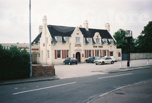
Yew Tree, Yew Tree Lane

Yew Tree, Yew Tree Lane, Northern Moor, Wythenshawe. (c) Gene Hunt at flickr.

The penultimate of Wythenshawe's original interwar estate pubs (others bring the Benchill, Sharston, Royal Thorn, Royal Oak and the Peel Hall) the Yew Tree was a local of mine for a short while, and despite a dodgy reputation, was an OK boozer for a game of darts or an al-fresco pint.  No real ale though and often no punters either, so it was no surprise to see terminal closure a couple of years ago, after many failed attempts to make a go of it.  Local rumours were of flats or a hotel, but Raoshi at the New Yew Tree opened in early 2013 as a bring-your-own Lebanese/Greek restaurant.  I'm unsure whether the depressed and depressing Northern Moor district of Wythenshawe can support this as a going concern, but the couple of online reviews to date are very positive.

Yew Tree, Yew Tree Lane, Northern Moor, Wythenshawe. (c) Gene Hunt at flickr.

Going back to happier times, Alan Winfield visited the Yew Tree, with its Yewtopia club next door, in 1994 when it was a Wilsons house and they offered Wilsons bitter and mild.  Further back and we see the Yew Tree in 1973, these three photos from 1959, and as far back as 1937 when it can't have been open long.  Northern Moor is an under-pubbed area as it is, especially the northern part along Sale Road (I'm sure the area around the Yew Tree used to be known as Kenworthy but can't see it on any maps), with the Gardeners and The Park in the estate and Northenden further afield being the only options now.

Raoshi, Yew Tree Lane. (c) ilovemanchester.

Saturday, 1 June 2013

Travellers Rest, Beech Road

Travellers Rest, Beech Road, Chorlton-cum-Hardy. (c) Chorlton History [1].

This former beerhouse still stands today, next door to the recently rejuvenated Beech Inn on the trendy Beech Road in Chorlton.  The Travellers Rest opened in 1832 and was run by the Nixon family from the 1840s to the 1880s.  It was a tiny boozer, just 11 ft wide and 6 ft long and apparently the front of Franny and Filer jewellers, which is housed in the former beerhouse, is a similar size today.  Whilst there are a numerous drinking establishments on along Beech Road today, the Travellers Rest would have been the only one for a time in the 1800s [1,2].  There is more to be found about the Travellers Rest in Andrew Simpson's new book, The Story of Chorlton-cum-Hardy.

Former Travellers Rest, Beech Road. (c) Google 2013. View Larger Map.

Yew Tree, Brunswick Street

Yew Tree, Brunswick Street, Salford. (c) Neil Richardson [1].

This evocative photo of the Adelphi in the 1950s shows the former Yew Tree marked on the corner of Rigby Street and Brunswick Street.  The beerhouse was one of Salford's first, with an 1829 licence predating the Beerhouse Act by a year.  This meant that before 1830, customers weren't allowed inside to buy beer - they were served through the door or window!  By the 1880s the Yew Tree was owned by Wheater & Swales brewery and it soon passed to Boddingtons.  Being so old, the beerhouse was below street level so that customers had to go down three steps to enter, and in 1907 its licence was revoked [1].  Due to redevelopments in the 1950s and '60s, this part of Salford has been drastically changed, and the lost Rigby Street has been replaced by Tysoe Gardens with Brunswick Street, which ran just east of and parallel to St Stephen Street, lost.

1. Salford Pubs Part One: the Old Town, including Chapel Street, Greengate and the Adelphi, Neil Richardson (2003).

Grove Inn, Brewery Street

Grove Inn (centre), Brewery Street, Salford. (c) Neil Richardson [1].

The Grove Inn can be traced back to a shop run by a butcher on the corner of Rosamond Street and Brewery Street, off Peru Street.  The beerhouse opened in 1836 and in the 1860s, the licensee was a Joseph Holt (probably not not the Joseph Holt) before Groves & Whitnall bought the leasehold in 1898.  The beerhouse was in a bad state so the brewery rebuilt the Grove Inn with a parlour to the front, kitchen at the side and a scullary.  It lasted until 1955 when it was pulled down as part of the Trinity clearance scheme [1].  Brewery Street was lost during redevelopments but it ran pretty much where Brotherton Drive is today, from Peru Street to St Stephen Street.

1. Salford Pubs Part One: the Old Town, including Chapel Street, Greengate and the Adelphi, Neil Richardson (2003).

Friday, 31 May 2013

Dog & Partridge, Elton Street

Dog & Partridge, Elton Street, Chorlton-on-Medlock. (c) Bob Potts [1].

The Dog & Partridge was on the corner of Upper Dobson Street and Elton Street, off Upton Street.  This was just south of Stockport Road near Ardwick Green in the northern part of Chorlton-on-Medlock.  The Dog & Partridge is shown above as an Empress Brewery beerhouse, advertising their ales and stout, and it was taken over by Peter Walker & Son before it closed in 1969 [1].

1. The Old Pubs of Hulme and Chorlton-on-Medlock, Bob Potts (1997).

Horse Shoe, Broad Street

Horse Shoe, Broad Street, Salford. (c) Neil Richardson [1].

The Horse Shoe stood on the corner of Tanners Lane (later Church Street and now Pendleton Way) and Broad Street opposite Pendleton Church, and can be traced back to at least 1774.  It had a bowling green and stables and was in fact known as the Horse Shoe and Bowling Green Inn from the 1820s to 1850s.  The Horse Shoe later advertised "Pure home-brewed ales" from the on-site brewery, as well as Bass, Allsopp's, Dublin stout and London porter in cask and bottle [1].

In 1896 Threlfalls Brewery bought the Horse Shoe and built a new three-storey pub, which in 1915 was advertising a billiard's room with two tables and dining room for four-course lunches.  This grand pub was lost in the 1960s when traffic flows became too much and a compulsory purchase order was issued for road widening.  The Horse Shoe actually survived the 1963 CPO after the brewery argued it was doing tremendous trade.  In 1965 it boasted "Salford's Palace of Variety" but it finally closed in 1969 [1].

1. Salford Pubs Part Three: Including Cross Lane, Broad Street, Hanky Park, the Height, Brindleheath, Charlestown and Weaste, Neil Richardson (2003).

Monsall Inn, Monsall Street

Monsall Inn, Monsall Street, Monsall. (c) Bob Potts [1].

The Monsall Inn stood for 95 years at No.22-26 Monsall Street, off Queens Road in Monsall.  Opening in 1868, it was a Wilson's Brewery boozer advertising Wilsons Ales & Stout, until its closure due to a compulsory purchase order in 1963 [1].  Monsall Street still runs through this drastically redeveloped (and rarely named) corner of north-east-central Manchester.

1. The Old Pubs of Rochdale Road and neighbourhood Manchester, Bob Potts (1985).

Tuesday, 28 May 2013

Black Boy, Lower Moss Lane

Black Boy, Lower Moss Lane, Hulme. (c) Neil Richardson [1].

The Black Boy opened at No.77 Lower Moss Lane on the corner of Bedford Street in 1847 [2] and was a freehouse owned by William Kay of the Britannia Brewery of Hulme [1].  The brewery demolished the original beerhouse, rebuilding a grand boozer which they hoped would get a spirits licence, but this never happened although it was granted a wine licence.  When Wilson's of Newton Heath took over the Britannia Brewery in 1903, the Black Boy became a Wilson's house until its eventual demolition in 1963 after a compulsory purchase order to make way for Chorlton Road [2].

Bob Potts' second book contains a full account of the running of the Black Boy by its final landlord, Harry Mann:  'the Blackie' was a well-built pub with central heating and fire places... it had an oak statue of a black boy placed at the front of a gable wall high above the front door... We sold Wilsons bitter, which was comparable in quality to any bitter sold anywhere.  Our weekly barrelage was three barrels of bitter (108 gallons) and four half-barrels of mild (72 gallons)... The Black Boy was a family pub and entire families got together in the singing-room at weekends... The work in the pub is mainly in the cellar and the pleasure of a pub is in meeting and serving customers [1].

Former location of Black Boy, Lower Moss Lane. (c) Google 2013. View Larger Map.

1. The Old Pubs of Hulme Manchester (1) 1770-1930, Bob Potts (1983).
2. The Old Pubs of Hulme & Chorlton-on-Medlock, Bob Potts (1997).

Derby Arms, Oldfield Road

Derby Arms, Oldfield Road, Salford. (c) Neil Richardson [1].

The Derby Arms beerhouse stood on the corner of West Union Street and Oldfield Road, first recorded in 1869 and bought by the nearby brewery, Threllfalls, in 1881.  Pictured above in about 1930, the Derby Arms was a typical three-door corner boozer, advertising Threllfalls Blue Label Ales on its prominent signage until its closure in 1958 [1].  The spot where the old Derby Arms used to stand is just beyond the sign on the left of the shot below - West Union Street is gone but Duncan Street still runs to the east off Oldfield Road.

Former location of Derby Arms, Oldfield Road. (c) Google 2013. View Larger Map.

1. Salford Pubs Part Two: including Islington, Ordsall Lane and Ordsall, Oldfield Road, Regent Road and Broughton, Neil Richardson (2003).

Ivy Bower, Preston Street

Ivy Bower, Preston Street, Hulme. (c) Bob Potts [1].

The Ivy Bower at No.70 Preston Street opened in 1869 as a Cox's Brewery house [2], closing in 1965 under Wilson's Brewery [1].  The Ivy Bower - the origin of its name a mystery - stood on the corner of Denbigh Street and Preston Street just off Upper Moss Lane in Hulme at the bottm of York Street, a location which now corresponds with the absolute centre of Hulme according to Google Maps.

1. The Old Pubs of Hulme Manchester (1) 1770-1930, Bob Potts (1983).
2. The Old Pubs of Hulme & Chorlton-on-Medlock, Bob Potts (1997).

Sunday, 19 May 2013

Great Eastern, Hancock Street

Great Eastern, Hancock Street, Hulme. (c) Bob Potts [1].

Opening in 1862 as a City Brewery house, the Great Eastern stood on the corner of Orvil Street and Hancock Street off Upper Moss Lane in Hulme.  It passed to a number of breweries before closing in 1965 - Lichfield Brewery, Creese & Co. and the ubiquitous Wilsons [1,2].  The location of the Great Eastern at No.7 Hancock Street was approximately where Rolls Royce Crescent runs south of Stretford Road.  Hancock Street was one street up from the still-surviving Bangor Street, which used to run east to meet Upper Moss Lane (the lower part which is now Rolls Royce Crescent).

Former location of Great Eastern, Hancock Street. (c) Google 2013. View Larger Map.

1. The Old Pubs of Hulme & Chorlton-on-Medlock, Bob Potts (1997).
2. The Old Pubs of Hulme Manchester (1) 1770-1930, Bob Potts (1983).

Albion Inn, Pinder Street

Albion Inn, Pinder Street, Hulme. (c) Bob Potts [1]

The Albion Inn was on the corner of Raglan Street and Pinder Street in the south of Hulme.  It is pictured above in 1961 as a Wilsons Brewery house [1] and at No.22 was the third of three beerhouses in a row on this stretch of Pinder Street - the George Inn at No.18, the Moss Side Inn at No.20.  The latter closed in 1906 but the George and Albion lasted until the late 1960s [1].  The Albion Inn was roughly at the bottom end of today's Peregrine Street, around the back of ASDA, in this vastly changed latest incarnation of Hulme.

1. The Old Pubs of Hulme and Chorlton-on-Medlock, Bob Potts (1997).

George & Dragon, Lower Moss Lane

George & Dragon, Lower Moss Lane, Hulme. (c) Manchester Local Image Collection. Click here to view full image.

The George & Dragon opened at No.63 Lower Moss Lane on the corner with Peel Street, just off City Road, in 1841 [1].  It was a closed Groves & Whitnall house when it was captured in a grimy 1959 photo and in a better shot from the same year.  By then the George & Dragon had been shut for two years.  The top end of Lower Moss Lane  still runs today off Chester Road, but the stretch where the George & Dragon once stood has been lost to redevelopment of this St George's area of Hulme.  Ledburn Court flats on Ledburn Close mark the spot of the old George & Dragon.

1. The Old Pubs of Hulme Manchester (1) 1770-1930, Bob Potts (1983).
2. The Old Pubs of Hulme & Chorlton-on-Medlock, Bob Potts (1997).

Saturday, 18 May 2013

Queens Arms, North Kent Street

Queens Arms, North Kent Street, Collyhurst. (c) Bob Potts [1].

North Kent Street used to run off Collyhurst Street, parallel to North Kent Street in Collyhurst, but it was lost to 1960s redevelopments to be replaced by Thornton Street North.  It contained three boozers; the Crown, the Friendship and the Queens Arms, which opened in 1862.  The Queens at No.3 North Kent Street was owned by the Walkers Brewery of Warrington and it was a classic corner pub with three entrances on two streets - probably the vault, parlour and the public bar.  The Queens Arms closed in 1928, a year before its near neighbour, the Crown [1].

1. The Old Pubs of Rochdale Road and neighbourhood Manchester, Bob Potts (1985).

Stag Inn, Oldfield Road

Former Stag Inn, Oldfield Road, Salford. (c) Neil Richardson [1].

The Stag Inn once stood in a row of four houses between Hope Street and Cow Lane on Oldfield Road.  It opened in the 1840s and was a three-roomed boozer with a stabling yard.  Over the years, shops were built over the front gardens of neighbouring houses so that the Stag Inn was set back from the pavement.  By 1899 the owners, Swales Brewery (of Swales' swill notoriety) were given permission to rebuild the Stag into a three-storey house.  Unfortunately, by 1936 the Stag Inn closed; it has been struggling along selling just  two barrels and six dozen bottles a week, its licence was not renewed, and Swales received £2,804 in compensation from magistrates.  By 1948 the building was a dwelling, followed by a doctor's in the '60s and Jean's Cafe in the '70s and '80s [1].  The Stag in was knocked down at some point in the '80s or '90s to make way for some grim office blocks.

Former Stag Inn, Oldfield Road. (c) Google 2013. View Larger Map.

1. Salford Pubs Part Two: Including Islington, Ordsall Lane and Ordsall, Oldfield Road, Regent Road and Broughton (2003).

Wheatsheaf, Regent Road

Wheatsheaf, Regent Road, Salford. (c) Neil Richardson [1].

The Wheatsheaf was a small beerhouse with parlour and kitchen on the corner of West Burton Street and Regent Road, opening at some time point in the 1860s.  Beers on offer in the early days were from the Greatorex Brewery of Moss Side but by the early 1900s Wilsons Brewery owned it.  They expanded the Wheatsheaf by surrendering their licence of the Crown on Ellor Street, and spread into the sweet shop next door [1].  

Wheatsheaf, Regent Road, Salford. (c) Salford Pubs of the 70s at flickr [2].

The Wheatsheaf lasted until 1974 when it closed and was knocked down a few years later [2] for Regent Road widening.  The old location of this old Wilsons house was roughly here on the south side of Regent Road, on this corner of a short stump of road which roughly matches up to the old West Burton Street.

Former location of Wheatsheaf, Regent Road. (c) Google 2013. View Larger Map.

1. Salford Pubs Part Two: including Islington, Ordsall Lane and Ordsall, Oldfield Road, Regent Road and Broughton (2003).

Monday, 6 May 2013

Old House at Home, Pimlot Street

Old House at Home (left), Pimlot Street, Salford. (c) North Manchester CAMRA [1].

The Old House at Home and Red Lion were neighbouring beerhouses on Pimlot Street off Broad Street, Salford.  Both opened in the 1850s, the Old House being listed in 1858 and under Groves & Whitnall ('Red Rose Ales') owned it by the 1890s.  Exactly 100 years ago, the Old House was almost lost when it was considered for closure at the 1913 brewster sessions.  The police claimed it was less busy that neighbouring boozers, but it was still doing over six barrels a week.  It survived though, and lasted until 28th April 1963 - 'Black Sunday' 50 years ago, when so many Hanky Park and old Salford watering holes were forced to close in the clearance schemes [2].  The old spot where the Old House stood was roughly where the Broadwalk PRU school is today.

2. Salford Pubs Part Three: including Cross Lane, Broad Street, Hanky Park, the Height, Brindleheath, Charlestown and Weaste (2003).

Globe, Monsall Street

Globe, Monsall Street, Monsall. (c) Manchester Local Image Collection. Click here to view full image.

The Globe opened on Monsall Street as a beerhouse in 1865 and was taken on by Threlfalls, eventually being granted its full licence in 1962 [1].  Around this time the Globe passed to Whitbread as the smaller brewery was taken over by the national giant, as shown in 1968, 1971, and from its better side also in 1971 (note the Mackeson - a Whitbread brand - truck unloading the traditional wooden beer barrels).  The Globe gets a mention in the London Gazette in 1880 in John Evitt's bankruptcy case.  This chap lived at the Clarence Inn, Slater Street whilst also working here at the Globe and at the Kings Arms, Whitley Street [2].  The Globe only survived until 1975 when it was closed and pulled down for redevelopment of Monsall into the modern day estate [1].

Globe, Monsall Street. (c) London Gazette.

1. The Old Pubs of Rochdale Road and neighbourhood Manchester, Bob Potts (1985).

Our House, Monsall Street

Our House, Monsall Street, Monsall. (c) Bob Potts (1985).

Our House was a Wilsons boozer that opened at No.124 Monsall Street off Queens Road in Monsall.  Opening in 1868, it had its lease terminated in 1964 for reasons unknown [1].  Monsall Street still runs through the small Monsall council estate today with the Queens Hotel estate pub just off it on Sedgeford Road.

1. The Old Pubs of Rochdale Road and neighbourhood, Bob Potts (1985).

Robin Hood, St Simon Street

Former Robin Hood, St Simon Street, Salford. (c) Neil Richardson [1].

Originally the Wellington Inn, this beerhouse probably opened in the 1850s on St Simon Street along the River Irwell near Springfield Lane. It was soon renamed the Robin Hood and it passed to Groves & Whitnall towards the end of the century.  A 1936 attempt to close the Robin Hood, on the grounds of it no longer being needed, was defeated when magistrates agreed with G&W that three barrels a week was good enough trade for a working class pub like this.  Sadly the Robin Hood closed in the early 1960s although the empty boozer and the shop next door remained standing into the 1980s.  

When the River Irwell was re-channeled the former Robin Hood actually swapped sides of the bank.  It was now sat on the Lower Broughton side of the river and this top end of St Simon Street became Sherbourne Street, while the spot where the beerhouse once stood is roughly on the bottom end of Cottenham Lane today.  The factory that still stands on this corner of Cottenham Lane (see inside Private White V.C. here) is just out of shot to the left in the above photo of the old Robin Hood, waiting for demolition in the '80s.

Former location of Robin Hood, Cottenham Lane, Salford. (c) Google 2013. View Larger Map.

1. Salford Pubs Part One: The Old Town, including Chapel Street, Greengate and the Adelphi, Neil Richardson (2003).

Oddfellows Arms, Kemp Street / Prussia Street

Oddfellows Arms, Kemp Street, Ancoats. (c) Neil Richardson [1].

The Oddfellows Arms stood on the corner of Richmond Street and Kemp (formerly Prussia) Street just off Oldham Road, opening as a public house in 1830.  For a while it was known as the Independent Order of Oddfellows (1851) and Deakin's Vaults, named after the family that owned the Manchester Brewery Company in Ardwick who had the Oddfellows.  The boozer passed to Walker & Homfray and then onto Wilsons, and is shown above in the 1950s and in 1962 at the archive.  The Oddfellows lasted until the early 1970s when it was demolished for development of Ancoats and Miles Platting [1].

Location of Oddfellows Arms, Kemp Street, Ancoats. (c) LizzieW at rootschat.

1. The Old Pubs of Ancoats, Neil Richardson (1987).

Friday, 3 May 2013

City View Inn, Dyson Street

City View Inn, Dyson Street, Miles Platting. (c) Bill Phillips at manmates [1].

The City View Inn stood on the corner of Lewis Street and Dyson Street in Miles Platting.  This north-eastern district of inner city Manchester just off Oldham Road was largely razed to the ground and redeveloped into council housing by the ever-wise Manchester City Council in the 1960s and '70s.  This undoubtedly saw off the City View Inn, however, a short stretch of Lewis Street still runs just south of Varley Street.

1. http://homepage.ntlworld.com/alscot1/CityViewInn.htm.

Regent Hotel, Regent Road

Regent Hotel, Regent Road, Salford. (c) Salford Pubs of the 70s at flickr [1].

To "supply the want that existed for hotel accommodation in the locality", the Regent Hotel was opened in 1866 by Thomas Chesters (founder of the brewery) as a three-storey house on the corner of West Craven Street and Regent Road.  Oddly the Regent was intended to be without a vault - essentially residents only - but probably due to the lack of trade, it soon opened a vault and other public rooms.  The Regent Hotel passed to Whitbread and in 1977 it was closed and demolished as part of Ordsall's redevelopment.  A new Regent, an estate-style pub, was opened close by, but this closed in 1990 [2].

Former location of Regent Hotel, Regent Road. (c) Google 2013. View Larger Map.

1. Salford Pubs of the 70s - www.flickr.com/photos/61756486@N05.
2. 2. Salford Pubs Part Two: Including Islington, Ordsall Lane and Ordsall, Oldfield Road, Regent Road and Broughton, Neil Richardson (2003).

Park Hotel, West Park Street

Part Hotel, West Park Street, . (c) Salford Pubs of the 70s at flickr [1]

The Park Hotel was on the corner of Oxford Street and West Park Street, Ordsall, opening in 1875 as a fully-licensed public house and hotel.  Hardy's Crown Brewery owned the Park by the start of the twentieth century, and the pub was closed and demolished in 1972 [1], seemingly without any photographic record.  Oxford Street used to run just east of Phoebe Street and West Park Street was just south of Robert Hall Street, putting the old location of the Park Hotel roughly where Ledbrooke Close is today.