Pubs of Manchester

All pubs within the city centre and beyond.
A history of Manchester's hundreds of lost pubs.

Wednesday 26 February 2014

Tatton Arms / Boat House Inn, Boat Lane

Tatton Arms, Boat Lane, Northenden, 2007. (c) Keith Williamson at geograph under Creative Commons.

The Tatton Arms is a huge old pub on the banks of the River Mersey on Boat Lane at Northenden, but sadly it's been closed since 2007.  It's in a sorry state having been vandalised - possibly by the same rough lot who frequented the pub towards the end - and left to rot by its irresponsible owners.

Tatton Arms, Boat Lane. (c) David Dixon at geograph under Creative Commons.

The Tatton Arms was originally known as the Boat House Inn, as shown in these two photos from 1898.  The boat house that gave the inn its original name still stands today and was last known to be in good repair and in use by a local theatre company.

Boat House Inn, Boat Lane, 1898. (c) Manchester Local Image Collection. Click here to view full image [1].

It is a well-photographed landmark in South Manchester, seen here in 1937, in 1967 from the other side of the River Mersey, and twice in 1971 with that looks like a Wilsons sign.  The Tatton Arms later became a Chef & Brewer house.  From some angles, like looking at the Northenden Wier, the Tatton Arms resembles a remote country pub.

Tatton Arms, Boat Lane. (c) laivakoira blog.

The Tatton Arms gives its name to the footbridge which crosses the River Mersey in front of the old pub, which is still in use today despite the car park to which it leads being fenced off. 

Tatton Arms, Boat Lane. (c) Gerald England at geograph under Creative Commons.

There used to be a rope-pulled ferry across the Mersey here, and then when the bridge was built, it was a toll-bridge with toll-booths at each end [2].

Tatton Arms from Tatton Arms Footbridge. (c) Gerald England at geograph under Creative Commons.

The Tatton Arms faces an uncertain future, and with an apparent lack of protected status, will surely face demolition like most of the other giant Wythenshawe pubs have.  You can catch a glimpse of the old Tatton Arms without going to Northenden if you keep an eye out when passing on the M60 (as a passenger of course).

Tatton Arms, Boat Lane, 1930s. (c) With permission from Northenden Old & New [3].

Tuesday 25 February 2014

Old Pump House, Clippers Quay

Old Pump House, Clippers Quay, Salford Quays. From Mark Naylor at vimeo. Full photo (c) by Andy Medina at flickr All Rights Reserved [1].

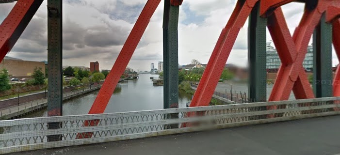
The Old Pump House - no prize for guessing its previous use - was opened at Clippers Quay near the Trafford Road Bridge in June 1992 by Banks's Brewery [2].  It's pictured above in 1993 in glorious detail [1], and Aidan O'Rourke [3] photographed the pub in 1999 looking down from Trafford Road Bridge with the Lowry under construction in the background [4].  

Old Pump House, Clippers Quay. (c) Aidan O'Rourke [3,4].

By mid-2003 the Old Pump House had closed despite being a popular match day venue with United fans.  It was demolished a year later [2] and is now a car park in a much-changed Salford Quays.


Old Pump House, Clippers Quay. (c) adebroom [5].

The Lowry is well-established and the BBC and other media types have moved into Media City.  Sam Platt's pub is still going on the Old Trafford side of the river though only appears to open on match day.

Former location of Old Pump House, Clippers Quay. (c) Google 2014. View Larger Map.

2. Salford Pubs - Part Two: Including Islington, Ordsall Lane and Ordsall, Oldfield Road, Regent Road and Broughton, Neil Richardson (2003).

Red Lion, Pimlot Street

Red Lion, Pimlot Street, Hanky Park, Salford, 1960s. (c) Sue Richardson at North Manchester CAMRA [1].

The Red Lion beerhouse stood next to the Old House at Home in Hanky Park, Salford, opening in the 1850s.  It was on the corner of Raven Street and Pimlot Street and was firstly an Altrincham Brewery house before Chesters Brewery acquired it in the 1890s.  The Red Lion survived police efforts to close it down, who stated that it wasn't need as there were 43 other licensed premises within 300 yards.  However, Chesters argued that they'd renovated it and trade was good, so the Red Lion survived until 1963.  It had been included in the Ellor Street No.3 clearance area and was served a compulsory purchase order in 1959 [2].  The Red Lion stood approximately where the Broadwalk PRU school is today.

Red Lion (right) & Old House at Home (left), Pimlot Street. (c) Sue Richardson at North Manchester CAMRA [1].

2. Salford Pubs Part Three: Including Cross Lane, Broad Street, Hanky Park, the height, Brindleheath, Charlestown and Weaste, Neil Richardson (2003).

Monday 24 February 2014

Chorlton Road Hotel, Chorlton Road

Chorlton Road Hotel, Chorlton Road. Hulme. (c) Bob Potts [1].

The Chorlton Road Hotel was attached to the Chorlton Road Brewery and opened in 1857 at No.69 Chorlton Road in Hulme [2].  The brewery was on the corner of Denton Street and Chorlton Road and was owned by Titus Smalley from the 1860s, them William Dockray who sold most of his pubs to Groves & Whitnall.  It was renamed the Carlton Brewery in the 1890s when Charels Robinson took over and brewing continued at Chorlton Road until 1938.

Chorlton Road Hotel, Chorlton Road. Hulme. (c) Bob Potts [1].

The Chorlton Road Hotel, on the corner of Clayton Street, remained as such until it closed in 1970 having been a Smalley, Dockray and finally Scottish Brewery house [1].  Part of Scottish Breweries, formed by mergers in 1931, was the William Youngers Brewery and the Chorlton Road Hotel is shown here in 1961 undergoing a facelift as a Youngers house.  The location of the brewery and pub was on the corner of what is now Bankwell Street and Chorlton Road.

Former location of Chorlton Road Hotel, Chorlton Road. (c) Google 2014. View Larger Map.

1. The Old Pubs of Hulme & Chorlton-on-Medlock, Bob Potts (1997).
2. The Old Pubs of Hulme Manchester (1) 1770-1930, Bob Potts (1983).

White Lion, Bangor Street

White Lion, Bangor Street, Hulme, 1966. (c) Bob Potts [1].

The White Lion opened on the corner of Mackworth Street and Bangor Street, off Upper Moss Lane, in Hulme in 1855 [2].  It's pictured above in 1966, smashed up and derelict like the streets around it as they waited for the Hulme redevelopments to start.  The White Lion had closed the year before as a Groves & Whitnall house (Red Rose Ales), having previously been owned by William Dockray of the Chorlton Road Brewery, who'd sold his pubs to the larger brewery [1].   The old location of the White Lion is roughly where the corner of Nash Street and Yew Street is in today's vastly changed Hulme.

Former location of White Lion, Yew Street. (c) Google 2014. View Larger Map.

1. The Old Pubs of Hulme & Chorlton-on-Medlock, Bob Potts (1997).
2. The Old Pubs of Hulme Manchester (1) 1770-1930, Bob Potts (1983).

Sunday 23 February 2014

Clarence Inn, Upper Brook Street

 
Clarence, Upper Brook Street, Chorlton-on-Medlock. (c) Manchester Local Image Collection. Click here to view full image [1].

The Clarence Inn was at No.17 Upper Brook Street in Chorlton-on-Medlock.  It was owned by the Peter Walker & Son brewery of Warrington, and closed in 1972.  This archive image from 1970 shows the Clarence Inn in 1970 with the new estates of Chorlton-on-Medlock going up behind it.  It has been dated back to 1864 by the painstakingly comprehensive Pub History website, who also note it was a Tetley's house before it closed [2].  The Clarence straddled Rosamond Place and Caygill Street, both of which have been lost and replaced with Inchley Road and the Jaguar dealership stands on the site of the old Clarence.

Former location of Clarence, Upper Brook Street. (c) Google 2014. View Larger Map.

Corporation Inn, Tipping Street

Corporation Inn, Tipping Street, Ardwick. (c) Manchester Local Image Collection. Click here to view full image [1].

Tipping Street is lost beneath the Mancunian Way and with it, the Corporation Inn.  It was on the corner of the lost New York Street (renamed Hoyle Street) and straddled Egerton Street.  This photo from the 1956 shows a wonderful close-up, with a sign offering Amber ale in bottles.  This from the same year photo shows how the streets around the Corporation were pulled down before the pub was - another case of the pub being spared by thirsty demolition workers?  Doubt it, as four years later it was owned by Groves & Whitnall, as seen in this 1960 shot.  Note the unusual Hoyle Street sign.  

Corporation Inn, Tipping Street. (c) Old Maps [2].

The old location of the Corporation is this corner of Hoyle Street just off the Mancunian Way.  It's not clear when the Corporation Inn was lost but it may have coincided with the building of the inner ring road, the A57(M) in 1963, which swallowed up Tipping Street and would have isolated the pub from the housing north of Ardwick Green.

Former location of Corporation Inn, Hoyle Street. (c) Google 2014. View Larger Map.

Langham, Radnor Street

Langham Hotel, Radnor Street, Hulme, 1936. (c) Bob Potts [1].

The Langham Hotel opened in 1842 [2] on the corner of Bristol Street and Radnor Street in the southern part of Hulme.  It closed in 1965 under a compulsory purchase order  as a J W Lees house and for the last 5 years it was run by George and Flo Pickering.  In 1960 the Langham was rundown but they saw it as a challenge to improve the beerhouse.  Lees' beer was delivered weekly - one and a half barrels of bitter, 18 gallons of Guinness, a hogshead of best mild, 18 gallons of ordinary mild and bottles of Lees Archer stout and Lees Tulip lager.  Inside was installed two ships' lamps and a ship bell used to ring last orders [1].

Flo Pickering gives further insight into the challenges of running a busy beerhouse - up at 7:30am and finishing at 11:30pm with just one afternoon off per week each.  As was the case in all pubs until relatively recently, restricted opening hours in operation, these being 11:30am-3pm and 5:30pm-10:30pm, then 12-2pm and 7pm-10:30pm on Sundays.  These were extended a few years later to 11pm on Fridays and Saturdays.  George Pickering offered a yard of ale (two and a quarter pints), free to anyone who could drink it.  The landlord of the Boston Hotel next door often came in to try it, but the only person to succeed in the Langham was a solider on leave from Germany [1].

Radnor Street used to run approximately where Rawkins Close is in today's Hulme, not far from Old Birley Street and Greenheys Street West.  Most of the old streets are long gone, but a small arms of the old Warwick Street is a reminder of the old Hulme.

1. The Old Pubs of Hulme & Chorlton-on-Medlock, Bob Potts (1997).
2. The Old Pubs of Hulme Manchester (1) 1770-1930, Bob Potts (1983).

Golden Eagle, Stretford Road

Golden Eagle, Stretford Road, Hulme. (c) Bob Potts [1].

The Golden Eagle closed in 1976 as a Wilsons house at No.123 Stretford Road [1].  It was in a block of buildings on the south side of Stretford Road between Vine Street and Dunham Street, opening in 1866 [2].  Vine Street used to run south from Leaf Street, which means the old location of the Golden Eagle was here from the still surviving Leaf Street.
1. The Old Pubs of Hulme & Chorlton-on-Medlock, Bob Potts (1997).
2. The Old Pubs of Hulme Manchester (1) 1770-1930, Bob Potts (1983).

Hare & Hounds, Broad Street

Hare & Hounds, Broad Street, Salford. (c) Tony Flynn [1].

The Hare & Hounds can be traced back to 1788 and stood on the north side of Broad Street, just east of Hanksinson Street.  By the 1890s it was, rather unusually for Salford, owned by J. G. Sykes, a Liverpool liquor merchant and he sold it to Higsons Brewery, the famous Liverpudlian brewers [2].  The above photo shows the Hare & Hounds on the left with the shire horses of the Salford Royal Hospital procession [1]. The Hare & Hounds closed in 1959 and licensee, Stanley Ogden, described his pub as having five rooms along Broad Street, with low arched-roof cellars beneath them.  He also described the rear as having a wide entrance and bow windows and reckoned that this was once the front of the pub [2].  The buildings next to the old Hare & Hounds are still there today.

Former location of Hare & Hounds, Broad Street. (c) Google 2014. View Larger Map.

1. Hanky Park, Tony Flynn (1990).
2. Salford Pubs Part Three: Including Cross Lane, Broad Street, Hanky Park, the height, Brindleheath, Charlestown and Weaste, Neil Richardson (2003).

Grey Horse, Hankinson Street

Grey Horse, Hankinson Street, Hanky Park, Salford. (c) Tony Flynn [1].

The Grey Horse Inn was the first beerhouse to open on Hankinson Street in 1830 after the Beerhouse Act was passed.  This was when Hankinson Street only ran off Broad Street as far down as Primrose Hill, and the Grey Horse was at No.6 on the corner of what was later Newton Street.  There was a brewhouse with its six-barrel copper pan, sixty 30- and 18-gallon barrels and Kent and Herefordshire hops up for sale in 1867.  By the time the police decided the Grey Horse was no longer needed in 1910, Walker & Homfray owned the beerhouse and were duly compensated [2].  The house on the right in the above photo is No.6 Hankinson Street which was rebuilt after the beerhouse had closed [1].  The photographer would have been on Broad Street looking down Hankinson; a very different view is had today.

1. Hanky Park, Tony Flynn (1990).
2. Salford Pubs Part Three: Including Cross Lane, Broad Street, Hanky Park, the height, Brindleheath, Charlestown and Weaste, Neil Richardson (2003).

Thursday 20 February 2014

Bridge Inn, City Road

Bridge Inn, City Road, Hulme. (c) Bob Potts [1].

Opening in 1847 at No.324 City Road [1] the Bridge Inn is pictured above in 1902 [1].  It was on the corner of a tiny street, Brook Side, and City Road and backed onto the old St George's Cavalry Barracks, which later became the recreation ground and is now St George's Park.  Groves & Whitnall owned the Bridge Inn when it closed in 1957 [1].  The old Bridge Inn was on the same trajectory as Nancy Street to the north west, so its old location is roughly as shown below on City Road.  This photo from 1958 shows the site of the old Bridge Inn, which hasn't changed much in almost five decades.

 
Former location of Bridge Inn, City Road. (c) Google 2014. View Larger Map.

1. The Old Pubs of Hulme & Chorlton-on-Medlock, Bob Potts (1997).
2. The Old Pubs of Hulme Manchester (1) 1770-1930, Bob Potts (1983).

Clarence Inn, Bedford Street

Clarence Inn, Bedford Street, Hulme. (c) Arthur Brougham with family's permission.

The Clarence Inn opened at No.39 Bedford Street in Hulme in 1863 [1].  It was situated just off York Street on the corner with Hazel Street which ran between Bedford Street and Rutland Street.  Since Hulme was redeveloped in the 1960s, this street layout has been lost.

Clarence Inn, Bedford Street. (c) Bob Potts [2].

Pictured top in 1963 thanks to Arthur Brougham, and above in the 1950s, the Clarence Inn closed in 1963 as a Wilsons house having previously been owned by the Naval Brewery [2].  The former location of the Clarence is now roughly on the corner of Old York Street and Royce Road.

 
Former location of Clarence Inn, Royce Road. (c) Google 2014. View Larger Map.

1. The Old Pubs of Hulme Manchester 1770-1930, Bob Potts (1983).
2. The Old Pubs of Hulme & Chorlton-on-Medlock, Bob Potts (1997).

Sunday 16 February 2014

Joiners Arms, Cedar Street

Joiners Arms, Cedar Street, Hulme. (c) Arthur Brougham with family's permission.

The Joiners Arms stood on the corner of Russell Street and Cedar Street in Hulme, opening in 1868 [1].  It was a Greatorex Brothers house, it passed to the Empress brewery and the Joiners Arms closed in 1967 under the ownership of Daniel Clifton & Co. [2] of the Royal Oak Brewery in Stockport.  Cedar Street was off Lower Moss Lane, parallel with Stretford Road.  That means the spot where the Joiners Arms stood is roughly in the middle of the Shawgreen Close estate, not far from the old Unicorn estate pub.

1. The Old Pubs of Hulme Manchester 1770-1930, Bob Potts (1983).
2. The Old Pubs of Hulme & Chorlton-on-Medlock, Bob Potts (1997).

Thursday 13 February 2014

Sir Charles Napier / Myles's, Lower Moss Lane

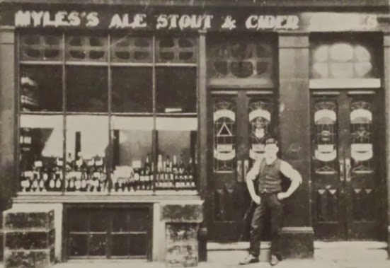
Sir Charles Napier, Lower Moss Lane, Hulme, 1913. (c) Bob Potts [1].

The Sir Charles Napier opened under a unknown name at No.86 Lower Moss Lane, a couple of doors down from City Road, in 1849 [2].  It was named after the Commander of the Baltic Fleet in the Crimean War which ended in 1856, the same year that Samuel Myles took over the beerhouse and renamed it the Sir Charles Napier.  John Myles took over from his father from about 1880 [1], and it was known locally as Myles's, which sold 'Ale Stout & Cider', as the sign above shows in 1913.

The Napier was a rare freehouse and sold beers from Bass, Tetley, Guinness, Allsopp, Jameson and Oakhill breweries.  Beer pumps only being installed in 1920 so before that they were served from the cellar in enamel drugs.  Locals were only allowed to drink in the vault, while friends and associates of Myles were allowed in the back room.  In 1925 the beerhouse was bought by Wilsons and it closed in 1963 as a Tetley's house [1].  The Sir Charles Napier used to stand where City Road and Jackson Crescent meet Chorlton Road.

1. The Old Pubs of Hulme & Chorlton-on-Medlock, Bob Potts (1997).
2. The Old Pubs of Hulme Manchester (1) 1770-1930, Bob Potts (1983).

Monday 10 February 2014

Clayton Arms, Ashton New Road

Clayton Arms, Ashton New Road, Clayton. (c) Manchester Local Image Collection. Click here to view full image [1].

The Clayton Arms was a Wilsons house on the corner of Clayton Lane and Ashton New Road in Clayton, just down the road from the still-serving Holt's house, the Grove.  It's pictured here in 1960 then a decade later, not-much-changed in 1970, and this one from 1964 shows the shops and houses on the other side of Clayton Lane.  After the pub was demolished, probably in the 1970s, a replacement Clayton Arms estate pub was built on nearly North Road, but that has also been lost.  The Clayton Hall tram stop now marks the former location of the old Clayton Arms.

Former location of Clayton Arms, Ashton New Road. (c) Google 2014. View Larger Map.

Palace Hotel, Sidney Street

Palace Hotel, Sidney Street, All Saints, Chorlton-on-Medlock. (c) Manchester Local Image Collection. Click here to view full image [1].

The Palace Hotel was a small hotel was tucked away off Oxford Road on Sidney Street in All Saints.  Pictured above in 1963, it was just three doors down from the electrical shop on the corner of Oxford Road.  These days modern campus-style buildings have replaced much of Oxford Road around the University, with shops at ground floor and student flats above.


Former location of Palace Hotel, Sidney Street (left). (c) Google 2014. View Larger Map.

Sunday 9 February 2014

Nags Head, Wythenshawe Road

Nags Head, Wythenshawe Road, Sale Moor. (c) Trafford Council. Click here to view full image [1].

The Nags Head on the corner of Northenden Road and Wythenshawe Road in Sale Moor was built in the late 18th or early 19th century as a private dwelling.  It became a public house in 1869 and was extended on the Northenden Road side to the right by owners Groves & Whitnall, as shown above in the 1880s.  There were three separate drinking rooms and for a time the kitchen was used as another drinking room [2].  There is another photo at the Trafford Council archives of the Nags Head circa 1900 [2].  

Former Nags Head, Wythenshawe Road. (c) Google 2014. View Larger Map.

Remarkably, part of the old Nags Head appears to be still standing today, having reverted back to use as a private house.  The 19th century extension and the addition down Wythenshawe Road to the left have obviously been removed (the latter to make room for housing), but the central part of the building looks suspiciously like the old Nags Head - even the new windows on the cottage seem to have been faithful reproduction of the pub's.

New Victoria, Kingfisher Close

New Victoria, Kingfisher Close. (c) Mikey at flickr under Creative Commons.

The New Victoria estate pub facing onto the A6 Stockport Road was built in the 1970s to replace the small, original Victoria Inn, seen here in 1969 as a Groves & Whitnalls public house.  Its official address is on Kingfisher Close but the main pub entrance is on the main road.

New Victoria, from Stockport Road, Longsight. (c) Google 2014. View Larger Map.

The New Victoria has recently closed, due to the declining fortunes of owners, Oakwell Brewery.  It did, naturally, offer cask ale in the form of Barnsley Bitter or Oakwell Dark Mild, but its closure now leaves Longsight with just the Gold Cup in this once well-pubbed part of town.


New Victoria, Kingfisher Close. (c) Google 2014. View Larger Map.

Thursday 6 February 2014

Star Inn, Bentinck Street

Star Inn, Bentinck Street, Hulme. (c) Arthur Brougham with family's permission.

The Star Inn opened in 1866 [1] on the corner of Cawdor Street and Bentinck Street, just off Chester Road in the northern-most part of Hulme.  At No.8 Bentinck Street, it was a Scottish Brewers or Mckewan's house, run by a Jockey and Thelma White before it closed in 1974.  It's pictured above amongst the ruins in 1968 on the Cawdor Street side.  When Arthur Brougham took the above photo in 1968 he noticed there was a sign saying 'Pub Still Open'.

Star, Bentinck Street. (c) Alan Winfield with permission.

After the old Star Inn was demolished, a new Star Inn estate-style pub was built on the same spot in in 1975 by Scottish Brewers [2].  This pub is still fondly remembered by older Mancunians but it was demolished after too few years, probably at some point in the 1990s.  Benticnk Street doesn't meet up with Chester Road any more, and the old location of the pubs is hidden from view of the main road.

Former location of the Star Inn, Bentinck Street. (c) Google 2014. View Larger Map.

1. The Old Pubs of Hulme Manchester (1) 1770-1930, Bob Potts (1983).
2. The Old Pubs of Hulme and Chorlton-on-Medlock, Bob Potts (1997).

Wednesday 5 February 2014

Queens Arms (Little Queens), Regent Road

Queens Arms, Regent Road, Salford, 1962. (c) Arthur Brougham with family's permission.

The Queens Arms, or the 'Little Queens', nicknamed to avoid confusion with the other Queens Arms (the Big Queens) on Regent Road, stood next door to the Bridge Hotel.  It can be traced back to 1848 and later that century it belonged to Chesters Brewery.  They acquired two cottages to the rear of the beerhouse with an eye on expansion, but one of them nearly cost the Queens Arms its licence in 1892.  Police mistook its rare telephone line to Manchester as evidence of a betting shop, when in fact it was just the licensee's way of keeping in contact with her businessman husband in town.  

The Queens Arms avoided WWII bombs which fell on Regent Road and Wilburn Street in 1940 (the beerhouse was 5 doors along from Wilburn Street).  Chesters wanted to extend the Queens Arms over the bombed-out shops next door to the Little Queens but the 1962 Regent Road widening scheme prevented this.  Instead, a new Queens Arms was built on the site and the original was demolished.  This estate-style pub changed name to the Sportsmans Tavern in 1985 but closed in 1990 [1].  The Campanile Hotel stands on the location of the old Queens Arms and its replacement estate pub.  The Queens Arms is pictured above here thanks to the late Arthur Brougham.

Former location of Queens Arms, Regent Road. (c) Google 2014. View Larger Map.

1. Salford Pubs Part Two: Including Islington, Ordsall Lane and Ordsall, Oldfield Road, Regent Road and Broughton, Neil Richardson (2003).

21 Piccadilly, Piccadilly

21 Piccadilly, Piccadilly. (c) Gene Hunt at flickr under Creative Commons.

21 Piccadilly (or '21s' as we called it) was an occasional haunt in the 1990s, usually when other venues were full, or turning away groups of worse-for-wear sorts.

21 Piccadilly, Piccadilly. (c) Paul Dean with permission.

Its entrance was just around the corner of Oldham Street next to the Nobel's amusement arcade, and despite going through these doors a few times, I have no recollection of how what lay inside (probably thanks to the Lazy Pig).

21 Piccadilly, Piccadilly. (c) Full image by Ian Pattinson via Skyliner [1]

21 Piccadilly closed a few years ago and Nobel's have recently vacated this site which is to become a Travelodge, Nando's restaurant and Waitrose supermarket [1].

21 Piccadilly, Piccadilly. (c) Paul Dean with permission.

Over the years, 21 Piccadilly has held a rather dodgy reputation, firstly for gang-related trouble in the 1980s and '90s, followed by a low-brow, cheesy standing amongst Manchester's trendier clubs.


21 Piccadilly, Piccadilly. (c) Paul Dean with permission.

That didn't stop the club owners advertising itself as a romantic venue for couples (or singles looking)...

21 Piccadilly, Piccadilly. (c) Paul Dean with permission.

This Manchester Connect Card suggests that the club network offered deals in each others clubs - compliments of the Conservatory.

21 Piccadilly, Piccadilly. (c) Paul Dean with permission.

The building which housed 21 Piccadilly is better known to Mancunians of a certain age as the Woolworth Building, sadly forever remembered for the tragic fire of 1979 which killed 10 people.

Woolworths, Piccadilly, 1979. (c) MEN .

Although a rather unfortunate link to the past, but a memento nonetheless, these sleeves of 21 Piccadilly matches were handed out to revellers in the early 1990s.

21 Piccadilly, Piccadilly. (c) Paul Dean with permission.

Huge thanks to Paul Dean for these mementos of 21 Piccadilly, and many other clubs and bars featured here and yet to come.

21 Piccadilly, Piccadilly. (c) Paul Dean with permission.

1. http://theskyliner.org/post/3940897326/piccadilly-mirror-ball.