Pubs of Manchester

All pubs within the city centre and beyond.
A history of Manchester's hundreds of lost pubs.

Saturday 26 February 2011

Finney's Arms, New Bridge Street

Finney's Arms, New Bridge Street, Salford. (c) Alan Godfrey [1].

Just over the River Irwell into Salford on the corner of New Bridge Street and Greengate stood the Finney's Arms in the mid-1800s [1].  These days, this neglected corner of Salford, just a stones throw from the centre of Manchester, is nothing more than a huge car park.  The 1849 map shows that the pub faced out onto the site of the Market Cross and the site of the Court House - the whole area known as Salford Cross [2].  The  Green Gate fruit & veg market was opposite the Finney's Arms on a triangular plot.  


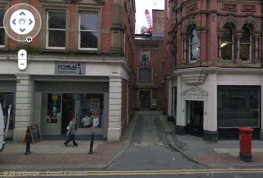
Former location of Finney's Arms, New Bridge Street, Salford. (c) googlemaps.

Finney's Arms was originally the Blue Cap in 1785, but was also known as the Jolly Hatters & Blue Cap, and the Blue Boy.  When Elizabeth Barge took over the Blue Cap in 1825 she renamed it the New Legs of Man (there was a Legs of Man over the road), before the Finney's Arms title was bestowed by Richard Finney in about 1840.  The pub was described as comprising "a bar, bar parlour, club, sitting and tap rooms, all newly painted and papered... arched cellaring and a brewhouse with a 12-barrel copper brewpan [2]."  Holt's Brewery had the pub until its closure in 1915 when the licensing authorities decided that, as it was in an old district where dwellings had been taken down and replaced with factories, that there was "no necessity for the Finney to continue [2]."

1. Manchester Victoria 1849, Alan Godfrey Maps (2009).
2. Salford Pubs - Part One: The Old Town, including Chapel Street, Greengate and the Adelphi, Neil Richardson (2003).

Friday 25 February 2011

Blue Bell, High Street

Former location of Blue Bell, High Street. (c) googlemaps.

The Blue Bell was a large pub on the corner of High Street and Turner Street in the 1800s.  It dwarfed the neighbouring Wheat Sheaf - today's English Lounge (formerly Bensons and Hogshead) - as it used to jut out as a triangular shaped pub rather than the tapered building which now houses the Salimar take away [1]. 

1. Manchester (New Cross) 1849, Alan Godfrey Maps (2009).

Bywater's Hotel, Peter Street

Bywater's Hotel, Peter Street, extract from Manchester As It Is, Benjamin Love [1].

Bywater's Hotel was considered to be one of Manchester principle inns in the 1839, as listed in "Manchester As It Is" [1].  However, by 1849 there was no evidence of it on the Ordnance Survey map [2].

1. Manchester as it is, Benjamin Love (1839).
2. Manchester City Centre (1849), Alan Godfrey Maps (2009).

Spread Eagle, Oldham Road

Former location of Spread Eagle, Oldham Road. (c) googlemaps.

Looking down Oldham Road towards town, on the left, just before Poland Street, is this empty plot on which used to stand the Spread Eagle in the 1800s [1].  The pub was four properties up from Poland Street, but back then a house was one bay wide, so the pub would have been roughly right up against the where the Nicolas and Partners Solicitors office is today.  Down Oldham Street you can see the Victoria Square flats and the Wing Yip Chinese either side.

1. Manchester (New Cross) 1849, Alan Godfrey Maps (2009).

145. City Inn / Mint Hotel, Auburn Street

City Inn hotel, Piccadilly. (c) Pimlico Badger at flickr.

As a post-curry venue this was a dubious one so it came as a surprise that the City Inn served a solitary real beer in the form of a Scottish microbrewery cask ale.  Served a little too cold and in a non-traditional tall pint pot, it was at least preferable to my companions' cocktails and cooking lager.  The City Inn has recently been "refreshed" as the Mint Hotel, so what was the public bar of the City Inn is now the Piccadilly Lounge of the Mint Hotel.  Subdued lighting, trendy but low-key background tunes and a general upmarket feel don't disguise the fact this is still a hotel bar for the transient - business people, weekending couples, tourists.


City Inn hotel lounge, Auburn Street. (c) barblog.co.uk.

The Mint Hotel, facing onto Auburn Street between Aytoun Street and Piccadilly, is part of the Piccadilly Place development, all shiny, and looming over the Station as you reach the top of the Approach.  Only a decade or so ago, the view greeting you outside the station was one of the delightful Piccadilly Indian Restaurant; go back a few more years and the Coach & Horses stood here. This is one part of town which has changed unrecognisably in just a few years - and for the better of course.  Next... sort out the London Road Fire Station.

City Inn Hotel lounge, Auburn Street. (c) Mint Hotel.

Monday 21 February 2011

144. Abode Champagne & Cocktail Bar, Piccadilly


Abode, Piccadilly. (c) awaywithoutthekids.

The public bar of the swanky Abode hotel is a pleasant enough spot for a quiet drink before heading into town for a night out or catching your train home.  Like the equally plush Malmaison and City Inn opposite, this place has brought a touch of class to Piccadilly which contrasts with the Brunswick next door and Waldorf opposite.  The building is a typically grandiose Victorian cotton merchant's warehouse conversion with many original features retained throughout. The main restaurant boasts celebrity chef, Michael Caines, but the order of the day in his "Champagne and Cocktail Bar" is just a few bottled ales for the pub-goer.  We popped in after a few bottles of wine at Cloud 23 so things were getting hazy and I can't recall what the ale of choice was - it was suitably pricey though.  

Abode, Piccadilly. (c) Abode.


Website: www.michaelcaines.com/champagne-bar/manchester.

Friday 18 February 2011

143. Grosvenor Casino, Whitworth Street

Grosvenor Casino, Whitworth Street. (c) Local Data Company.

Normally we exclude private members clubs, however with the new relaxed rules regarding gambling, you can now join on any night and go in for a drink or gamble if that's what takes your fancy.  Therefore it makes it available to anyone and the Grosvenor Casino on Whitworth Street is generally open when everywhere else has closed.

This place is one of the classier casinos available and is in itself a nice place to have a drink, and is pretty much open 24 hours a day if people are in.  There is also an excellent restaurant where you can eat prior to spending a few quid on the tables and machines.  The premises are situated in the former Refuge Assuarance Buildings, one of the most recognisable buildings on the Manchester skyline.  This casino has been here about 25 years now, and clearly its doing something right with other similar places closing in recent times.  No real ale is available as you maybe would expect, but it's worth an occasional trip perhaps just to see how the other half live sometimes.

Thursday 17 February 2011

Whistlers Arms, Back Brewery Street


Former location of Whistlers Arms, Back Brewery Street (Great Ducie Street). (c) googlemaps.

Until 2007 the imposing and world famous Boddingtons Brewery stood here with its Brewery Tap on Great Ducie Street, but now a sorry looking car park is all that this site offers Manchester, the once great ale reduced to a memory.  The Strangeways Brewery was opened in 1788 with the Boddingtons name being adopted when Henry Boddington took full control of the company in 1853.  Around this time, the footprint of the brewery was not as large as in recent times, and between the plant and Great Ducie Street in the mid-1880s was a double row of properties separated by Back Ducie Street and Back Brewery Street.  It was on Back Brewery Street where the Whistlers Arms stood, a little sat back from the road with a rear entrance also on Great Ducie Street [1].  The location of the Whistlers would probably have been where the old Boddies Brewery gatehouse is today, still in use in the car park, just behind the beer casks in the below shot.


Former location of Whistlers Arms (Boddingtons Brewery, Great Ducie Street). (c) deltrems at flickr.

1. Manchester Victoria 1849, Alan Godfrey Maps (2009).

Duke of York, Shudehill

Former location of Duke of York, Shudehill. (c) googlemaps.

Three doors up from the Higher Turk's Head on Shudehill was the Duke of York in the 1800s [1].  These days Mayes Street meets up with Shudehill as seen above, but in the 1880s it stopped just short, ending at the lost North Street which ran behind and parallel to the upper part of Shudehill [1].  The Duke of York stood exactly where the junction and would have faced the Smithfield Markets across the road (rather than the Crowne Plaza today), so, along with the dozen or so other pubs surrounding the markets, would likely have been a traders and hawkers pub.

1. Manchester (New Cross) 1849, Alan Godfrey Maps (2009).

Wednesday 16 February 2011

142. Port Street Beer House, Port Street


Port Street Beer House, Port Street. (c) Tyson's Beer Blog.

When word reached us that a new beerhouse was to open at the other quieter end of the Northern Quarter from the people at Common, it was with a mixture of excitement with some slight disappointment, as this had long been an idea harboured by ourselves.  Indeed we even knew where we would like to have positioned it (a prime spot not far from here!).  Alas our finances were such that this was never likely to be a reality, so we looked forward greatly to seeing the newest addition to the Manchester real ale (beer boffins might say 'craft ale') drinking scene.  And it didn't let us down!

Port Street Beer House itself is situated a couple of doors up from the Crown & Anchor and next door to Cuba Café (the former Stage & Radio Club), and is probably one of those places that you would never know existed unless you walked right past it, were seeking it especially, or have followed the hype about this place since its opening was rumoured back in summer 2010.  Its off-the-beaten-track location indeed adds to the charm, and means people who frequent this place want to be there and haven't just stumbled across it.  Set on two floors with a yard for the smokers or fresh air and sun seekers in the summer, it's very roomy, but still with plenty of seating areas without looking cluttered.  The bar is on one side and is sizeable and more importantly is staffed with knowledgeable folk who know their beer and what a punter is looking for.  Indeed, the chap we were talking to went out of his way to let us have tasters of all the availble brews, to see which we preferred - a nice touch!

Port Street Beer House, Port Street. (c) City Life.

A good selection of beer caters for all palates from the likes of Brew Dog, Dark Star and Prospect.   Everything from light and pale, to the very deepest strongest brews are imaginable in cask, keg and bottled form.  All draught ales we sampled were in tip top form, though the Alpha Dog from the punks of Aberdeen was, quite frankly, a rather dull and savoury affair.  Keg Hardcore IPA was sampled from halves, wisely, as it's a 9.2% hop monster.  Port Street Beer House, being the newest kid on the block so to speak, may take a little while to fully take off, but it was busy enough when we were there on a Saturday evening, and is a fine improvement on some of the other nearby bars.  I can see this one becoming a favourite of ours for years to come like the Castle, and judging by the reaction of Manchester's NQ crowd, so can they.

141. Seven Stars, Printworks

Seven Stars, Printworks, Withy Grove. (c) cask-marque.

Nestled at the back of the Printworks, this Wetherspoons / Lloyds bar would normally be pretty much a no-go area for people like us unless it was particularly early in the day.  Named after the famous 555-year old Seven Stars on Withy Grove that was demolished long before the Arndale Centre rose from the ground, I suspect the drinkers in the original would turn in their grave at the modern day version.  But even so, a beer is a beer, especially an early one, and so at 10:40 am, when already in town and looking for a drink, we give it a whirl.

The premises are large, probably very noisy at night and hard floored for those numerous undoubted spilt drinks, but the beer selection is excellent.  To give Wetherspoons their dues, despite a lot of their pubs being filled with a generally poor level of society, they do keep an excellent selection of beers and rotate regularly. The usual selection of fruit machines and quiz machines can be found, but no pool table and of course no dart board!  We plumped for the Thornbridge Jaipur, a king amongst beers in itself and even better when available at £1.80 a pint, which for a 5.9% brew is fine value indeed.  There were also at least five other real ales on, but time was not on our side, so it was just the one for us this time.  Would we come back?  Possibly for breakfast and an early beer again, but at night time? Highly unlikely I would have thought, we'll leave it to the out-of-town Printworks mob.

Tuesday 15 February 2011

Ranch, Dale Street


The Ranch, Dale Street, 1977. (c) Kevin Cummins / Getty Images [1].

The Ranch on Dale Street is often mentioned as the true home of Manchester punk (Buzzcock Pete Shelley is being carried out of The Ranch in the above snap!) [1].  It was beneath Foo Foo's Palace and was connected to the Foo Foo's by a door behind the bar [2].  As well as playing the staples of Bowie and Roxy Music, The Ranch also was host to bands like Buzzcocks, The Fall and The Distractions.


The Ranch, Dale Street, Distractions flyer, 1977. (c) FranDaman at MDMArchive [1].

Manchester photographer and one-time young punk, Aidan O'Rourke remembers "non-stop cutting edge punk records played at a deafening volume until 2am every night.  The toilets were absolutely disgusting. There were 'punkettes' in their fish net stockings, big hair, heavy make-up a la Siouxsie Sioux and ripped shirts [3]."  Fellow Manc photographer, Kevin Cummins, also took many photos in The Ranch, some of which can be seen here at the Getty Images site [1].

Formerly The Ranch, Dale Street. (c) googlemaps.

1. www.gettyimages.co.uk.
2. www.mdmarchive.co.uk/archive/showartefact.php?vid=240.
3. http://www.aidan.co.uk/forums/archive/index.php?t-328.html.

Monday 14 February 2011

St Mary's Tavern, College Land

Former location of St Mary's Tavern, College Land. (c) googlemaps.

Named after St Mary's Church which stood from 1756 until 1890 (shown here just before it closed), the St Mary's Tavern was on College Land in the mid-1800s [1].  This area is better known today as Parsonage Gardens, or St Mary's Parsonage.

1. Manchester City Centre 1849, Alan Godfrey Maps (2008).

Coach & Horses, Rochdale Road


Coach & Horses, Rochdale Road. (c) googlemaps.

A few yards up Rochdale Road from the Marble Arch and the old Mamas / Victoria Inn is this engineering business on the corner of the main road and Hinton Street.  In the mid-1800s this street was John Street and on this corner stood the Coach & Horses.  Looking back down Rochdale Road to town you can see, from left to right, the flat iron building that faced the Saracen's Head, Mamas / Victoria, and the strange archways that have been retained that sit alongside the fine Marble Arch beer garden.

Rochdale Road. (c) googlemaps.

1. Manchester (New Cross) 1849, Alan Godfrey Maps (2009).

Albert Vaults, Chapel Street

Albert Vaults, Chapel Street, 2008. (c) Andrew Greco.

Albert Vaults has only been closed a few years, one of the many Chapel Street pubs to have been lost to Salford.  The building standing today on Chapel Street, just off New Bailey Street near Salford Central Station, was built in the 1930s, replacing the original which is shown below in the 1890s [1].  In the 1970s the pub was popular with the Irish of Salford and "Saturday night was hoolie night [2]."

Albert Vaults, Chapel Street 1890s. (c) Neil Richardson [1].

The Albert Vaults goes back a long way and was originally known as the Boatswain when it opened in 1872. The old pub had narrow frontage on Chapel Street with a brewery to the rear and was known for a time as the Prince Albert Vaults then the Albert Vaults & Market House.  The Albert Vaults expanded when it spread into the pie shop next door following the building of the railway bridge over Chapel Street in 1893.  Tetley Brewery owned the pub from 1912 and built the new Albert Vaults on the same site, which they eventually sold to Burtonwood in the 1990s when Phoenix Brewery of Heywood also had an outlet [1].


Albert Vaults, Chapel Street, 2008. (c) Matthew Wilkinson at flickr.

Albert Vaults has recently been subject to a strange planning application to turn it into a Brazilian Cultural Centre [3], so looks doomed to never serve as a public house again.  Thankfully the Manchester Photography blog managed to take a few snaps of the pub's interior a couple of years ago [4].  I think I called in here during a Salford pub crawl circa 2004 but don't recall much about it...

Albert Vaults, Chapel Street, 2008. (c) Manchester Photography blog [4].

1. Salford Pubs - Part One: The Old Town, including Chapel Street, Greengate and the Adelphi, Neil Richardson (2003).
2. The Manchester Pub Guide, Manchester & Salford City Centres (1975).

Thursday 10 February 2011

Silver Moon / Patties, Dantzic Place

Dantzic Place and Shudehill tram stop. (c) googlemaps.

The Silver Moon was on Dantzic Place, off Dantzic Street, owned in the 1970s by Terry / Ted Barry then Pete Farrell [1].  Farrell and his wife later renamed the Silver Moon as Patties and changed it into more of a disco [2].  Thanks to 'Tigger' and June at Man Mates for these reminisces.  These days Dantzic Place has been opened up due to the building of Shudehill tram stop, so the Silver Moon / Patties may have been one of the buildings shown.

1. http://manmates.proboards.com.
2. http://manmates.proboards.com.

Normandy, Brazennose Street

Struggling for information on this 1960s club, Normandy on Brazennose Street, other than its listing on the two main Manchester soul club websites, Manchester Soul [1] and Soul Bot [2].  Does anyone remember it?

1. http://manchestersoul.co.uk/msoul/Other_Clubs.html.
2. http://www.soulbot.com/Manchester-Beat-Clubs.htm.

Witch's Broom, Swan Court

The Witch's Broom club was next door to the more famous, and more notorious Liston's Bar on Swan Court, off Market Street [1].  Not sure which side of Liston's, seen here, here and here in 1971, it was on - looks pretty grim either way.

1. http://services.salford.gov.uk.

Piccadilly Pub, Tib Street

Former location of Piccadilly Pub, Tib Street. (c) googlemaps.

Thanks to the memories of those who were around in the rocking '50s and swinging '60s, here's an old one from one of the most knowledgeable gents on there, 'bodzy3'. Opposite the Astoria club on the Piccadilly - Tib Street corner, was the Piccadilly Pub, behind the ground floor windows that are now part of the Debenhams [1].  You can see from this 1959 photo at the Manchester Archive flickr site that little has changed on this lower west side of Tib Street.

1. http://manmates.proboards.com.

Golden Gate, Oxford Road Station Approach

Oxford Road Station Approach. (c) googlemaps.

Not sure exactly where the Golden Gate was on Oxford Road Station Approach, but the place has been mentioned by a few people now.  'Edtheball' at the Manchester Forum remembers the Golden Gate as a "class 'A' gaffe.  My old man - a Daily Express man - knew all the dodgy clubs, and he said that this one was haunted by an assortment of 'hooks, crooks and comic singers'. And after going in a few times - God, we must have been desperate - I knew what he meant [1]."

1. www.manchester-forum.co.uk.

Tuesday 8 February 2011

Zar Bar / Arch Bar / Red Admiral, Hulme Walk


Red Admiral, Hulme Walk, Hulme. (c) Mick Pye.

The Red Admiral was built at the meeting of Stretford Road and Cavendish Street in 1973 [1] to serve the population of the first regenerated Hulme, and was a typical estate pub with open spaces and just two separate rooms.  It was a Robinsons pub serving cask bitter through gas pumps, plus keg Cock Robin and Einhorn lager [2], pictured by Alan Winfield at Pubs Galore.

Zar Bar, Hulme Walk, Hulme, 2008. (c) Manchester Music District Archive.

During further attempts at regeneration in Hulme following the demolition of many of the infamous flats in the area, the pub was substantially renovated and renamed Arch Bar then Zar Bar, but a gang-related shooting in 2007 led to its closure and eventual demolition in summer 2010.

1. The Old Pubs of Hulme & Chorlton-on-Medlock, Bob Potts (1997).
2. The Manchester Pub Guide, Manchester & Salford City Centres (1975).

Tramps, Cross Street

This Tramps was a forerunner to the Tramps on Princess Street, and while a club at night it opened as a vast pub during the day.  The 1975 Pub Guide describes it as possibly Manchester's largest "pub" with five rooms and a separate "Pub Bar" flogging indifferent Tetley bitter, Double Diamond, Skol and Guinness completing the unappetising line-up of beers.  Apparently the Pub Bar was favoured by managers and directors while their younger underlings stayed in the other rooms at dinnertimes [1].  Tramps, at 15 Cross Street, also knocked out good salad and sandwiches, unlike the business that occupies this location today.

Subway, formerly Tramps, Cross Street. (c) googlemaps.

1. The Manchester Pub Guide, Manchester & Salford City Centres (1975).

Monday 7 February 2011

Dock & Pulpit / Borough, Bank Place

Dock & Pulpit, Bank Place, Salford. (c) novaloca.com.

Today's apparent non-story about the Mark Addy being knocked down by Salford Council due to their blanket compulsory purchase order of property in the area brought up this forgotten pub, hidden away off Chapel Street on Bank Place.  The Dock & Pulpit, formerly The Borough, has only been closed since the late 1990s, and is meant to be being either converted into two apartments, demolished and new flats being built in its place, or even converted into offices or a bar/restaurant [1].  Since the above photo was taken the Dock & Pulpit has deteriorated in appearance and remains empty.

Dock & Pulpit, Bank Place, Salford. (c) Eddie_Manchester at flickr.

The Borough Arms beerhouse opened behind St Philip's Church and next to the County Court in about 1860, kept by John Norbury who also gained a billiard licence in 1863.  In 1890 the Altrincham Brewery Company.  sold the pub to Chesters Brewery before it went to Whitbread then Burtonwood Brewery in 1977.


Borough Arms, Bank Place, 1990. (c) deltrems at flickr.

In the 1975 guide the Borough is described as a quiet (empty), two room pub with good cask Trophy [2]. The Borough's last owners were Jo and Andy Davies, before it reopened as the Dock & Pulpit in 1994 for a final handful of years, named after the grand building in Encombe Place which it abuts [3].

Salford County Court, Encombe Place. (c) globrix.com.

1. www.novaloca.com.
2. The Manchester pub Guide, Manchester & Salford City Centres (1975).
3. Salford Pubs - Part One: The Old Town, including Chapel Street, Greengate and the Adelphi, Neil Richardson (2003).

Sunday 6 February 2011

Mosley Arms, New Shambles

Mosley Arms, New Shambles. (c) Alan Godfrey Maps [1].

The Mosley Arms stood on New Shambles, now the lower part of Southgate.  In the mid 1880s this area was home to Deansgate Shambles, a large undercover market area complete with the fruit & veg Deansgate Arcade Market.  Just off Lower King Street (now King Street West), the Mosley Arms was one door down New Shambles, opposite the market's Weights and Measures Office, which stood where San Carlo (Maxwells) is today [1].

Former location of Mosley Arms, New Shambles (Southgate). (c) googlemaps.

1. Manchester City Centre 1849, Alan Godfrey Maps (2008).

Barons Bier Keller, Oxford Street

Possible former location of Barons Bier Keller, Oxford Street. (c) googlemaps.

As the name suggests this was an attempt at a German theme bar, similar to the Bier Keller on Piccadilly and the old Beer Kellar on Wood Street.  The lads from the 1975 Manchester Pub Guide gave it a scathing review - in German obviously - bemoaning the high prices, cheap decor (with no German influence), crap beer (Youngers Scotch, Tartan, Double Diamond) and mainly teenage clientèle [1].  It was on the left side of Oxford Street, possibly in the block shown, but exact location is unknown.

1. The Manchester Pub Guide, Manchester & Salford City Centres (1975).

Olivers Pub Bar, Oxford Street

Apparently this place was formerly part of Fagins (Rafters) night club.  Olivers Pub Bar was open during the day and was a large drinking den with Youngers Scotch bitter, keg Tartan, a "quiet oasis..." and an additional saloon-style bar offering drinkers "compartments with a privacy rarely found in pubs today" [1].  Rafters was thriving throughout the the '70s so it sounds like this place was entirely separate from the club.

1. The Manchester Pub Guide, Manchester & Salford City Centres (1975).

Thursday 3 February 2011

North Westward Ho!, Pomona Dock


North Westward Ho!, Pomona Docks. (c) Chris Bluer / Jud Evans [1].

South of Manchester city centre lies Pomona Dock, seen here in 1925, a reminder of the once thriving Port of Manchester at the end of the Manchester Ship Canal.  While the main docks have been regenerated into Salford Quays, with the BBC moving significant parts of their programming to the site, the smaller Pomona Dock further up the canal towards town remains largely derelict due to ground pollution.  

Pomona Docks. (c) oceangateway.com.

In the 1970s, Pomona Docks was home to one of Manchester's strangest public houses, the North Westward Ho! pubship.  The North Westward Ho ship (b.1938) was bought by Jud Evans in 1972, and after permission was granted for a spot and for an alcohol licence from the Manchester Ship Canal Company and the Licensing Magistrates, the ship was sailed up from Cornwall, down the Ship Canal and birthed at Pomona.  

North Westward Ho, Pomona Docks. (c) Chris Bluer / Jud Evans [1].

A 12-month refit saw her kitted out as the North Westward Ho!, a plush bar and restaurant, offering six bars, Bass ale, late licence and disco - though note the strict dress code!  The success of the ship led to a comet jet being purchased from the RAF and parked next dor to act as an overflow venue, complete with dancefloor [2].


North Westward Ho!, Pomona Docks. (c) Chris Bluer / Jud Evans [1].

After a good decade, the North Westward Ho! closed and was eventually broken up in 1996 [3].  A regular at the Westward Ho and local businessman, Chris Bluer, supplied the above images from a 1973 newspaper cutting [1].


North Westward Ho!, Pomona Docks. (c) Chris Bluer / Jud Evans [1].
1. http://evans-experientialism.freewebspace.com/westward_ho_cutting_1973.htm. 
2. http://evans-experientialism.freewebspace.com/westwardho.htm. 
3. http://www.teesships2.freeuk.com/050403westwardho.htm.

Wellington, York Street

Wellington, York Street, 1968. (c) David Pryer with permission.

The Wellington was hidden away off Grosvenor Street on York Street, and was closed in 1963, an old Threfalls house [1].  It's pictured above in 1968 thanks to David Pryner.  However, the Wellington appears to have had a renaissance as it received rave reviews in the 1975 Manchester Pub Guide [2] and was photographed here in 1973 for the archives.

The Wellington is described as a reminder of the Manchester drinking houses of a long-gone age, with nicotine stained rooms and a cramped corner bar.  Locals would moan about "bloody students" and the ale was excellently kept Whitbread, Tetley and "Chesters fighting mild" (the infamous dark mild that resulted in "Chesters cases").  The Wellington even had a football room - football cuttings covered the wall, a bearded George Best was on the ceiling and there was table football.

Sounds like a cracking boozer - shame it was deceased not long after this glowing 1975 review (according to a hand-written note in the Pub Guide) [2].  Today in this area of All Saints, we have The Pub (left) and Sand Bar (far right) and the Wellington stood down York Street on the right, on the site of the new building behind the no entry sign.

Former location of Wellington, York Street. (c) Google 2011. View Larger Map..

1. The Old Pubs of Hulme & Chorlton-on-Medlock, Bob Potts (1997).
2. The Manchester Pub Guide, Manchester & Salford City Centres (1975).

Devines Wine Bar, Princess Street

The only thing known about this place is that it was a "barn-like wine bar" on Princess Street.  In the 1975 Manchester Pub Guide it didn't get much of a write-up.  It was apparently failing to attract attention despite the 43 wines and three champagnes on offer - no beer, see [1].
Could Devines have been O'Shea's... Joshua Brooks... Overdraught/Rendezvouz?...

1. The Manchester Pub Guide, Manchester & Salford City Centres (1975).

Tuesday 1 February 2011

Cheshire Tavern, Bridge Street

Former location of Cheshire Tavern, Bridge Street, 2010. (c) mrrobertwade (wadey) at flickr.

Down a little alleyway off Bridge Street, just a few doors down from Sawyers Arms, is this grand but hidden building.  The sign 'Hollins Chambers 1925' shows it was the old offices of Hollins law firm [1].  Before the chambers were built, the Cheshire Tavern stood here, run by George A. Scudamore in the mid 1800s [2].  


Former location of Cheshire Tavern, Hollins Chambers, Bridge Street, 2010. (c) googlemaps.

The Cheshire Tavern's address was (and the chamber's is, these days) 64a Bridge Street, but the shot below shows a sign for Bradleys Court.  This is one of Manchester's modern-day hidden streets, as it's not on (m)any maps, nor is it visible from the main street. 

Bradleys Court, off Bridge Street. (c) radaris.com.

1. http://www.thelawyer.com/manchester-merger-takes-georgian-hq/78674.article.
2. Manchester City Centre 1849, Alan Godfrey Maps (2008).