Pubs of Manchester

All pubs within the city centre and beyond.
A history of Manchester's hundreds of lost pubs.

Tuesday 29 April 2014

Church Inn, Church Street


Church Inn, Church Street, Eccles, 1987. (c) Alan Winfield with permission.

The Church Inn stood on Church Street in Eccles, first serving in 1826 and for years it was actually listed as the Church Inn & Bowling Green.  A claim to fame for the Church Inn is that John Moores of Littlewoods Pools, and later, Everton FC's board, was born in the pub as his dad was landlord at the turn of the century [1].

Church Inn, Church Street, Eccles. (c) Tony Flynn [1].

Pictured above in 1959, the Church Inn had a fine bowling green (now part of Eccles Rec) and national matches were held here, "Open To All England" with £10 stakes.  In terms of breweries, the Church first belonged to Wagstaffe's Lion Brewery of Hulme, who were then taken over by Walker & Homfrays, who in turn became part of Wilsons in 1949 [1]. 

Church Inn, Church Street. (c) Tony Flynn [1].

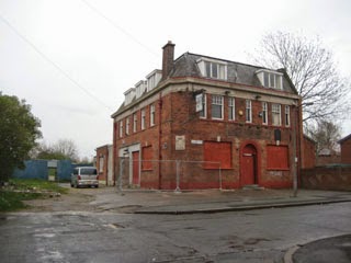
The Church Inn closed at some point in the 2000s and has been demolished, replaced by a car lot.  Having stood at No.215 Church Street, the old Church Inn's location was behind the bus stop facing the still-open Dog & Partridge, as seen in Alan Winfield's 1987 photo of the pub (and his wife), top.

Former location of Church Inn, Church Street. (c) Google 2014. View Larger Map.

1. A History of the Pubs of Eccles, Tony Flynn (1982).

Gas Tavern, Gould Street

Former location of Gas Tavern Gould Street. (c) Google 2014. View Larger Map.

The Gas Tavern stood on Gould Street, spanning Carters Place and Pleasant Place.  This location, even in the mid-1800s, faced the gas works, and today the British Gas Gould Street site is still over the road.  You can see the still-serving and ever-busy Marble Arch (known as the Wellington for most of its life, as on the 1851 map, below) up the road.  The Marble Arch was a popular watering hole for the British Gas staff, along with the sorely-missed Pot of Beer (Harp & Shamrock) and the brilliant Beer House (now the superb Angel).  The Tobacco Factory that sits on the site of the old Gas Tavern have been converted to flats, but the old street layout of Carters Place and Pleasant Place is still present.

Gas Tavern, Gould Street, 1851. (c) Adshead at Digital Archives [1].

1. Adshead's Twenty Four Illustrated Maps of the Township of Manchester divided into Municipal Wards, 1851 at Digital Archives.

Sunday 27 April 2014

Morning Star, Bolton Road

Morning Star, Bolton Road, Pendlebury. (c) Neil Richardson & Roger Hall [1].

The Morning Star opened in 1860 on the corner of George Street and Bolton Road, Pendlebury.  The beerhouse was owned by the Worsley Brewery Company and had only five landlords in its 77 years before it closed in 1937.  There is no evidence for why the Morning Star was closed, and Neil Richardson and Roger Hall [1] speculate that it was simply deemed an unnecessary beerhouse.  There were four others within a stone's throw, including the still-standing but long-closed Station Hotel, named after the old Pendlebury Station.  What is not in doubt was that the 1930s were a tough time for pubs around this part of Salford, with the slump in heavy industry and the start of the slum housing clearance programmes [1].  George Street has been lost but the Morning Star stood midway between Swinton Hall Road and where the railway line passed under Bolton Road.

Former location of Morning Star, Bolton Road. (c) Google 2014. View Larger Map.

1. The Pubs of Swinton & Pendlebury (Including Clifton and Newton), Neil Richardson & Roger Hall (1981).

Saturday 26 April 2014

Old House at Home, Bottomley Side

Old House at Home, Bottomley Side, Blackley, 1995. (c) Alan Winfield with permission.

The Old House at Home was a well-known yet well-hidden pub, tucked away along Bottomley Side in Blackley.  From some angles, such as the one below, it looks like a countryside pub, and indeed it was for many years, after one of the cottages in the row was first licensed to sell beer in about 1861 [1].  


Old House at Home, Bottomley Side, 1961. (c) Roger Hall [1].

Horse races were run in the fields betweent the Old House and Lion Street during Blackley Wakes.  However, from the front in 1958 you can see how it was hemmed in by the industries which came to Crumpsall and Blackley.  Levensteins Works became ICI, and the Wilsons house (from 1937) flourished thanks to thirsty workers adding to local's custom.  


Old House at Home, Bottomley Side. (c) Pugh Auctions.

Quirks of the Old House at Home were that until the 1960s, it was lit by gas and had chemical toilets that were installed before WWII.  Then, in 1978 customers saved the pub from demolition when Wilsons wanted to sell up to ICI [1].  Sadly, the Old House at Home suffered from dwindling custom in recent years and closed in 2011 under long-standing landlord, Hartley Downs, having recently been converted to private housing.


Former Old House at Home, Bottomley Side. (c) Google 2014. View Larger Map. 

1. The Pubs of Blackley, Roger Hall (1980).

Brown Cow, Church Street

Brown Cow, Church Street, Eccles, 1929. (c) Tony Flynn [1].

The Brown Cow was a Walker & Homfrays beerhouse on the corner of Silk Street and Church Street in Eccles, Salford.  Eccles is one of the most heavily-pubbed parts of Greater Manchester but the Brown Cow was demolished in 1930, a year after it closed under landlord, Robert Talbot, who'd run the beerhouse for 40 years.  It can be traced back to at least 1872 and is reported to have attracted the more boisterous elements of Eccles.  In 1888 a local, William Radcliffe from Silk Street, was arrested in the Brown Cow and fought with police, until he was handcuffed and taken to the police station on a milk float [1].


Brown Cow, Church Street, Eccles. (c) Old Maps [2]

These days Silk Street doesn't run all the way up to Church Street, but the former location of the Brown Cow would have been near the Eccles tram stop.  The 1890 1:500 Eccles Town Plan [2] shows the Brown Cow at the top of Silk Street on the old Market Place.  However, it's not named, unlike the still-serving Town Hall Hotel (see map, top left), on account of it being a mere beerhouse rather than public house.

1. A History of the Pubs of Eccles, Tony Flynn (1982).
2. www.old-maps.co.uk/maps.html.

Friday 25 April 2014

Red Lion, Rochdale Road

Red Lion, Rochdale Road, Blackley, 1993. (c) Alan Winfield with permission.

The Red Lion opened in 1858 as a fully-licensed pub on the new Rochdale Road which bypassed Middleton Old Road through Blackley.  Stopford's Brewery took over the Red Lion in the early 1870s, before it passed the Palatine Bottling Company, Walker & Homfray then onto Wilsons Brewery, as pictured below in 1952 and here in 1958.  These two photos from 1968 show the Red Lion and next door, now clearly part of the pub, and not much had changed by 1971 and 1972.

Red Lion, Rochdale Road, 1952. (c) Roger Hall [1].

In the 1980s the Red Lion was still described as a 1960s-style pub that had recently undergone modernisation and was particularly popular with younger drinkers [1].  Since closure - I guess in the mid-2000s - the Red Lion has been converted to private dwellings, and it's hard to tell that the buildings were ever a pub at all.


Former Red Lion, Rochdale Road. (c) Google 2014. View Larger Map.
 
1. The Pubs of Blackley, Roger Hall (1980).

Thursday 24 April 2014

Seedley Hotel, Church Street

Seedley Hotel, Church Street, Pendleton, Salford. (c) Neil Richardson, Tony Flynn, Alan Gall [1].

The Seedley Hotel stood on the corner of Ellor Street and Church Street in the old Hanky Park district of Pendleton, Salford.  It was first licensed in 1868 and by the turn of the century was a Boddingtons beerhouse.  The Seedley was nicknamed 'Jimmy Jones's' after the landlord of 47 years who ran it until he was 90 years old.  Inevitably, the Seedley Hotel was included in the Hanky Park slum clearances - inclusion in the Ellor Street No.7 clearance area saw it close in 1967 [2].  The old location of the Seedley Hotel was roughly here along Pendleton Way, a little north of the old Flat Iron / Royal.

1. Salford's Pubs 4, Neil Richardson, Tony Flynn & Alan Gall (1980).
2. Salford Pubs Part Three: Including Cross Lane, Broad Heath, Hanky Park, the Height, Brindleheath, Charlestown & Weaste, Neil Richardson (2003).

Britannia, Rayson Street (Chapel Lane)

Britannia, Rayon Street, Blackley. (c) Roger Hall [1].

Tucked away on Rayson Street (now Chapel Lane) just of Mill Brow and Exchange Street (now Old Market Street), the Britannia beerhouse was a former shop that was converted by Boardman's Brewery of Cheetham Hill in the 1860s.  The Brit had three rooms - unusual for a beerhouse - including a billiards room [1].


Britannia, Rayson Street. (c) Alan Gall [2].

The Britannia passed to Cornbrook Brewery and was a Bass Charrington house, offering both bitter and mild through beer engines, when it closed in 1978.  The Britannia was demolished for the same traffic scheme that saw off the Wilton Arms, one that that never happened [1].  New houses have since been built on the site of the old beerhouse.

Former location of Britannia, Chapel Lane. (c) Google 2014. View Larger Map.

1. The Pubs of Blackley, Roger Hall (1980).
2. Manchester Breweries of time gone by 1, Alan Gall.

Wednesday 23 April 2014

Globe Inn, Corporation Street

Globe Inn, Corporation Street, Adelphi, Salford. (c) Neil Richardson, Tony Flynn, Alan Gall [1].

The Globe Inn stood on the corner of Mount Pleasant Street and Corporation Street, which was off Peru Street in the Adelphi corner of old Salford.  Pictured above is a picnic party outside the beerhouse held in 1937, courtesy of the rare, original 'Salford's Pubs 4' book [1].  The Globe can be traced back to 1851 and Cornbrook Brewery owned the property by the early 1900s, who survived closure attempts by the police and magistrates in 1907 and 1913.  The Globe was enlarged a few years later when the nearby beerhouse, the Ulster Arms, closed, and it lasted until the Trinity No.5 compulsory purchase order saw it off in 1959 [2].  Today, Mayan Close runs along the old route of Corporation Street and the Globe was about one-third the way down from Peru Street opposite this new small park.

Former location of Globe Inn, Corporation Street. (c) Google 2014. View Larger Map.

1. Salford's Pubs 4, Neil Richardson, Tony Flynn, Alan Gall (1980).
2. Salford Pubs Part Two: Including Islington, Ordsall Lane and Ordsall, Oldfield Road, Regent Road and Broughton (2003).

Rock Inn, Tatton Street

Former Rock Inn, Tatton Street, Ordsall, Salford. (c) Neil Richardson, Tony Flynn, Alan Gall [1].

The Rock Inn was at the easterly end of Tatton Street on the corner with Oldfield Road, opening in the 1860s.  By the early 1900s the Watson, Woodhead & Wagstaffe brewers owned the beerhouse and it survived the 1909 and 1910 brewster sessions, despite having rooms that were too small and a convicted gambler landlord that did the "long pull" (served oversized ales).  Although WW&W promised to improve on its four-per-week beer barrelage, the Rock Inn was handed to Walker & Homfray due to brewery financial problems.  Unfortunately the Rock was closed in 1913 and the building was used as dining rooms in the 1930s before being demolished in about 1970 [2].  The "Rock Inn" sign on the side of the building was still visible for the 50-odd years after the beerhouse closed [1].  Today in the redeveloped Ordsall the eastern end of Tatton Street on the corner with Oldfield Road is St Bartholomew's Drive.

Former location of Rock Inn, Tatton Street. (c) Google 2014. View Larger Map.

1. Salford's Pubs 4, Neil Richardson, Tony Flynn, Alan Gall (1980).
2. Salford Pubs Part Two: Including Islington, Ordsall Lane and Ordsall, Oldfield Road, Regent Road and Broughton (2003).

Monday 21 April 2014

Imperial, Delaunays Road


Imperial, Delaunays Road, Crumpsall. (c) Alan Winfield with permission.

The Imperial was a strange-looking, industrial pub on Delaunays Road in Crumpsall, just south of the former Avecia, Zenace and ICI Building [1], now known as Hexagon Tower science and technology site in Blackley.  This 1966 photo shows its previous incarnation, possibly as a club.

Imperial, Delaunays Road, 2005. (c) Aidan O'Rourke [1].

The Imperial was popular enough with workers despite resembling more of a canteen than a pub, and Alan Winfield rates it as one of the worst two pubs in Greater Manchester - he should know having done pretty much every one in the 1990s.

Imperial, Delaunays Road,1999. (c) Aidan O'Rourke [1].

The Imperial was a Lees house with several function rooms, and lasted until the late 2000s before being pulled down to make way for new houses and apartments.

Former location of Imperial, Delaunays Road. (c) Google 2014. View Larger Map.

Halfway House, Middleton Road


Halfway House, Middleton Road, Crumpsall. (c) Alan Winfield with permission.

The Halfway House at No.2 Middleton Road at the junction with Bury Old Road and Leicester Road closed in the late 2000s and is now in use as Azmirana Solicitors office, retaining some of the old pub signage.  The Halfway House has its upper half decked out in mock Tudor, as seen in 1958 and 1971 as a Cornbrook house and 1985 as a Bass house.

Halfway House, Middleton Road. (c) Alexander P Kapp at geograph under Creative Commons.

An original Half Way House stood here, as seen in this 1927 photo taken on Bury Old Road.  Apparently it was at this original Half Way House that notorious burglar and murderer, Charles Peace, was captured [1]. 

Halfway House, Middleton Road. (c) Google 2014. View Larger Map.

New Inn, Rochdale Road

New Inn, Rochdale Road, Harpurhey. (c) Roger Hall [1].

The New Inn used to stand on the corner of Moston Lane and Rochdale Road in Harpurhey.  Shown above in the 1950s it's also seen here as a Chesters house twice in 1958, 1968 and 1971.  The New Inn was just south of the Farm Yard on the other side of the road, opposite the still-serving Top Derby and diagonally opposite the recently lost Golden Tavern.  The Wellington Inn was just a hundred yards or so along Moston Lane.  The New Inn was built in about 1829 and by the 1870s was owned by Chesters Brewery.  It passed to Threlfalls then Whitbread in 1967 but was bricked up and demolished in 1978 [1].

Former location of New Inn, Rochdale Road. (c) Google 2014. View Larger Map.

1. The Pubs of Blackley, Roger Hall (1980).

Gransmoor / CK's, Ashton Old Road


Gransmoor, Ashton Old Road, Openshaw. (c) Alan Winfield with permission.

The Gransmoor was a big Wilsons pub on the corner of Gransmoor Road and Ashton Old Road in Openshaw.  In the early 1990s Alan Winfield remembers a garishly decorated and predictably empty Banks's pub [1].  A subsequent name change to CK's didn't appear to improve the old Gransmoor.

CK's the former Gransmoor, Ashton Old Road. (c) Proprt.

CK's closed in the mid-2000s and the old pub has since been used as a second hand appliances shop, as mentioned on the 'A Brief Encounter' blog.  This also reminisces about the bands that used to play at the Gransmoor in the 1970s [3].

Former Gransmoor / CK's, Ashton Old Road. (c) John Topping at geograph under Creative Commons.

Former Gransmoor / CK's, Ashton Old Road. (c) Google 2014. View Larger Map.

Saturday 19 April 2014

Wilton Arms, Mill Brow

Wilton Arms, Mill Brow, Blackley. (c) Roger Hall [1].

The Wilton Arms opened on Mill Brow in the 1830s after the Beerhouse Act, one of Blackley's first beerhouses.  It was named after the Earl of Wilton who owned land in Blackley village and the smithy who ran the Wilton Arms was a tenant of the Earl.  By the 1870s, Boardman's Brewery of Cheetham Hill owned the beerhouse and they rebuilt it as part of a terrace and it also had a billiards license.  

Wilton Arms, Mill Brow. (c) Roger Hall [1].

Cornbrook Brewery had the Wilton Arms by the start of the new century and it passed to Bass Charrington before demolition in the early 1970s.  The demolition was ordered due to a traffic scheme which never materialised.  The former location of the Wilton Arms is just to the east of the still-standing but closed Millstone (in the distance, below), opposite the looming Hexagon Tower, a science and technology site.

Former location of Wilton Arms, Mill Brow. (c) Google 2014. View Larger Map.

1. The Pubs of Blackley, Roger Hall (1980).

Cheetham Arms, Long Mill Gate

Cheetham Arms, Long Mill Gate, 1851. (c) Adshead at Digital Archives [1].

The Cheetham Arms is a long-lost pub that stood on the corner of what was Munday Street and Long Mill Gate, and which today is Munster Street and the top end of Corporation Street.  

Cheetham Arms, Long Mill Gate, 1891. (c) www.old-maps.co.uk/maps.html [2].

Situated between the still-serving Ducie Arms and the recently lost-to-the-Co-Op Crown & Cushion, the Cheetham Arms is shown above in Adshead's 1851 map [1] and the 1891 Town Plans [2].

Former location of Cheetham Arms, Munster Street/Corporation Street. (c) Google 2014. View Larger Map.

1. Adshead's Twenty Four Illustrated Maps of the Township of Manchester divided into Municipal Wards, 1851 at Digital Archives.

Haxby Hotel, Haxby Road

Former Haxby Hotel, Haxby Road, Gorton. (c) Pugh Auctions.

The Haxby Hotel is seen here in 1965 as a large (5,000 sq foot), imposing Threlfalls house, despite it bring tucked away at No.3 Haxby Road off Levenshulme Road near Ryder Brow Station in Gorton.  The Haxby Hotel closed relatively recently - I'd guess mid-late-2000s - judging from the photo at Closed Pubs.

Location of Haxby Hotel, Haxby Road. (c) Pugh Auctions.

The Haxby Hotel was really off the beaten track, directly off Yeadon Road, with Levenshulme Road to the west and Hemsworth Road to the south.  The old Haxby Hotel was up for auction and has recently been converted into what's now a huge private property. 

Former Haxby Hotel, Haxby Road. (c) Google 2014. View Larger Map.

Wednesday 9 April 2014

Cromwell Inn, Ashton Old Road

Cromwell Inn, Ashton Old Road, Openshaw. (c) Manchester Local Image Collection. Click here to view full image [1].

On the corner of Wright Street and Ashton Old Road, boasting an Oliver Cromwell sign, the Cromwell Inn is shown here in the 1970s.  The Drovers, which still stands today although no longer serving, was across the road and a bit further towards town is the still-serving Queen Anne (ex-Lord Wolsey).

Cromwell Inn, Ashton Old Road. (c) www.old-maps.co.uk/maps.html [2].

The location of the Cromwell Inn can be seen on the 1891 map, between Wright Street and Cromwell Street on the south side of Ashton Old Road.  Today this spot is nothing but a strangely-gated car park.

Former location of Cromwell, Ashton Old Road. (c) Google 2014. View Larger Map.