Pubs of Manchester

All pubs within the city centre and beyond.
A history of Manchester's hundreds of lost pubs.

Saturday, 7 April 2012

Aces, Clowes Street


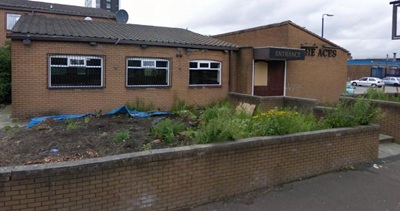
The Aces, Clowes Street, West Gorton. (c) Google 2012. View Larger Map.

The Aces estate pub on Clowes Street in West Gorton is shown in happier times 20 years ago by Alan Winfield when it offered several real ales [1].  Named after the Belle Vue Aces whose old Hyde Road stadium wasn't far from here (their current home at the greyhound stadium is a bit further away), the Aces has been shut for a few years now.
The Aces, Clowes Street, West Gorton. (c) Speedway Plus.

Inside the pub had plenty of speedway memorabilia including photos of Aces legends, Peter Collins, Chris Morton & Co, and apparently race jackets and even a old bike were kept in the pub [2].  Trade from fans drifted away when the Hyde Road stadium was demolished in the late 1980s.

The Aces, Clowes Street, West Gorton. (c) Google 2012. View Larger Map.

1. www.pubsgalore.co.uk/pubs/25693.
2. www.speedwayplus.com/Aces.shtml

Junction, Clowes Street

Former location of the Junction, Clowes Street, West Gorton. (c) Google 2012. View Larger Map.

The Junction used to stand on this corner of Hyde Road and Clowes Street, near to the still-standing, but closed, Dolphin.  The pub is shown at the archives in 1959 as a Chesters pub, in 1971, 1972 and 1972 again as a Whitbread house with the Dolphin in the background along Clowes Street and the West Gorton high-rises.  Alan Winfield snapped the Junction in 1992 when it was back to being a smart-looking Chesters house [1].

1. www.pubsgalore.co.uk/pubs/76480

Dolphin, Clowes Street

Former Dolphin, Clowes Street, West Gorton. (c) Google 2012. View Larger Map.

The Dolphin is shown in 1964 on the corner of Denehurst Street and Clowes Street as a Burton house, and was photographed in 1992 by Alan Winfield when it was owned by Whitbread [1].  After it closed, the Dolphin had a spell as an Indian restaurant, "Timers", but is boarded up these days.  Off Hyde Road, Clowes Street, the birthplace of Manchester City Football Club at St Marks Church, hosts many closed and lost pubs; the Dolphin wasn't even the first one along the street (that was the long-lost Junction).

Former Dolphin, Clowes Street, West Gorton. (c) Google 2012. View Larger Map.

1. www.pubsgalore.co.uk/pubs/76485.

Wednesday, 4 April 2012

Grove, Eccles New Road


Grove, Eccles New Road, Salford, 1950s. (c) Neil Richardson [1].

The Grove was at the other end of the terrace to the huge Ship Hotel at the bottom of Cross Lane and Eccles New Road, and even closer to the Obsorne on the other side.  The beerhouse was on the corner of Eccles New Road and Adderley Street, which was previously known as Strasbourg Street and Prospect Place, opening in 1857 and by the end of the century was owned by Stopford's Brewery of West Gorton.  The Grove passed to Walkers & Homfray, who had their brewery down the next street (Wilmslow Street, where the Osborne was), so they decided to do a swap with Wilsons; W&H would take the Osborne and Wilsons, the Grove.  Even so, only two years later, the two breweries merged and both pubs ended up as Wilsons houses.  The Grove closed in 1979 and was demolished a year later [1].  This corner of Peel Cross Road which leads to the modern Salford County Court is the old location of the Grove.


Grove, Eccles New Road, Salford, 1974. (c) Salford Pubs of the 70s at flickr [2].

1. Salford Pubs - Part 3: Including Cross Lane, Broad Heath, Hanky Park, the Height, Brindleheath, Charlestown and Weaste, Neil Richardson (2003).
2. www.flickr.com/photos/61756486@N05.

Osborne, Eccles New Road

Osborne, Eccles New Road, Salford, 1975. (c) Salford Pubs of the 70s at flickr [1].

The Osborne opened in the 1860s on the corner of Wilmslow Street and Eccles New Road, not far from the bottom of Cross Lane.  In the 1890s the Osborne was leased by Britannia Brewery of Hulme before Wilsons took the beerhouse in 1904.  Walker's & Homfray got the Osborne back when they swapped it with the Grove so they could have their 'brewery tap' before it passed back to Wilsons just two years later when the two brewers merged.  In 1961 the owners were finally given permission to extend into the neighbouring shop and a new front entrance was formed in the shop door and the Osborne's old corner door was bricked up.  Even though most of the buildings around Eccles New Road and Cross Lane had been pulled down for regeneration by 1980, the Obsorne lasted until 1983 [2] and has now been replaced by the Salvation Army HQ.


Osborne, Eccles New Road, Salford, 1951. (c) Neil Richardson [2].

2. Salford Pubs - Part 3: Including Cross Lane, Broad Heath, Hanky Park, the Height, Brindleheath, Charlestown and Weaste, Neil Richardson (2003).

Monday, 2 April 2012

Balmoral Hotel, Rochdale Road

Balmoral Hotel, Rochdale Road, Collyhurst, 1958. (c) Bob Potts [1].

This fantastic looking flat-iron pub was at the meeting of Rochdale Road (to the left) and Collyhurst Road (right) at the point where Topley Street and Scropton Street still lead off Rochdale Road.  Today Collyhurst Road doesn't go this far due to the small estate here today (with its pub, the Valley).  The Balmoral Hotel was a Cornbrook Brewery house and the sign in 1958 proclaims 'Beer Is Best' - who are we to argue.  Here's a side view of the Balmoral from the archives, also in 1958.

1. The Old Pubs of Rochdale Road and Neighbourhood Manchester, Bob Potts (1985).

King William IV, Rusholme Road

King William IV, Rusholme Road, Chorlton-on-Medlock. (c) Bob Potts [1].

Shown in higher resolution at the archives, the 1959 photo of the King William IV shows a Threlfalls house on the corner of Rusholme Road and an unknown side street, just off Upper Brook Street.  This is the lost Chorlton-on-Medlock Rusholme Road rather than the more famous curry mile.  The pub closed in 1967 as the area was cleared for the new Brunswick estate.  A replacement King William IV was built on the new Justin Close, as seen in 1970, and here are four more from 1972, but it only lasted until 1996.

1. The Old Pubs of Hulme and Chorlton-on-Medlock, Bob Potts (1997).

Lincoln's Inn, Preston Street

Lincoln's Inn, Preston Street, Hulme. (c) Bot Potts [1].

Originally named the Lincoln Inn, after Lord Lincoln, rather than Abraham, Lincoln's Inn was on Preston Street in Hulme, which ran between Upper Jackson Street and Upper Moss Lane.  The pub opened in 1867 [1] and closed 102 years later in 1969 having been operated by the Greatorex, Empress and finally Walker & Son breweries [2].  Lincoln's Inn was roughly where the Rolls Crescent Primary School is marked on the map.

1. The Old Pubs of Hulme Manchester 1770-1930, Bob Potts (1983).
2. The Old Pubs of Hulme and Chorlton-on-Medlock, Bob Potts (1997).

Sunday, 1 April 2012

Unicorn / Unicorn & Ship Canal / Union, Union Street


Unicorn, Union Street, Lower Broughton, 1961. (c) Salford Pubs of the 70s at flickr.

The Union beerhouse first opened on Union Street, just off Lower Broughton Road, in around 1855, and when the Unicorn on Chapel Street was pulled down for the building of Blackfriars Road, the licence was transferred.  The Union was enlarged and thus renamed the Unicorn Hotel, and in May 1886, it was advertised as the Unicorn & Ship Canal Hotel.  This was in support of the Manchester Ship Canal shares issue and the pub even displayed models of HMS Victory and HMS Unicorn [2].


Unicorn, Union Street, Lower Broughton, 1920s. (c) Neil Richardson [1].

In 1907 George Sandford advertised that he had taken over the Unicorn after running the Hen & Chickens on Deansgate, and soon after the pub passed to Threlfalls Brewery.  In the 1920s or '30s, Threlfalls rebuilt the Unicorn, from its simple corner boozer style (above) to its grander, cream-clad tiled fronatge (top) which is still seen today, set back off Lower Broughton Road as the Unicorn Nursery.  Before its closure, Whitbread renovated the Unicorn in the early '90s but by 1995 it was closed for good [2].

Unicorn Nursery, the former Unicorn. (c) Google 2012. View Larger Map.

2. Salford Pubs - Part Two: including Islington, Ordsall Lane and Ordsall, Oldfield Road, Regent Road and Broughton, Neil Richardson (2003).

Morning Star, Rolleston Street

Morning Star, Rolleston Street, Miles Platting. (c) Neil Richardson [1].

The Morning Star was a Wilsons house on the corner of Clayton Street and Rolleston Street which today is roughly where Layton Street is marked on Google Maps in the new Miles Platting estate around Bradford Road.  It was nicknamed as Kelly's after Tommy Kelly the landlord and former Barnsley footballer, and lasted until 1959 [1].

1. The Old Pubs of Ancoats, Neil Richardson (1987).

Morning Star / Brown's Bar, Cannel Street

Morning Star, Cannel Street, Ancoats, 1920s. (c) Neil Richardson [1].

On what used to be Canal Street running through Ancoats, the Morning Star on the corner of Bradford Street and Cannel Street closed in 1929 having been one of the first beerhouses in the New Islington district.  When the police objected to its licence in 1906 due to the poor condition of the building, it was known as Brown's Bar (possibly after it's licensee).  The Morning Star was allowed to stay open when Walkers of Warrington refurbished the place and gave up a couple of other beerhouse licences [1].  The former location of the Morning Star is where 'New Islington' street meets Woodward Street.  Of course, the failed Cardroom estate covered this area until quite recently and is not being redeveloped again.

1. The Old Pubs of Ancoats, Neil Richardson (1987).

Bridge, Mill Street

Bridge Hotel, Mill Street, Ancoats, 1912. (c) Neil Richardson [1].

The Bridge Inn opened on the corner of Beswick Street and Mill Street in 1823 and closed as a Wilsons house a couple of years after its neighbour, the Blue Bell, in 1961 [1].  The Bridge Hotel is shown a century ago as a fine-looking Walkers establishment, complete with a well-presented landlord in the doorway, and equally smart Ancoats locals passing by.  Note the advertisement for lager on the roof... 

1. The Old Pubs of Ancoats, Neil Richardson (1987).

Wednesday, 28 March 2012

Old Admiral, Upper Duke Street

Old Admiral, Upper Duke Street, Hulme. (c) Bob Potts [1].

The Old Admiral was a Walkers of Warrington house that stood on Upper Duke Street, off Stretford Road in Hulme.  It had opened in 1869 [1] and closed in 1932 [2].  Upper Duke Street was the next street west of Upper Medlock Street, which still runs through Hulme today, and has been lost beneath the A5103 Princess Road.

1. The Old Pubs of Hulme Manchester (1) 1770-1930, Bob Potts (1983).
2. The Old Pubs of Hulme & Chorlton-on-Medlock, Bob Potts (1997).

Blue Bell, Mill Street

Blue Bell, Mill Street, Ancoats, 1950s. (c) Neil Richardson [1].

The Blue Bell stood on the corner of Carruthers Street and Mill Street and was a Wilsons house when it closed in 1959 [1].  These days a row of council houses ends at this spot at the corner of Carruthers Street and Old Mill Street.  When it opened in 1823 it as the Masonic Inn on Hallsworth Street as Mill Street was once known.  Six years later it was the Blue Bell and had a seven-barrel brewery a decade later [1].

1. The Old Pubs of Ancoats, Neil Richardson (1987).

187. Molly House, Richmond Street


Molly House, Richmond Street. (c) Molly House.

A welcome and much-needed addition to the Gay Village, the Molly House is a two floor pub with tea room on the first floor, a bordello (bar) and verandah (outdoor drinking area) on the second.  Whilst not alone with its gay-friendly camp decor, it is the only pub or bar in the area to offer decent cask ale.  Four or five handpumps offer a good selection of mainly local ales in dimpled pint pots.  We opted for a New Zealand-hopped pale ale and it was in good condition and priced reasonably at just under £3.  Details of the latest beers on at the Molly House are found on the beer and ales section of the website.  The Molly House clearly welcomes straight customers as well and we felt more at home in here than most of the pubs in the Village, bar the unisex toilets - call us old-fashioned. 


Molly House, Richmond Street. (c) Molly House.

Website:  www.themollyhouse.com.

Friday, 23 March 2012

Red Cow, Albion Street


Red Cow, Albion Street, Ordsall, Salford. (c) Salford Pubs of the 70s at flickr [1]. 

Salford's last beerhouse closing in August 1980, the Red Cow is shown here on Albion Street from Donkey Bridge, a vast footbridge which once spanned the Windsor Bridge Cattle Station spur all the way to West Hope Street, Ordsall.  The Red Cow was once a simple corner shop on the corner of Harrogate Street and Albion Street but crucially it was owned by Boddington's.  When the  Freemasons Arms on Spaw Street off Chapel Street and New Bailey Street closed, the brewery transferred its licence to their shop and the Red Cow beerhouse was born.


Red Cow, Albion Street, Ordsall. (c) Salford Pubs of the 70s at flickr [1]. 

The origins of the name, the Red Cow, may be revealed in the forthcoming book about Buffalo Bill's visit to Salford in 1888 by Tom Cunningham - more on that when it's published.  In the 1960s and '70s most of Salford and Manchester's remaining beerhouses were granted full licences, but oddly the Red Cow was an exception and continued to only sell beer - maybe just ale and stout... The Red Cow is pictured in 1980 just before it closed with landlady Lillian Wood and her loyal regulars.

Red Cow, Albion Street, 1980. (C) Kevin Cummins.

The Red Cow was demolished quite soon after it was closed and the building of Albion Way saw Albion Street being lost to the redevelopment.  The old Ripley Street maisonettes shown behind the pub have been remodelled into the Trenham Place houses.  The old location of the Red Cow is roughly in the middle of the south-bound lane of Albion Way where it says A5063 on the map.

 
Red Cow, Albion Street. (c) Salford Pubs of the 70s at flickr [1]. 

The Red Cow was immortalised on film when it acted as the backdrop to a row between Ray and a young Deirdre in a 1970s episode of Coronation Street.  These stills from the video show the Red Cow receiving deliveries of beer barrels from a Boddington's van - staged or not, this is fantastic scene courtesy of the Granada archives.


Red Cow, Albion Street. (c) Coronationstreettube [3].


Red Cow, Albion Street. (c) Coronationstreettube [3].

1. www.flickr.com/photos/61756486@N05.
2. Salford Pubs - Part Three: Including Cross Lane, Broad Street, Hanky Park, the Height, Brindleheath, Charlestown and Weaste, Neil Richardson (2003).
3. www.youtube.com/watch?v=Enj7SKLJPvE.

Spread Eagle, Rochdale Road

The Spead Eagle is pictured below with the 1947 Whit Walk parading past the pub on the corner of Limer Street and Rochdale Road in Collyhurst.  The pub is shown at the Archives as a Cornbrook Ales house in 1958 then in 1971 as a Bass Charrington house complete with delivery lorry outside on Limer Street.

 
Spread Eagle, Rochdale Road, Collyhurst, 1947. (c) Bob Potts [1].

The Spread Eagle closed a couple of years later in 1973 due a compulsory purchase order having been licensed since 1828.  The pub had a short period as the Yorkshire House around 1838 and in the 19th century there was a brewhouse attached [1].  Limer Street is long-lost to new developments off the west side of Rochdale Road, but the old street's little community is shown celebrating the Queen's Coronation in 1953 [2].

 
Limer Street, Collyhurst, 1953. (c) Northwards Housing.

1. The Old Pubs of Rochdale Road and Neighbourhood Manchester, Bob Potts (1985).

Thursday, 22 March 2012

Smith's Arms, Sherratt Steet


Smith's Arms, Sherratt Street, Ancoats, 2009. (c) Mace at flickr.

The Smith's Arms is still standing on Sherratt Street (formerly Spittal Street) in old Ancoats, standing as a defiant relic while old industrial buildings are razed, replaced by the occasional new-build.  It was also known as the Blacksmiths Arms and the Hammer in Hand in the 18th century when it was a Taylors Eagle house, then Tetley's [1], and finally a Burtonwood house upon closure at some point in the 1990s [2].

Smith's Arms, Sherratt Street, Ancoats, 2008. (c) Iain Peacock at flickr.

The Hammer, as it was known locally and signed on the pub, is shown here at the archives in the times when it was hemmed in by the factories and dwellings in the birthplace of the Industrial Revolution.  The Smith's Arms dates as far back as 1775 when it was built as a three-storey middle class residence, and industrialisation led to its conversion to a public house in 1827 [1,2].


Smith's Arms, Sherratt Street, Ancoats, 2009. (c) Mace at flickr. 

Much more information can be found in the 2007 Smith's Arms Archaeological Building Survey by Ivan Hradil, Peter Arrowsmith and Michael Nevell at Manchester University, which can be downloaded from this link at HistoryME [2].  It contains many interior photos of the pub which show the inside in good condition, even if it doesn't look very pub-like any more. 

 
Smiths Arms Burtonwood sign. (c) Smith's Arms Archaeological Building Survey [2].

There is an ongoing effort to get the Smith's Arms on the List of Buildings of Special Architectural or Historic Interest by English Heritage - see the link at HistoryME.  Whilst a noble effort, I won't hold out much hope of this being successful, as pubs are simply not held in high regards by the authorities and many historians, despite them playing such a significant role in our social history.

 
Smith's Arms, Sherratt Street, Ancoats, 1986. (c) Neil Richardson [1].

1. The Old Pubs of Ancoats, Neil Richardson (1987).
2. Smith's Arms Archaeological Building Survey, Ivan Hradil, Peter Arrowsmith and Michael Nevell (2007) (link).

Bridge, Strawberry Road


Bridge, Strawberry Road, Salford. (c) Salford Pubs of the 70s at flickr [1].

On the corner of Strawberry Bank and Strawberry Road, just off Broad Street near the closed Woolpack, the Bridge Inn opened in the 1860s and closed in 1996.  The pub was enlarged in the 1870s when it took over the house next door to make a new tap room and living room, before it became a Wilsons house.  The now extinct Newton Heath brewer had the Bridge until 1989 when a pub company took it over for its final 7 years [2].


Bridge, Strawberry Road, Salford. (c) Salford Pubs of the 70s at flickr [1]. 

As shown on Google Maps, today the Bridge is still standing but as a distinctive, whitewashed building which may have had recent use as the clubhouse of a motorcycle group.  There is still a reminder of the Bridge though, as the old sign peeks out from behind the black boards, albeit unintentionally.  In the past, Strawberry Bank used to run under the railway line and meet up with Cheltenham Street, hence 'The Bridge'.

 
Former Bridge, Strawberry Road, Salford. (c) Google 2012. View Larger Map.

2. Salford Pubs - Part Three: Including Cross Lane, Broad Street, Hanky Park, the Height, Brindleheath, Charlestown and Weaste, Neil Richardson (2003).

Sunday, 18 March 2012

Manchester Cavern / Jigsaw / Magic Village, Cromford Court


Manchester Cavern, Cromford Court. (c) Manchester Beat [1].

Described as the city's best psychedelic and rhythm & blues venue, the Magic Village was started by Roger Eagle of Twisted Wheel fame.  It had previously The Cavern and the Jigsaw Club and was situated on Cromford Court which is now lost beneath the Arndale monstrosity.  Pink Floyd played there in '68, so did The Beatles, The Who, Rod Stewart, The Kinks and the Pretty Things when Jagger and Richards joined then on stage [1]. 


Magic Village, Cromford Court. (c) Maggie Backhouse at Manchester Beat [2].

All-nighters were common at the Magic Village, and although unlicensed, I'm sure there was plenty of other means of intoxication available in there.  Manchester's unlicensed clubs and coffee shops (e.g. the Can Can / Red Bed / Kaleidoscope) played an important yet unheralded part in the musical and social fabric of the city in the '50s and '60s, so many will be featured here.

 
Magic Village, Cromford Court. (c) Maggie Backhouse at Manchester Beat [2].

Although Cromford Court was a victim of the bulldozer, as the heart of old Manchester was ripped out for the Arndale Centre, the name lived on in the name of the Cromford Courts flats that were quirkily built on top of the shopping centre.  Many Mancunians were unaware of these council houses in the sky and although they survived the 1996 IRA blast, they were deemed unfit for habitation in about 2002 and the last of the residents moved out.  Read much more at the essential Mancky [3]. 

Nelson Inn, Upper Jackson Street

 
Nelson Inn, Upper Jackson Street, Hulme, 1960s. (c) Bob Potts [1].

This Chesters house opened in 1859 [2] and lasted over a hundred years until it was demolished in 1970 [1] as pat of the Hulme regeneration efforts of the time.  Bizarrely, as the Nelson Inn was being knocked down, the oddball city planners had commissioned a new pub to open next door, the infamous estate pub, the  Sir Henry Royce.  The newly-erected grim Hulme Crescents can be seen behind the old and new pubs on the newly-christened Chichester Road.

 
Nelson Inn, Upper Jackson Street, Hulme, 1970. (c) Jonnyboy Smith at Facebook.

1. The Old Pubs of Hulme & Chorlton-on-Medlock, Bob Potts (1997).
2. The Old Pubs of Hulme Manchester (1) 1770-1930, Bob Potts (1983).

Saturday, 17 March 2012

Bridge & Crescent, Mount Street

 
Bridge & Crescent Inn, Mount Street, Chorlton-on-Medlock. (c) Bob Potts (1997) [1].

Mount Street off Upper Brook Street in the northern part of Chorlton-on-Medlock has been lost to the A57 Mancunian Way and with it went the Bridge & Crescent Inn.  This Wilsons house closed in 1962 as the area was razed for Manchester's inner-ring road 'motorway' [1].  

 
Bridge & Crescent Inn, Mount Street, Chorlton-on-Medlock. (c) John Smith at Facebook.

The Bridge & Crescent was so-named as it sat above the curve of the River Medlock, hence on the bridge.  The Crescent piece is because the part of Mount Street that bent slightly due to the river's curve was known as 'the Crescent', as shown on the 1824 map of Chorlton Row (as this Chorlton was once known).

 
'The Crescent' on Mount Street, Chorlton Row, 1824. (c) Bob Potts (1997) [1].

1. The Old Pubs of Hulme & Chorlton -on-Medlock, Bob Potts (1997).

Hyde Park Corner, Silk Street


Hyde Park Corner, Silk Street, Salford, 1930s. (c) Nil Richardson [1].

The Hyde Park Corner on Silk Street was demolished in the 1990s, but Joseph Holt's soon rebuilt it and reopened their new estate pub in April 1992, which continues today as one of old Salford's few survivors.  The original beerhouse opened in the 1840s and in the 1880s, the Hyde Park Corner Inn was bought by Fulford & Company Brewers of Hulme, then Empress Brewery, who added the cement rendering that lasted until the end.  It passed to Walkers of Warrington and although it survived the St Matthias clearance scheme in 1956, the demolition of the Silk Street flats saw the Hyde Park Corner close as a Tetley's house in the early '80s.


Hyde Park Corner, Silk Street, Salford, 1986. (c) Salford Pubs of the 70s at flickr [2]. 

1. Salford Pubs Part One: The Old Town, including Chapel Street, Greengate and the Adelphi, Neil Richardson (2003).

Friday, 16 March 2012

All Saints Tavern, York Street

 
All Saints Tavern, York Street, Chorlton-on-Medlock. (c) Jonnyboy Smith at Facebook.


The All Saints Tavern was a Cornbrook Ales beerhouse that straddled Berwick Street and Hill Street on York Street, just off Grosvenor Street / Oxford Road.  It lasted until 1971, a few years longer than it's near-neighbours, the Wellington and the Galloway Arms [1].


1. The Old Pubs of Hulme & Chorlton-on-Medlock, Bob Potts (1977).