Pubs of Manchester

All pubs within the city centre and beyond.
A history of Manchester's hundreds of lost pubs.

Friday 30 August 2013

Bricklayers Arms, Ashton New Road

Bricklayers Arms, Ashton New Road, Bradford. (c) Manchester Local Image Collection. Click here to view full image [1].

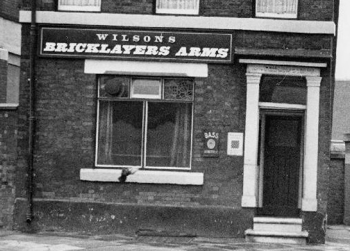
The Bricklayers Arms was a tiny Wilsons beerhouse on Ashton New Road on the Bradford-Clayton border.  This 1960 photo shows the Bricklayers in the shadow of an old bridge which used to pass over to the Clayton Aniline Works.  The chemical works have recently been cleared at great expense and this site is currently being developed by Manchester City into their new training campus.  A works exit was next door to the beerhouse, also seen in 1960, so the little boozer will no doubt have been a popular watering hole with workers.  

These 1964 and 1970 photos show its Wilsons and Bass signs, and even in the late 1970s (possibly '80s), the Bricklayers made it into the second CAMRA Greater Manchester Good Beer Guide [2].  It was included in this rather exclusive list as it offered cask bitter and mild (from electric dispense) unlike many of Manchester's pubs at the time. The old Bricklayers - one of Manchester's last true beerhouses - was lost at some point soon after and its old location was just west of the new-build bank.  Since then the area has been joined by the City of Manchester Stadium, the Velodrome, a huge ASDA and of course the tram.

Former location of Bricklayers Arms, Ashton New Road. (c) Google 2013. View Larger Map.

2. Greater Manchester Good Beer Guide, CAMRA, Ed. Roger Hall (year unknown).

Black Horse Inn, Alport Town

Black Horse Inn, Alport Town. (c) Alan Godfrey Maps [1].

Alport Town was a small, elongated square connecting Deansgate to Watson Street.  The Two Cocks on Deansgate was near the entrance to Alport Town and at the bottom end, on the corner with Watson Street, was the Black Horse Inn, a large public house next door to Alport Lead Mill and backing on to Gratrix's Court, as depicted here at the archives.  Whilst Alport Town is long gone, with the building of the Great Northern Warehouse railway stores, a road of sorts still runs here, in the form of the car park entrance of the Great Northern Warehouse entertainment complex.

Former location of Black Horse Inn, Watson Street. (c) Google 2013. View Larger Map.

1. Manchester (Oxford Street & Gaythorn) 1849, Alan Godfrey Maps (2010).

Phoenix Buffalo Vaults, Fleet Street

Phoenix Buffalo Vaults, Fleet Street. (c) Alan Godfrey Maps [1].

Over three years ago in the Admiral Collingwood entry it was speculated that many pubs and beerhouses must have been lost to the building of Manchester Central Station (GMEX, now Manchester Central again).  This was indeed the case when the station was built between 1875 and 1880.  Along with Great Mount Street, Trumpet Street, Lombard Street, Strand Street and Alport Town (a small square), Fleet Street boasted the Collingwood, King Billy and the wonderfully named Phoenix Buffalo Vaults.  

The Phoenix Buffalo was on the corner of Lower Mosley Street and Fleet Street, next door to the King William IV Inn.  The next nearest pub was then (and still is) the famous old Briton's Protection, and Fleet Street and the Vaults was on the right here, just about where the entrance to the underground car park is today.

Former location of Buffalo Phoenix Vaults, Lower Mosley Street. (c) Google 2013. View Larger Map.

1. Manchester (Oxford Street & Gaythorn) 1849, Alan Godfrey Maps (2010).

Tuesday 27 August 2013

Rocester Arms, Rocester Street

Rocester Arms, Rocester Street, Collyhurst. (c) Bob Potts [1].

The Rocester Arms stood on Rocester Street, a lost street (seemingly named after a Staffordshire village) off Rochdale Road which ran east, just north of Queens Road in Collyhurst.  The Rocester Arms opened as a beerhouse in 1869, passing to the Greatorex Brothers Brewery, the Empress Brewery and Walkers of Warrington, before finally being taken over by Tetley's of Leeds [1].

Former location of Rocester Arms, Rocester Street. (c) Google 2013. View Larger Map.

Under Tetley's the Rocester Arms gained a full spirits licence in 1961 but just three years later, a compulsory purchase order saw the public house demolished [1].  Since 1964, Rocester Street had been lost and recently this site has seen the building of the Manchester Communication Academy ('MCA4U' reads the sign).

Former location of Rocester Street. (c) Google 2013. View Larger Map.

1. The Old Pubs of Rochdale Road and neighbourhood Manchester, Bob Potts (1985).

Oddfellows Arms, Stonehewer Street

Oddfellows Arms, Stonehewer Street, Collyhurst. (c) Bob Potts [1].

The Oddfellows Arms stood on Stonehewer Street in Collyhurst, off Rochdale Road.  This lost street ran just south of Livesey Street which still runs today over to Oldham Road, Miles Platting.  The Oddfellows was a Wilsons house that opened in 1842, lasting until 1964 when it was demolished under a compulsory purchase order [1].  Supposedly this was for regeneration, but fast-forward half a century and only a huge car park is in its place.

Former location of Oddfellows Arms, Stonehewer Street. (c) Google 2013. View Larger Map.

1. The Old Pubs of Rochdale Road and neighbourhood Manchester, Bob Potts (1985).

Monday 26 August 2013

Soap Box / Newton House, Culcheth Lane

Soap Box, Culcheth Lane, Newton Heath. (c) NovaLocal.

The Soap Box on Culcheth Lane in Newton Heath has been closed for a number of years now, deteriorating badly, as seen by comparing these two photos, a couple of years apart.

Soap Box, Culcheth Lane, Newton Heath. (c) RightMove.

Previously called the Newton House as a Marston's pub, the odd three- and two-storey boozer actually has its entrance around the side so from most angles the way in was tough to fathom.

Soap Box, Culcheth Lane, Newton Heath. (c) Google 2013. View Larger Map.

The Soap Box has been up for sale at ever-dwindling pirces (£125,00 above; less than £100k last year).

Soap Box, Culcheth Lane, Newton Heath. (c) RightMove.

Soap Box, Culcheth Lane, Newton Heath. (c) NovaLoca.

Newton House, Culcheth Lane, 1984. (c) D.N. at ManMates Facebook [ ].

Wednesday 21 August 2013

Boatmans Home, Chester Road

Boatmans Home, Chester Road, Knott Mill. (c) Bob Potts [1].

The original Boatmans Home stood at 67 Chester Road on the corner with Great Jackson Street at Knott Mill, opening in 1867 as a Walker & Son's brewery house [1].  It closed exactly 100 years later as an Empress Brewery house [2].  A new Boatman's Home was opened nearby on City Road by brewers Tetley Walker in 1973.  This was yet another example of a grand old pub being replaced by a shabbily-built and short-lived estate pub - of course, the new Boatman's Home has already been pulled down.  Nothing sits on the site of the old Boatmans Home either.

Former location of the Boatmans Home, Chester Road. (c) Google 2013. View Larger Map.

1. The Old Pubs of Hulme Manchester (1) 1770-1930, Bob Potts (1983).
2. The Old Pubs of Hulme & Chorlton-on-Medlock, Bob Potts (1997).

Railway House, Oldfield Road

Railway House, Oldfield Road, Salford. (c) Neil Richardson [1].

This Oldfield Road beerhouse can be traced back to the mid-1800s and it may have first opened as the Lancaster House, as listed in the 1861 census.  It was soon renamed the Railway House, and it stood on the opposite the corner of West Fleet Street to the British Fleet.  In 1886 the Railway House made the news when owners, Stockport's Bell & Company brewery, took the tenant to court after he had left his pub unattended one morning while twenty drinkers were helping themselves to beer!  The beerhouse passed to Walkers Brewery of Warrington by the turn of the century but by 1930 it had closed [1].  The former location of the Railway House was on the south side of Oldfield Road bridge between Liverpool Street and Regent Road.

Former location of Railway House, Oldfield Road. (c) Google 2013. View Larger Map.

1. Salford Pubs Part Two: Including Islington, Ordsall Lane and Ordall, Oldfield Road, Regent Road and Broughton, Neil Richardson (2003).

Sunday 18 August 2013

Imperial Inn, Temperance Street

Imperial Inn (right) and Morland Arms, Temperance Street, Ardwick. (c) Hulme, C.on-M, All Saints, Ardwick FaceBook.

The Imperial Inn stood on Temperance Street in Ardwick; an unlikely name for a street containing a number of lost pubs.  The neighbouring beerhouse opposite the Imperial Inn is the Morland Arms.  Temperance Street still runs from Fairfield Street near Piccadilly Station, along the route of the railway, to Chancellor Lane, Ardwick.

Imperial Inn (right) and Morland Arms, Temperance Street. (c) Hulme, C.on-M, All Saints, Ardwick FaceBook.

The Imperial Inn is shown at the archives in these two photos from 1969 as a Groves & Whitnall house, advertising their Red Rose Ales.  Note the vault and bar parlour etched windows - the vault was the cheap room of pubs and beerhouses, usually wooden or stone floors and only basic seating.  The bar parlour (and the lounge in pubs) would charge a little more for beer, according to the slightly better decor (and supposedly, class of customer).

Former location of Imperial Inn, Temperance Street. (c) Google 2013. View Larger Map.

The Imperial Inn and the Midland Arms used to stand here at the junction of Chapelfield Road, Rachel Street and Temperance Street, just off the Mancunian Way.  This area used to be a mix of residential and factories, but is now semi-derelict with some light industry persisting.

Heaven & Hell, Sackville Street

Heaven & Hell, Sackville Street. (c) Alan Lawson [1].

Heaven & Hell was a 1960s club in an old office building on Sackville Street, with Heaven on the ground floor and Hell in the basement [2].  As with many of the clubs and coffee bars of this period, the club wasn't licensed, but that didn't stop revellers indulging in alternative substances.  Heaven & Hell opened in 1963 and played host to many famous bands of the era - The Hollies, Herman's Hermits - though it was described as a dive of a place.  Downstairs seats were pulled out of buses, punters were often sprawled on the floor, wasted, and it went through a stage of being a hangout of homeless dossers.  The club owner, known as Greek George, stood outside in tears thanking everyone when he was forced to close the club down [2].  The old location of Heaven & Hell is the car park opposite the Thompsons Arms.

Former location of Heaven & Hell, Sackville Street. (c) Google 2013. View Larger Map.

1. It Happened in Manchester: True Story of Manchester's Music 1958-1963, Alan Lawson.

New Inn, Hackle Street

New Inn, Hackle Street, Clayton. (c) D.N. at ManMates Facebook [1].

Pictured here in 1986 thanks to ManMates Facebook [1], the New Inn used to stand on Hackle Street in Clayton.  The Greenall Whitley house appeared to be an estate pub style build with cream tiling making it look a little more presentable.  Hackle Street and some of the surrounding area off North Road has undergone regeneration and today the street is full of new build homes.  The New Inn's old spot was probably on the corner of Canberra Street and Hackle Street.

Former location of New Inn, Hackle Street. (c) Google 2013. View Larger Map.

Friday 16 August 2013

White Horse Inn, Stretford Road

White Horse Inn, Stretford Road, Hulme. (c) Bob Potts [1].

The White Horse Hotel opened at No.245 Stretford Road in 1833 [1], firstly passing to the local Empress Brewery and then to Peter Walker & Son's brewery of Warrington.  The White Horse closed in 1968 [2] as Hulme underwent drastic and disastrous redevelopment, which meant the building of a new, grim estate pub, also the White Horse.

The new White Horse, Stretford Road. (c) dubwise-er at Manchester District Music Archive [3].

Whereas the original White Horse was on the main thoroughfare through Hulme, on the corner of York Street and Stretford Road, its replacement was in the shadow of the hulking Charles Barry, one of the four huge blocks of the infamous Hulme Crescents.  Neither the new White Horse or the Crescents lasted long, being pulled down in the mid-1990s.

The new White Horse, Stretford Road, Hulme. (c) exhulme [4].

1. The Old Pubs of Hulme Manchester (1) 1770-1930, Bob Potts (1983).
2. The Old Pubs of Hulme & Chorlton-on-Medlock, Bob Potts (1997).

Greenheys Hotel, Vine Street

Greenheys Hotel, Vine Street, Hulme. (c) Bob Potts [1].

The Greenheys Hotel on Vine Street in Hulme was a rarity, a Walker Cain's house.  The Liverpool brewer didn't have too many pubs at this end of the East Lancs Road, but the Greenheys Hotel was a fully licensed house opening in 1853 and lasting until 1964.  Vine Street, which used to run south off Stretford Road, and all surrounding streets, houses, pubs and shops were all obliterated from the map during the 1960s and '70s ill-fated regeneration of Hulme.  The site of the old Greenheys Hotel was somewhere near where the Phoenix Way offices are today, just off the Parkway.

1. The Old Pubs of Hulme & Chorlton-on-Medlock, Bob Potts (1997).

Grosvenor Arms / Glue Pot, Eldridge Drive

Grosvenor Arms, Eldridge Drive, Newton Heath. (c) MCRTaxiTours at twitter.

The Grosvenor Arms estate pub is better known to locals as the Glue Pot, and has sadly closed its doors recently, seemingly for the last time.  Tucked away down the residential Eldridge Drive in the Troydale Estate in Newton Heath, the Glue Pot was also nicknamed as the Bottle & Jug back in the day.

Grosvenor, Eldridge Drive. (c) D.N. at ManMates Facebook [1].

The Glue Pot shut in early 2013 and was last seen up for sale for a paltry £70,000 at auction.  This old Lees Brewery house has had something of a dodgy reputation over the years, but even so it was a well-used pub and it's disappointing to see another community boozer bite the dust.  UPDATE: The Glue Pot has reopened as of August 2013.

Grosvenor Arms, Eldridge Drive. (c) Google 2013. View Larger Map.

Thursday 15 August 2013

Joiners Arms, Collyhurst Road

Joiners Arms, Collyhurst Road. Collyhurst. (c) Bob Potts [1].

The Joiners Arms stood at the Queens Road end of Collyhurst Road in Collyhurst, opening in 1869.  It was at No.495 on the corner with Alexandra Street, soon becoming a Wilsons house, as shown above in the 1950s and twice in 1964 at the archives.  The Joiners Arms lasted 95 years, closing under a compulsory purchase order in 1964 [1].  Alexandra Street was lost to the redevelopment of Collyhurst, but it used to run pretty much where Glendower Road runs today.  So the Joiners would have probably stood here on the right (the still serving Valley with its white frontage can be seen in the distance along Glendower Road).

Former location of Joiners Arms, Collyhurst. (c) Google 2013. View Larger Map.

1. The Old Pubs of Rochdale Road and neighbourhood Manchester, Bob Potts (1985).

Bridge Inn, Hendham Vale

Bridge Inn, Hendham Vale, Smedley. (c) Bob Potts [1].

The Bridge Inn, pictured above in the early 1930s, used to stand at No148 Hendham Vale in Smedley, opening in 1848.  Firstly owned by the Bell Brewery of Stockport, it closed as a Walkers of Warrington house in 1933 when its licence was surrendered for the licence of the well-known Princess Hotel, Mauldeth Road, Moss Side.  The Bridge Inn was on the other side of the road to the still standing Smedley Hotel, so it was probably on the left along this stretch of Hendham Vale, where today the road ends and is just a path until it reaches Queens Road.

Former location of Bridge Inn, Hendham Vale. (c) Google 2013. View Larger Map.

1. The Old Pubs of Rochdale Road and neighbourhood Manchester, Bob Potts (1985).

Wednesday 14 August 2013

British Queen, Ellor Street

British Queen, Ellor Street, Hanky Park, Salford. (c) Neil Richardson [1].

The British Queen, on the corner of Bootle Street and Ellor Street in Hanky Park, opened in about 1855 and by 1899 was a Chesters house.  The beerhouse lasted until the 1960 Ellor Street No.4 slum clearance saw it served a compulsory purchase order.  Like the other Ellor Street pubs, the British Queen lasted until 'Black Sunday' (18/4/1963) when it closed straight after the dinnertime session (12-2pm).  The Salford City Reporter: "The pumps were empty and the bottle shelves were bare [1]."  

The fantastic shot above, entitled "Like islands in a sea of rubble", shows the British Queen in April 1963 just before demolition surrounded by rubble (pub demolition theory).  The drastic redevelopment of this part of Pendleton, Salford practically wiped the Hanky Park district off the map.  Churchill Way runs slightly south of where Ellor Street used to run off Cross Lane, so the British Queen would have been roughly where the Kiwi Street high rise flats stand.

Former location of British Queen, Churchill Way. (c) Google 2013. View Larger Map.

1. Salford Pubs Part Three: Including Cross Lane, Broad Street, Hanky Park, the Height, Brindleheath, Charlestown and Weaste, Neil Richardson (2003).

Nelson Inn, Orsdall Lane

Nelson Inn, Ordsall Lane, Ordsall, Salford. (c) Neil Richardson [1].

The Nelson Inn stood on the corner of Ashworth Street and Ordsall Lane, and opened in 1860s to serve the new houses of Ordsall as the southern part of Ordsall was being laid out across the lane.  It belonged to the Neptune Brewery of Oldham Road, Manchester in 1891, when it comprised a bar, parlour, kitchen, scullery and two rooms upstairs.

Empress Brewery of Old Trafford had the Nelson by the early 1900s, and they were selling 14 barrels of beer a week in 1913, so they extended into part of the pawnbrokers next door, resulting in an extra entrance on Ordsall Lane.  Decorated in classic Empress tiling, the Nelson lasted until the 1969 wave of Ordsall regeneration [1].  This wiped Ashworth Street off the map, but it was about 80 yards south of Fairbrother Street, so the Nelson probably stood here:

Former location of Nelson, Ordsall Lane. (c) Google 2013. View Larger Map.

1. Salford Pubs Part Two: Including Islington, Ordsall Lane and Ordsall, Oldfield Road, Regent Road and Broughton, Neil Richardson (2003). 

Clough Tavern, Ordsall Lane

Clough Tavern, Ordsall Lane, Ordsall, Salford. (c) Neil Richardson [1].

The Clough Tavern was the next pub along Ordsall Lane after the Ordsall, on the corner of West Park Street.  Opening in the 1860s in what had previously been part of Ordsall Wood opposite Worrall's dyeworks reservoirs (Worrall Street still runs off Ordsall Lane here), by the start of the next century, Stopford's Brewery owned the beerhouse.

The Clough Tavern had a corner vault with clubroom above, and as it passed to Walker & Homfrays in 1927, the kitchen and vault had been knocked into one.  It passed to the W&H subsidiary, the Palatine Bottling Company, 10 years later before becoming a Wilsons house in the '50s.  The Clough Tavern was closed and pulled down in 1969 [1].

Former location of Clough Arms, Ordsall Lane (right). (c) Google 2013. View Larger Map.

1. Salford Pubs Part Two: Including Islington, Ordsall Lane and Ordsall, Oldfield Road, Regent Road and Broughton, Neil Richardson (2003). 

Tuesday 13 August 2013

Bricklayers Arms, Moston Lane

Bricklayers Arms, , Moston. (c) David Dixon at geograph under Creative Commons

The Bricklayers Arms was an old Wilsons house at 140-142 Moston Lane.  Towards the ends of its life it was a freehouse as shown in these sad photos of a rotting and boarded up old boozer.  This 1972 photo from the archives shows the Bricklayers in better times with its Wilsons signs, vault brickwork and a 1929 construction date.

Bricklayers Arms, Moston Lane. (c) Gene Hunt at flickr under Creative Commons.

The Bricklayers Arms sadly closed in the mid-2000s and was bought by Nadia Homes, who were taken to court and fined £4,000 for allowing the pub to deteriorate and become derelict.  The Doncaster-based developers were warned that further fines would follow if they failed to clean up the site [1].

Former location of Bricklayers Arms, Moston Lane. (c) Google 2013. View Larger Map.

As can be seen on Moston Lane today, and above, the developers did nothing and the Bricklayers was eventually demolished.  This leaves a pub-shaped plot (though the pub can still be seen on the aerial shot, below) at the top of Hillier Street North, along which the closed Moston Hotel still stands today.

Bricklayers Arms, Moston Lane. (c) Google 2013. View Larger Map.

Monday 12 August 2013

Queen's Hotel / Andrew's Arms, Rochdale Road

Queen's Hotel, Rochdale Road, Harpurhey, 1958. (c) Alan Gall [1].

The Queen's Hotel was a large pub on the corner of Glenville Street (formerly Goodier Street) and Rochdale Road (No.787) in Harpurhey.  This clearer copy of the above 1958 photo shows how the Queen's had HARPURHEY stone work on the roof, and this shot from the same year shows the shop on the other corner with a sign for the Cornbrook house, the Lord Lovat, which was just down on Camelia Road.

The pub was fully licensed from 1826 when it was known as the Andrew's Arms; the name change came after the municipal Queen's Park opened nearby in 1846.  Bernard McKenna, co-founder of Harpurhey Brewery, had the Queen's in the 1870s when it was nicknamed McKenna's Vaults.  Walker & Homfray then Wilsons had the Queen's Hotel before it was pulled down under a compulsory purchase order in 1959 [2].

Former location of Queen's Hotel, Rochdale Road, Harpurhey. (c) Google 2013. View Larger Map.

The old location of the Queen's Hotel is roughly where Kesteven Road runs today just off Rochdale Road, just north of the Manchester General Cemetery.  The former Foresters Arms can be seen in the distance on the right.  Although there is no direct access, 50 yards or so back from the main road here is the site of the old Lord Lovat which has been demolished far more recently than the old Queen's.

1. Manchester  Breweries of times gone by, Alan Gall (year unknown).
2. The Old Pubs of Rochdale Road and neighbourhood Manchester, Bob Potts (1985).