Pubs of Manchester

All pubs within the city centre and beyond.
A history of Manchester's hundreds of lost pubs.

Saturday, 7 January 2012

Derby Arms, Derby Street

Derby Arms, Derby Street, Ordsall. (c) John Bulmer at How to be a Retronaut.

Last year we asked you to "name that pub" after John Bulmer featured this evocative photo (and one of the old Broadway) on How to be a Retronaut.  At the time, this one stumped us, but 10 months after the post, Mr Wilson (Paul Wilson, Salford Housing Officer and collator of the superb Salford Pubs of the 70s photos at flickr) cleared it up for us.


Derby Arms, Derby Street, Ordsall. (c) Salford Pubs of the 70s at flickr [2].

The Derby Arms on Derby Street was once surrounded by the terraced houses of Ordsall on the corner of Zebra Street as recently as 1972, as shown above.  In the '70s, most of Ordsall's houses were systematically destroyed in the name of redevelopment - by the mid-'70s you can see the next door properties were gone, as shown below.

Derby Arms, Derby Street, Ordsall. (c) Neil Richardson [3].

By 1977 when John Bulmer took his photo, the only the Derby remained; the last tooth in a rotten mouth.  Despite the common policy of retaining a few old pubs when rebuilding housing estates like this, the Derby Arms was actually pulled down in July 1977, confirming that Bulmer's photos were from early, winter 1977.


Derby Arms, Derby Street, Ordsall. (c) John Bulmer at How to be a Retronaut.

The Derby Arms - known as the 'Little Derby' due to the Derby Hotel a few yards down the street - was first licensed in 1865, being owned by Swales Brewery in the early 20th century.  Licensee Annie Gouldin got into bother in 1914 for selling "Swales swill" at less than the usual minimum price of 2d a pint (many Swales houses  had cards in their windows advertising pints at 1 1/2d) [3].


Derby Arms, Derby Street, Ordsall. (c) John Bulmer at How to be a Retronaut.

In 1971, the Little Derby became a Boddingtons house (you can just make out the small sign above the main door) [3].  I wonder if the smartly-dressed mystery gent walking away from the pub is so pleased as he has a belly full of Boddies?  They were the days when the pale and bitterly hoppy ale truly was the Cream of Manchester.

1. www.howtobearetronaut.com/2010/10/john-bulmers-north.
2. www.flickr.com/photos/61756486@N05.
3. Salford Pubs - Part Two: Including Islington, Ordsall Lane and Ordsall, Oldfield Road, Regent Road and Broughton, Neil Richardson (2003).

Thursday, 5 January 2012

Talbot / Ladybarn, Mauldeth Road

Ladybarn, Mauldeth Road, Ladybarn. (c) Gene Hunt at flickr under Creative Commons.

This grand-looking boozer in Ladybarn was once ran by Frank Swift, the legendary Manchester City goalkeeper who died in the Munich Air Disaster in 1958 along with eight United players, plus 14 others.  In the 1950s when Swift had it before he became a journalist, the pub was known as the Talbot and there are archive photos from 1959 and 1970 as a Threlfalls house, plus one from Alan Winfield in 1993 as a Whitbread pub.


Ladybarn sign, Mauldeth Road. (c) Ladybarn at Facebook.

In recent years the Talbot had a spell as 'Peninsular' which was a student pub with a seaside theme.  Its final hurrah was as The Ladybarn when it reinvented itself as a food-led pub, receiving some favourable reviews as recently as 2006 [1].  However, the pub didn't last long, being knocked down in early 2010, despite appearing still standing on googlemaps on the corner of Ladybarn Lane.  The photo below shows the pub wall before complete demolition with the still open Brewers Arms in the background.

Former location of Talbot / Ladybarn, Mauldeth Road, 2010. (c) Talbot at Facebook.

1. http://menmedia.co.uk/food_and_drink/s/214667_barnstorming_welcome.

Church Inn, Derby Street

Church Inn, Derby Street, Ordsall, 1965. (c) Salford Pubs of the 70s at flickr [1].

Derby Street in Ordsall has been completely lost since the redevelopment of this part of Salford, just south of Regent Road. Whereas in the past, Derby Street used to run just to the west of and parallel to Oldfield Road, today the small estate of St Bartholomew's Drive and Chancel Avenue has replaced the northern part where the Church Inn once stood.  The Church beerhouse stood on the corner of Parsonage Street and can be traced back to 1861 and by the early 1900s was owned by Wilsons Brewery.  In the 1920s they rebuilt the Church Inn and the pub survived until 1974 when it was bulldozed soon after to make way for the new housing estate [2].

Church Inn, Derby Street, Ordsall, 1965. (c) Neil Richardson [2].

1. www.flickr.com/photos/61756486@N05.
2. Salford Pubs - Part Two: Including Islington, Ordsall Lane and Ordsall, Oldfield Road, Regent Road and Broughton, Neil Richardson (2003).

Wednesday, 4 January 2012

Brewers Arms, Rochdale Road

Brewers Arms, Rochdale Road. (c) Bob Potts [1].

The Brewers Arms stood at the bottom of Rochdale Road on the corner of what is now Kenwright Street (then Kenyon Street).  This unheralded street is parallel to the much-better known Angel Street and the fine boozer, the Angel / Beer House / Weavers.  The Brewers Arms was originally licensed as smaller pub one door along Kenyon Street [2], and was run by Christopher Kenyon who also ran St George's Brewery behind the pub.  At some point it was rebuilt as the fine Rochdale Road pub shown above and on the rear of Bob Potts' Pubs of Rochdale Road booklet [1].  Chesters Brewery had the Brewers Arms for a time, as did the Empress Brewery of Old Trafford. The last owners were Walkers of Warrington, before the pub was closed in 1942 on the grounds of non-requirement [1].


Former location of Brewers Arms, Rochdale Road. (c) Google 2011. View Larger Map.

1. The Old Pubs of Rochdale Road and Neighbourhood Manchester, Bob Potts (1985).
2. Manchester (New Cross) 1849, Alan Godfrey Maps (2009).

Druids Arms, Liverpool Street

Druids Arms, Liverpool Street, Salford. (c) Salford Pubs of the 70s at flickr [1].

This unlikely survivor of Salford is a café-sandwich bar today and can be traced back to 1850s when it opened as the Druids Arms on the corner of Ducie Place and Liverpool Street, not far off Oldfield Road and the Crescent.  By the 1890s the pub was owned by Issott's Brewery of Ardwick but the local giant, Wilsons, took over in 1903 [2], as can be seen by the 1970s photos shown here [1].


Druids Arms, Liverpool Street, Salford. (c) Salford Pubs of the 70s at flickr.

Wilsons renovated the pub in the '80s when it was lucky enough to be excluded from the Liverpool Street industrial development zone and in 1993, J W Lees, one of Manchester's big three family brewers, took charge.  Sadly, the Druids only lasted a couple of years under the Middleton brewery and by 1995 was boarded up [2].  However, today it functions as Jeans Scullery café, serving the industry which still survives in this hard-hit part of Salford.


Druids Arms, Liverpool Street, Salford. (c) Google 2011. View Larger Map.

1. Salford Pubs - Part Two: Including Islington, Ordsall Lane and Ordsall, Oldfield Road, Regent Road and Broughton, Neil Richardson (2003).

Tuesday, 27 December 2011

Gloucester Arms / Cambridge Inn, Regent Road

Gloucester Arms, Regent Road, Salford. (c) Neil Richardson [1].

This Regent Road boozer on the corner of West Peel Street started out as the Monarch Brewery Vaults and although it quickly changed its name after opening in 1861 to the General Havelock.  The Monarch Brewery lasted 20 years but the pub remained after it was demolished, changing back to the Monarch Brewery Vaults in 1867, then to the Cambridge Inn a year later.  A grisly tale from Neil Richardson's book - when licensee, Richard McDermott, refused to serve a chap called Michael Johnson who was drunk, Johnson returned to the Cambridge and stabbed a customer, Patrick Nurney.  He was hanged at Strangeways three months later [1].


Gloucester Arms, Regent Road, Salford. (c) Salford Pubs of the 70s at flickr [2].

Walkers & Homfray bought the Cambridge in 1898, by which time the pub was being advertised as the Cambridge Music Hall.  The brewery rebuilt the Cambridge Inn on the same site and licensee, William Whitehead, who moved here from the Railway at Pomona Docks, continued to advertise as a Music Hall.  Unfortunately, the music licence was revoked in 1916 when the police complained that it was used by "foreign seaman and a large number of females, including young girls."  In the 1930s the Cambridge was renamed the Gloucester Arms and became a Wilsons house in the '60s.  Greater Manchester Council acquired the Gloucester in the '70s due to their plans to widen Regent Road, but they didn't demolish it straight away.  Instead, they leased it to David Pollard, whose Stockport microbrewery supplied the ales, although this only lasted three years and the Gloucester closed for good in 1982 [1].

1. Salford Pubs - Part Two: Including Islington, Ordsall Lane and Ordsall, Oldfield Road, Regent Road and Broughton, Neil Richardson (2003).
2. www.flickr.com/photos/61756486@N05.

Thursday, 22 December 2011

Grove Inn, Regent Road

Grove Inn, Regent Road, Salford. (c) Salford Pubs of the 70s at flickr.

The narrow, three-storey Grove Inn on Regent Road was a landmark for a time, as all the shops around it had been pulled down.  It had been a less-striking-looking beerhouse in the middle of a row of seven houses and shops, first licensed in 1848, before being taken over by Groves & Whitnall in the 1890s.

Grove Inn, Regent Road, Salford. (c) Neil Richardson [2].

Groves & Whitnall rebuilt the Grove in front of the shops, in what is described as a "doll's house" style by Neil Richardson.  Following conversion to a Greenall Whitley house after the brewery buyout, the Grove finally closed on New Years Eve 1982 [2].

Grove Inn, Regent Road. (c) Mary Evans at amazon.

Bizarrely this wonderful image of the Grove Inn is actually available as a jigsaw puzzle.


Grove Inn, Regent Road. (c) Media Storehouse at amazon.

1. www.flickr.com/photos/61756486@N05.
2. Salford Pubs - Part Two: Including Islington, Ordsall Lane and Ordsall, Oldfield Road, Regent Road and Broughton, Neil Richardson (2003).

Greyhound, Woden Street


Greyhound, Woden Street, Ordsall. (c) Salford Pubs of the 70s at flickr [1].

Just over the River Irwell into Salford, the Greyhound sat on the corner of the lost Bigland Street and Woden Street, just off Ordsall Lane.  It was first recorded in 1865 and was a Groves & Whitnall house by the 1920s followed Greenall Whitley's in the '70s or '80s [2].  The Greyhound was one of Ordsall's survivors into the 1990s but sadly it closed in 1991 and was demolished shortly afterwards.


Greyhound, Woden Street, Ordsall, 1972. (c) Salford Pubs of the 70s at flickr [1].

1. www.flickr.com/photos/61756486@N05.
2. Salford Pubs - Part Two: Including Islington, Ordsall Lane and Ordsall, Oldfield Road, Regent Road and Broughton, Neil Richardson (2003).

Monday, 19 December 2011

Ordsall, Ordsall Lane


Ordsall, Ordsall Lane, Ordsall. (c) Salford Pubs of the 70s at flickr [1].

The Ordsall was a large, three-storey pub on the corner of Everard Street towards the bottom of Ordsall Lane.  It survived longer than most of its neighbours along here having opened as the fully licensed Ordsall Hotel in the 1860s, although in 1911, Alfred Gadd's licence was revoked when he was found guilty of opening at 6am for Ordsall Lane workers on the early shift [2]!

Ordsall, Ordsall Lane, Ordsall, 1951. (c) Neil Richardson [2].

Walker & Homfrays took over and modernised the Ordsall inside and tiling its outside, while Wilsons took it in the 1940-50s, during which time the six shops next door up Ordsall Lane were pulled down.  Another refurbishment in the 1980s saw more re-tiling with the pub lasting until 1990, and it was eventually pulled down in 1994 [2].


Ordsall, Ordsall Lane, Ordsall. (c) Salford Pubs of the 70s at flickr [1].

1. www.flickr.com/photos/61756486@N05.
2. Salford Pubs - Part Two: Including Islington, Ordsall Lane and Ordsall, Oldfield Road, Regent Road and Broughton, Neil Richardson (2003).

Spring Bank Inn / O'Connor's, Stockport Road

O'Connor's, Stockport Road, Longsight. (c) Alan Gall [1]

This boozer in Longsight was captured in happier times by Alan Winfield in 1993, as seen at Pubsgalore [2].  In the '90s, O'Connor's was a Tetley's pub and as its name suggests, it was popular with the large Irish community around here.  The pub was originally known as the Spring Bank Inn, a Walkers of Warrington house, as shown below from Manchester History [3], which by the 1970s had been taken over by Tetley's.

Spring Bank Inn, Stockport Road. (c) Spring Bank page at Manchester History [3].

Although the outdated googlemaps view above shows it next to Farmfoods, in the 1950s it was next to a Woolworths store.  The Spring Bank / O'Connor's was recently been knocked down in about 2009 and the site is under redevelopment, as shown below from the Manchester History site [3].


Former location of Spring Bank / O'Connor's, Stockport Road. (c) Springbank page at Manchester History.

1.  Manchester Breweries of times gone by, Alan Gall.
2. www.pubsgalore.co.uk/pubs/74284.
3. http://manchesterhistory.net/LONGSIGHT/PUBS/spring.html.

Grove, Bury New Road

Grove, Bury New Road, Higher Broughton. (c) deltrems at flickr [1].

The Grove was a large Boddingtons house on the border of Manchester and Salford in Higher Broughton.  It sat on the corner of Appian Way and Bury New Road, next to the Horners car dealership which remains there today, and in the past had once had a third floor [1].  There is a photo of the Grove at pubsgalore taken by Alan Winfield in 1993, where the cobbled area in front of the pub still remains today since the Grove was demolished [2].


Former location of the Grove, Bury New Road. (c) Google 2011. View Larger Map.

1. www.flickr.com/photos/deltrems/2780593097.
2. www.pubsgalore.co.uk/pubs/25963.

Friday, 16 December 2011

Fox Tavern, Clayton Lane


Fox Tavern, Clayton Lane, Openshaw, 1986. (c) D.N. at ManMates Facebook [1].

The Fox Tavern stood on the corner of Ridings Street and Clayton Lane, not far off Alan Turing Way and Ashton Old Road.  It was closed and pulled down as part of the East Manchester redevelopment scheme, ironically, around the same time as it may have had a boost in trade as City moved to the area.


Fox Tavern, Clayton Lane, Openshaw, 2003. (c) ManMates [2].

The Fox Tavern was a small, two-roomed pub which I imagine drew decent trade from the Clayton and Openshaw factories... which are themselves now closing down.  It was a Whitbread house before closure in late 2003.


Fox Tavern, Clayton Lane. (c) Keith Williamson at GEOlocation under Creative Commons.

1. www.facebook.com/ManMates.co.uk.
2. http://homepage.ntlworld.com/alscot1/victoriast.htm.

Ducie Arms, Stockport Road

Ducie Arms, Stockport Road, Longsight. (c) Ducie Arms page at Manchester History [1].

The Ducie Arms, pictured above still trading at the Manchester History site, sadly closed in the mid-'00s and remains a sorry sight on the main Stockport Road through Longsight.  It stands on the corner of Hayley Street just up from Plymouth Grove, adjacent to Longsight Youth Centre which is the old Longsight Hall, which used to have the library to the rear [2].


Ducie Arms, Stockport Road, Longsight. (c) Google 2011. View Larger Map.

1. http://manchesterhistory.net/LONGSIGHT/PUBS/ducie.html.
2. http://manchesterhistory.net/LONGSIGHT/BUILDINGS/hall.html.

Welcome, Ordsall Lane


Welcome, Ordsall Lane, Salford. (c) Salford Pubs of the 70s [1].

A couple of doors up Ordsall Lane from Jospeh Holt's still surviving Bricklayers Arms stood the Welcome Inn on the corner of Garrett Street.  It was first recorded in the 1860s like its neighbour on the other side, the Albion, and the first brewery to own the Welcome was Longsight's Barber & Co, followed by J W Lees.  The Ordsall Lane and Oldfield Road redevelopments saw the end of the Welcome, when all three pubs - the Bricklayers, Welcome and Albion - were scheduled for demolition.  The Bricklayers was reprieved when the one pub that was earmarked for saving for the new community - the Pickwick - was burnt out.  A "Welcome Action Group" CAMRA campaign to save the boozer saw Lees ale at 2 pence a pint on the day of the public inquiry into the council's plans.  However, this failed and the Welcome closed at the end of August 1978 [2].

Bricklayers & Welcome, Ordsall Lane, Salford. (c) Neil Richardson [2].

1. www.flickr.com/photos/61756486@N05/with/6318865923.
2. Salford Pubs - Part Two: Including Islington, Ordsall Lane and Ordsall, Oldfield Road, Regent Road and Broughton, Neil Richardson (2003).

Tuesday, 13 December 2011

Post Office, Hilton Street


Post Office, Hilton Street, Higher Broughton, 1952. (c) Neil Richardson [1].

Hilton Street in Higher Broughton boasts one of Salford's few surviving pubs, the Church, but lower down, on the corner with Fenney Street, stood the Post Office until 1978.  Today, looking at this corner, just off Bury New Road, you can see another survivor, the Dover, along Fenney Street.  The Post Office Inn beerhouse probably opened in the 1850s on the site of Higher Broughton's first ever post office.  By the 1890s, Hydes Brewery were leasing the beerhouse, followed by the Moss Side Brewery, then Walker & Homfrey in the 1920s [1].  It last owners were Tetley's, and below is an evocative 1980 photo of the pub two years after it closed, with the buildings that once housed the Post Office's regulars in ruins in the foreground as "regeneration" takes place.


Post Office, Hilton Street,  (c) Salford Pubs of the 70s at flickr [2].


1. Salford Pubs - Part Three: Including Cross Lane, Broad Street, Hanky Park, the Height, Brindleheath, Charlestown and Weaste, Neil Richardson (2003).
2. Salford Pubs of the 70s - www.flickr.com/photos/61756486@N05.

Albion, Ordsall Lane

Albion, Ordsall Lane, Salford. (c) Salford Pubs of the 70s at flickr [1].

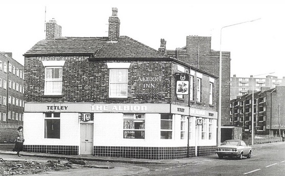
Originally the Irwell Inn in the 1860s, the Albion was a Walkers Brewery that stood on the corner of Irwell View and Ordsall Lane until the 1990s.  It originally had a plain corner door leading into the vault and a side door to the bar parlour before it was altered into the pub shown here.  When the Regent Road flats were being built (seen in the background, above), the Albion was under threat of demolition, but instead, Walkers extended the pub into the Irwell Place house next door and clad it in black and cream tiles.  The Albion was a Tetley's before it closed in 1990 and was finally knocked down a few years later [2].  Asgard Drive today marks the spot where the old Albion once stood.


Albion, Ordsall Lane, Salford. (c) Salford Pubs of the 70s at flickr [1].

2. Salford Pubs - Part Two: Including Islington, Ordsall Lane and Ordsall, Oldfield Road, Regent Road and Broughton, Neil Richardson (2003).

Pickwick Inn, Oldfield Road

Pickwick Inn, Oldfield Road, Salford, 1959. (c) Salford Pubs of the 70s at flickr [1].

The Pickwick Inn stood on the lower part of Oldfield Road on the corner with Zebra Street, opposite the Oldfield Road ironworks.  First recorded in 1871, the Pickwick belonged to Cronshaw's Brewery in the 1890s and Groves & Whitnall took over in 1899.  A year later the landlord, Thomas Jackson, was in trouble when the police accused him of allowing illegal gambling, and the use of a lookout on the door who would shout "Now gentlemen" or "Aye, aye!" to warn those inside playing dominoes of the approaching law.  Thankfully, they couldn't prove this and pub stayed open until 1976 when a fire led to its demolition [2].  Zebra Street has been lost to St Bartholomew's Drive today (googlemap link).

2. 1. Salford Pubs - Part Two: Including Islington, Ordsall Lane and Ordsall, Oldfield Road, Regent Road and Broughton, Neil Richardson (2003).

Sunday, 11 December 2011

Lochnagarr, Medlock Street

Lochnagarr, Medlock Street. (c) Bob Potts [1].

The Lochnagarr Inn was apparently named after a Scottish balled, 'Lachin y Gair' (although it could just as easily be after the Lochnagar mountains in the Grampains) by the Scottish licensee, Alexander Graham.  The pub had previously been known as the George the Fourth until 1851 [2] - the 1860 date on the pub sign may refer to a rebuild date of the Lochnagarr.  Opposite this Threlfalls boozer, which closed in 1934, was Walker's Yorkshire House.

1. The Old Pubs of Hulme & Chorlton-on-Medlock, Bob Potts (1997).
2. The Old Pubs of Hulme Manchester, Bob Potts (1983).

Yorkshire House, River Street


Yorkshire House, River Street. (c) Bob Potts [1].

This Walkers boozer had the odd feature of its sign spanning across the house next door on River Street.  The Yorkshire House was originally a Bell & Co. pub and closed in 1925 after it was compulsorily purchased by Manchester Corporation [1].  Facing the Yorkshire House was the Lochnagarr Inn across Medlock Street (right in the above photo).

Yorkshire House, River Street. (c) Bob Potts [2].

1. The Old Pubs of Hulme Manchester, Bob Potts (1983).
2. The Old Pubs of Hulme & Chorlton-on-Medlock, Bob Potts (1997).

British Standard, River Street

British Standard, River Street. (c) Bob Potts [1].

The British Standard is another Hulme pub lost beneath the Mancunian Way.  River Street once extended further west and met up with Great Jackson Street, itself which used to carry on south rather than sweep round and join City Road East.  The British Standard was on the south side of River Street, a couple of blocks before it met Great Jackson Street at a point known as Park Place which contained the Town's Weighing Machine (the Township of Hulme) [2].  The Threlfalls house was licensed from 1833 to 1934; the photo above is from the 1930s just before it closed [1].

1. The Old Pubs of Hulme Manchester, Bob Potts (1983).
2. Hulme 1844, Alan Godfrey Maps (2007).

Saturday, 10 December 2011

Hobsons Choice / Brown Cow, Oldfield Road

 -
Hobsons Choice, Oldfield Road, Salford. (c) Salford Pubs of the 70s [1].

Hobsons Choice stood on the corner of Cow Lane and Oldfield Road as a Whitbred house until 1999 when it was demolished, having closed in 1993.  Originally the Brown Cow, the beerhouse it opened in 1862 and was rebuilt by Chesters Brewery at some point.  As Chesters merged with Threlfalls, they were then taken over by Whitbread in 1968, who were responsible for the name change to Hobsons Choice in 1976 for its last 17 years.  The name Hobsons Choice probably comes from the famous 1954 film, set, as it was, in Salford, and possibly filmed nearby on Oldfield Road.  As is ever the case, nothing has been done to the site of the old pub since demolition.


Brown Cow, Oldfield Road, Salford. (c) Neil Richardson [2].

2. 1. Salford Pubs - Part Two: Including Islington, Ordsall Lane and Ordsall, Oldfield Road, Regent Road and Broughton, Neil Richardson (2003).

Thursday, 8 December 2011

Derby, Exbury Street


Derby Arms sign, Ladybarn Lane, Ladybarn. (c) Google 2011. View Larger Map

This old boozer has been converted into a residential properties for a number of years, although pleasingly, the pub sign has been retained as a feature outside on its pole on Ladybarn Lane.


Derby Arms sign, Ladybarn Lane. (c) Google 2011.

The Derby actually stood just behind here on Exbury Street off Mauldeth Road, parallel to Kingsway.  It is shown here to the rear on Exbury Street in 1959, 1970 and 1972 at the archives as a Wilsons house.


Former Derby, Exbury Street, Ladybarn. (c) Google 2011. View Larger Map.

Old House at Home, Braemar Road


Old House at Home, Braemar Road, Ladybarn. (c) Google 2011. View Larger Map.

This backstreet local's pub sadly closed in 2010 year and has recently been converted into accommodation.  The planning document laments the loss of the pub as "...regrettable as it represented a community facility that facilitated social cohesion [1]."  The Old House at Home was hidden away on Braemar Street, parallel to Moseley Road in between Wilmslow Road and Kingsway in Ladybarn.  There is a photo of the pub as a Greenalls house taken by Alan Winfield at Pubs Galore.

1. www.manchester.gov.uk/Braemar_Road_final.pdf.

Shakespeare, Philips Park Road

Shakespeare, Phillips Park Road, Bradford. (c) D.N. at ManMates Facebook [1].

The Shakespeare was a Chesters house at the junction of Forge Lane and Philips Park Road, back in the days when the latter used to run all the way from Miles Platting and through the area where the mini athletics stadium and the larger MCFC stadium is.  The archives has a 1971 photo of the Shakespeare from the Forge Lane side.

Shakespeare, Philips Park Road, Bradford. (c) Henry Bairsto [2].

The Shakespeare did brisk trade from the Richard Johnson & Nephew wire works situated in Forge Lane, but when the works and English Steel ceased, many of the pubs in this area of Bradford near the Colliery, suffered [2].  However, the Shakespeare survived and was still trading as recently as 1991 and I have vague memories of passing this pub, near to where the SportsCity flats are today.


Former location of Shakespeare, Philips Park Road. (c) Google 2011. View Larger Map.

1. www.facebook.com/ManMates.co.uk.
2. Just Henry - Memories of Bradford and Moston Collieries Manchester, Henry Bairsto (1991). 

Forge Tavern, Forge Lane

Forge Tavern, Forge Lane, Bradford. (c) Henry Bairsto [1].

The Forge Tavern was opposite the Bee Hive on Forge Lane (Alan Turing Way), near to the Bradford Pit entrance.  As such it was a popular place for miners and workers to sink a few pre- or post-shift pints; this time Wilsons rather than the Chesters available over the road.  Sadly, both these legendary Manchester ales are consigned to the slop tray of history...

1. Just Henry - Memories of Bradford and Moston Collieries Manchester, Henry Bairsto (1991).

Bee Hive, Forge Lane

Bee Hive, Forge Lane, Bradford. (c) Henry Bairsto [1].

The Bee Hive was right outside the entrance to the Bradford Pit, so would be full of miners who would have a quick shower after their shift then head for a pint of Chesters.  Morning workers would also pop in for a couple of pints before work (a more relaxed attitude to health & safety then) while the afternoon shift would have to convince the landlord to allow them a drink despite the restrictive opening hours [1].  There is a 1971 photo of the Bee Hive at the archives.

1. Just Henry - Memories of Bradford and Moston Collieries Manchester, Henry Bairsto (1991).