Pubs of Manchester

All pubs within the city centre and beyond.
A history of Manchester's hundreds of lost pubs.

Thursday, 8 November 2012

Mawson, Frances Street


Mawson, Frances Street, Brunswick. (c) Google 2012. View Larger Map.

Sadly the Mawson has recently closed after years of decline, despite its Grade II status [1] and its listing on the CAMRA Inventory of Historic Pub Interiors [2].  A rare survivor from the inter-war period, the Mawson has remained unchanged since 1936 while all around it has been demolished, rebuilt then neglected again in this depressed part of inner-city Manchester just north of Chorlton-on-Medlock.


Mawson, Frances Street, Brunswick. (c) British Listed Buildings.

The Mawson had been rebuilt by Tetley's Brewery to give a three-roomed public house (smoke room, ladies room and bar parlour) plus drinking lobby, and the tiled interior, screens, paneling and bench seating survive today.  There is also an off-sales area blocked up behind the bar [2]; this would have been used back in the day when many pubs offered take-away services.  Read and see more about the interior at CAMRA's Heritage Pubs site [2].


Mawson, Frances Street, Brunswick. (c) Google 2012. View Larger Map.

The Mawson Hotel dates back to the mid-to-late 19th century and originally only occupied a ground floor building on Frances Street where it fronted Clyde Street (now Cabot Street).  When it was rebuilt, incorporated two neighbouring houses in this largely Irish area [1].  The new Brunswick and Kincardine estates can be seen going up in 1970 and 1972 around the Mawson.  Sadly we didn't get chance to visit the Mawson before it closed, but the lack of decent beer on offer didn't help.  It now looks like this historic old boozer will go the way of the nearby Kings Arms.

1. www.britishlistedbuildings.co.uk/en-507794-the-mawson-hotel-.
2. www.heritagepubs.org.uk/pubs/national-inventory-entry.asp?pubid=74.

Tuesday, 30 October 2012

White Swan, Green Street

White Swan, Green Street, Ladybarn. (c) thisiswhereiamthisiswhereiwas.

The White Swan, known locally as the 'Mucky Duck', was sold by Robinson's in 2011 and closed without much ceremony late that year.  2012 has brought better news as the local Ladybarn Social Club (the former British Legion) has apparantly bought it as of October [1].  There are plans to reopen the White Swan and hopefully go someway to restoring what was once a fine public house with a traditional interior.  

White Swan, Green Street, Ladybarn. (c) Eccles Express at gostreet.

CAMRA reports that some of these original features - the etched glass and carved wood bar - are gone, but the ceramic tiling, etched off-sale sign and ornate toilets remain.  The side entrance's 'outdoor' sign also remains and below are one of many bands who played in the White Swan's upstairs venue called Creative Space.

White Swan, Green Street, Ladybarn. (c) Phil Portus.

The vault and a front room have been closed for years so only the main bar had been serving to a small but loyal band of locals (and music fans for the Friday night shows which ran since the 1980s).  There is a wonderful blog post at thisiswhereiamthisiswhereiwas describing the White Swan and her locals:

It's a quiet, almost abandoned pub that doesn't even look like it's open.  It reminds me of the Winchester from Shaun of the Dead, but without customers.  It does have some customers though.  My favourites are Pat... a lovely Irish man with a great, grey tash who always refers to Manchester United as the "Red Machine".  He drinks 2 pints of lager at the same time.  Joe is also a smashing Irish chap whose shirt is always way too wide open revealing a large chest that has seen one too many bitters and whiskeys...
 
White Swan, Green Street, Ladybarn. (c) toppictures.

There are reports that the White Swan will indeed be reopening its doors under the Ladybarn Social Club in early 2013 after some minor refurbishments.  We look forward to visiting this soon-to-be-reborn Manchester classic...


White Swan, Green Street, Ladybarn. (c) Eccles Express at gostreet.

1. www.camrahops.com/guide/004000/Pub004518.htm.
2. http://thisiswhereiamthisiswhereiwas.blogspot.co.uk/2011/05/white-swan-pub-ladybarn-manchester-m14.html.

Friday, 26 October 2012

205. Parlour, Beech Road


Parlour, Beech Road, Chorlton-cum-Hardy. (c) The Parlour.


Parlour, Beech Road, Chorlton-cum-Hardy. (c) The Parlour.


Website: http://theparlour.info

 
Marmalde, Beech Road, Chorlton-cum-Hardy. (c) Adam Bruderer at flickr.

204. Trevor Arms, Beech Road


Trevor Arms, Beech Road, Chorlton-cum-Hardy. (c) Original Pub Company.


Trevor Arms, Beech Road, Chorlton-cum-Hardy. (c) British Real Ale Guide.


Trevor Arms, Beech Road, Chorlton-cum-Hardy. (c) Tony Walker at Andrew Simpson's Chorlton History [1].

1. http://chorltonhistory.blogspot.co.uk/2012/07/picture-day-trevor-arms-circa-1910.html.

Tuesday, 23 October 2012

Waggon & Horses, Stockport Road


Waggon & Horses, Stockport Road, Longsight. (c) TBC - please email!

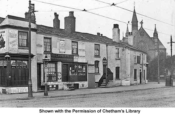
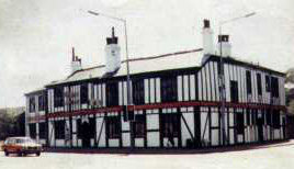
The Waggon & Horses was a famous old landmark pub stood at the meeting of Plymouth Grove, Birch Lane and Stockport Road and was only demolished a couple of decades ago.  Under controversial circumstances, reminiscent of the even more famous Tommy Ducks, the Waggon & Horses with its false timbered frontage was pulled down under the dead of night and has been replaced by an uninspiring block of flats.  The pub, shown here in a Chetham's Library image at Manchester History [1], was in the shadow of the Longsight Free Christian Church (also demolished), and its adjoining shops had far more character.

Former location of Waggon & Horses, Stockport Road. (c) Google 2012. View Larger Map.

The Waggon & Horses can be traced back to 1690 when a pub was first recorded here.  The whitewashed pub shown in this old photo from 1900 was built a century or two later, and this postcard from a few years later shows how owners, Wilsons Brewery, incorporated the next door house on Birch Lane.


Waggon & Horses, Stockport Road. (c) TBC - please email! 

In the 1900 photo you can see the  200-odd-year-old mounting stone on the corner of Birch Lane, and it is shown close up here in 1969 and 1971.  By this time, Wilsons had added the timer facade as seen in 1970 and on the 1983 photo from Mick Regan at Manchester History [1].


Waggon & Horses, Stockport Road. (c) TBC - please email! 

A PLEA - I have lost the details of the person who kindly sent these pictures.  Please email!

Sunday, 21 October 2012

Seymour / Grove, Upper Chorlton Road

Grove, Upper Chorlton Road, Whalley Range. (c) Tim Martin with kind permission.

When the Grove on the corner of Seymour Grove and Upper Chorlton Road was demolished in 2002 it was still widely known as the Seymour. The grand old building is shown at the archives in 1956, side-on in 1959,  from the front showing its huge size in the 1960s, in the '70s, and twice in 1973.  

Seymour, Upper Chorlton Road, Whalley Range, 2002. (c) MEN.

The huge size of the Seymour actually stems from the fact it was originally a private house half the size. When it was turned into a pub it was doubled in size so that it was a mirror image of itself. A fire in the early 2000s led to the pub's closure and demolition, and the land was sold to developers who have replaced it with ugly new flats. 

Seymour, Upper Chorlton Road, Whalley Range, c.1955. (c) Francis Frith.

The Seymour is infamous for being close to where a policeman was killed back in 1876. This plaque on the wall in this 1924 photo marks the spot where local villain, Charles Peace, shot dead a copper, PC Cock, and his grave is sited in Chorlton Green today.

Former location of Seymour / Grove, Upper Chorlton Road, Whalley Range. (c) Adam B. at flickr.

Throstles Nest, Seymour Grove


Throstles Nest, Seymour Grove, Old Trafford, 2011. (c) Adam B. at flickr.

This once-popular local's boozer on the Old Trafford - Whalley Range border closed down in 2010.  The Throstles Nest was also a match day boozer for Man Utd fans but despite this it has gone the way of so many inner city alehouses.

Throstles Nest, Seymour Grove, Old Trafford, 2011. (c) Adam B. at flickr.

The Throstles Nest is next door to the Old Trafford Conservative club on Seymour Grove, and is still shown as open in 2009 on Google streetmaps.


Throstles Nest, Seymour Grove, Old Trafford, 2009. (c) Google 2012. View Larger Map.


Throstles Nest, Seymour Grove, Old Trafford, 2009. (c) CAMRA.

Sunday, 14 October 2012

Duke of York, Duke Street

Duke of York, Duke Street, Lower Broughton. (c) Salford Pubs of the 70s at flickr [1].

The Duke of York was an old grocer's shop with a beer licence by 1880, before Boddington's Brewery took over in the early 1900s and it eventually became fully licensed.  As part of Lower Broughton's redevelopment in the 1970s and '80s, the Duke of York was ordered to close in 1979, closed a year later and was pulled down shortly afterwards [2].  The evocative photo above shows a horse and cart, a smartly-dressed black chap and what may be the landlord and landlady at the pub steps.  Duke Street still runs through this part of Salford, but the site of the old Duke of York was just south of Lord Street (then named Victoria Street) on the east side.

2. Salford Pubs Part Two: Including Islington, Ordsall Lane and Ordsall, Oldfield Road, Regent Road and Broughton, Neil Richardson (2003).

Cross Keys, Garden Street


Cross Keys, Garden Street, Lower Broughton, 1974. (c) Salford Pubs of the 70s [1].

Situated between Lower Broughton Road and the River Irwell, the Cross Keys opened in 1875 on the corner of Eliza Street and Garden Street.  Threlfalls Brewery had the Cross Keys before it passed to Whitbread in the 1960s.  It escaped demolition in the first Lower Broughton compulsory purchase scheme of 1967 but by the mid-'70s it had closed and been pulled down [2]. 

Cross Keys, Garden Street, Lower Broughton. (c) Neil Richardson [2].

2. Salford Pubs Part Two: Including Islington, Ordsall Lane and Ordsall, Oldfield Road, Regent Road and Broughton, Neil Richardson (2003).

Prince of Wales, Lever Street

Prince of Wales, Lever Street, Hulme (background, left). (c) Hulme, CoM, All Saints, Ardwick Facebook.

Not to be confused with the Prince of Wales on the corner of Lever Street (Warwick Street) in town, this Hulme boozer was on the corner of Bold Street and Lever Street just off Upper Moss Lane.  Shown in the background as the pale-coloured building in the above photo, The Prince of Wales was at No.17 and opened in 1848 [1].  Cronshaw's Brewery had the beerhouse then it passed to Groves & Whitnall before it closed in 1965 [2].

1. The Old Pubs of Hulme Manchester (1) 1770-1930, Bob Potts (1983).
2. The Old Pubs of Hulme & Chorlton-on-Medlock, Bob Potts (1997).

203. Horse & Jockey, The Green


Horse & Jockey, The Green, Chorlton-cum-Hardy. (c) Horse & Jockey.


Website:  www.horseandjockeychorlton.com.


Horse & Jockey, Chorlton Green, Chorlton-cum-Hardy. (c) Horse & Jockey.

202. Bowling Green, Brookburn Road

Bowling Green, Brookburn Road, Chorlton-cum-Hardy. (c) Adam Bruderer.


201. Magnet, Wellington Road North

Magnet, Wellington Road North, Stockport. (c) leebodiham at qype.


Magnet, Wellington Road North, Stockport. (c) leebodiham at qype.

Saturday, 13 October 2012

Russell Social Club, Russell Street

Russell Social Club, Russell Street, Hulme. (c) Hulme CoM, All Saints, Ardwick Facebook.

The celebrated Russell Club, later known as the PSV (Public Service Vehicle) Club, The Factory and the Caribbean Club, was built to replace this ramshackle old place, the Russell Social Club.  The new Russell Club on Royce Street was as big as the old Russell Street one, but more brutal in its design than the original. 

Factory Club, Royce Road, Hulme. (c) Kevin Cummins at Richard Goodall Gallery [1].

Thursday, 11 October 2012

Albert Hotel, Whit Lane


Albert Hotel, Whit Lane, Salford, 1973. (c) Salford Pubs of the 70s at flickr.

The Albert Hotel was a Joseph Holt's house on Whit Lane known locally as Tush's.  It closed in 1973 (same year as the photo, above) under the compulsory purchase order and was demolished soon after.  The first licensed house on this corner of Indigo Lane and Whit Lane was known as the Live & Let Live, a beerhouse which dates back to the 1860s.  The name was changed to the Friendship Tavern, and when a full licence was gained the public house was renamed the Albert Hotel, claimed to be one of the largest in the area.  The Albert Hotel became a Holt's house in 1909 with its huge advert for their beers, wines and spirits on the Indigo Street side [2].

1. www.flickr.com/photos/61756486@N05.
2. The Old Pubs of Salford Part Three: Including Cross Lane, Broad Street, Hanky Park, the Height, Brindleheath, Charlestown and Weaste, Neil Richardson (2003).

Sunday, 30 September 2012

Eagle, Stretford Road


Eagle, Stretford Road, Hulme. Anthony Scally at Ex Hulme facebook.

This Eagle opened in  1837 and was a Walker & Homfray house [1], closing as a Wilsons house in 1968 [2] when Hulme underwent its first regeneration.  It was on the corner of Upper Moss Lane and Stretford Road and today some pleasant looking flats sit on the site of the old pub.  However, the Eagle did live on after its demolition, as the estate pub of the same name was built on nearby Robert Adam Crescent, lasting only a couple of decades before being swept away along with the disastrous Hulme Crescents.

Eagle, Stretford Road, Hulme. (c) Google 2012. View Larger Map.

1. The Old Pubs of Hulme Manchester (1) 1770-1930, Bob Potts (1983).
2. The Old Pubs of Hulme & Chorlton-on-Medlock, Bob Potts (1997).

Friday, 28 September 2012

Dog & Partridge, Bolton Road


Dog & Partridge, Bolton Road, Irlams O'Th' Height. (c) Google 2012. View Larger Map.

The Dog & Partridge closed about 4 years ago after two shooting incidents in as many months.  Ironically this old Bass house is now in use as a doctor's surgery, The Height General Practice.

Dog & Partridge, Bolton Road, Irlams O'Th' Height. (c) SSP Health.

This end of Salford is known as Irlams O'Th' Height, so named after the Irlam family who ran another pub nearby, the Pack Horse, and because as it stands at the head of the Irwell Valley.


Dog & Partridge, Bolton Road, Irlams O'Th' Height, 1973. (c) Salford Pubs of the 70s at flickr [1].

Until its closure, this stretch of Bolton Road boasted a hattrick of pubs - the Wellington, Dog & Partridge and the Waggon & Horses.  It is telling that the Pub Co-owned boozer was the one to go, while the two Joseph Holt estate pubs survive.


Wellington, Dog & Partridge, Waggon & Horses, Bolton Road, Irlams O'Th' Height. (c) Google 2012. View Larger Map.

1. www.flickr.com/photos/61756486@N05.

Tuesday, 25 September 2012

Pop Inn, Platt Lane


Former Pop Inn, Platt Lane, Rusholme. (c) Google 2012. View Larger Map.

Above what used to be a Co-Op on the corner of Yew Tree Road and Platt Lane was Co-Op Hall, a dance venue that was opened as the Pop Inn in the swinging sixties.  Originally the Pop Inn was unlicensed like many of Manchester's clubs, but in later years it became licensed to try to boost attendances.  The entrance to the club was actually on Yew Tree Road, and the double doors led to a neon-lit staircase which was wallpapered with a floral, puce effect.  The tunes were Motown, Rhythm 'n' Blues and Pop, and an early style of line-dancing was practiced here by the youthful revellers [1].  

Former Pop Inn, Platt Lane, Rusholme. (c) Google 2012. View Larger Map.

The 1960s and '70s City players who used trained opposite here at the Platt Lane training ground in Rusholme were probably more interested in visiting the pubs and clubs in the city centre than a teetotal line-dancing club.  These days the Co-Op is now a continental supermarket and the old entrance has details of the Muslim community centre which is now housed here.  While the Pop Inn probably closed in the '70s, MCFC still have a presence here with the youth teams based at Platt Lane, but not for long as they will soon be relocating to the new Etihad Campus at Clayton Arm.

1. www.manchesterbeat.com/venues/rusholme/popinn/popinn.php.

Monday, 24 September 2012

Hulme Labour Club, Bonsall Street


Hulme Labour Club, Bonsall Street, Hulme, 1995. (c) Mick Pye with kind permission.

Looking grim here in the mid-1990s, the Hulme Labour Club is shown at the archive in happier times just after it opened, in 1971 as part of the new, regenerated Hulme.  Why the council or the owners eventually decided to brick up the windows is rather obvious when the disturbing history of this disastrous 1970s Hulme redevelopment is considered.  The Hulme Labour Club played host to famous bands back in the day, such as The Fall in 1977 and Fast Cars the following year.  However, by the mid-'80s the place had closed and was being used as a squat, perhaps by the sort of chaps shown below (it's "Dave Hulmanoid" with the hat).

Hulme Labour Club, Bonsall Street, Hulme, mid-'90s. (c) Mick Pye at Manchester District Music Archive [1].

Digging through the archives brings up this sorry story from 1982 in The Tribune:  "AT AN election night social in the Hulme Labour Club in May, two gay men suffered an unprovoked attack which resulted in both of them requiring hospital treatment.  The club, which has a long record of discrimination against gay people, has refused to condemn the attack or take any action against the attacker whose identity is widely known as a member of Hulme Labour Club.  Hulme Labour Party has now decided to break all connections with the club and will picket it every Friday evening."  Bonsall Street still spans Princess Road today, just south of Stretford Road; the club is, of course, gone.

1. www.mdmarchive.co.uk/archive/showartefact.php?aid=8607&vid=631.

Wednesday, 19 September 2012

Church Inn, Palmerston Street

Church Inn, Palmerston Street, Ancoats. (c) Neil Richardson [1].

On the corner of Russell Street and Palmerston Street, the Church Inn was a Groves & Whitnall house that lasted until 1966.  It was known locally as "Bill Illingworth's", the landlord, who was also a partner in Illingworth & Ingham's builders of Old Trafford [1].  The old location of the Church Inn is roughly where the pin is on this modern day map of Palmerston Street on the Ancoats / Beswick border.

1. The Old Pubs of Ancoats, Neil Richardson (1987).

Clarence, Slater Street

Clarence, Slater Street, 1920s. (c) Bob Potts [1].

The Clarence was the last pub standing on Slater Street before the properties were all bought up and knocked down under a 1960s Compulsory Purchase Order.  The Clarence was a Threlfalls house that stood  here just off Rochdale Road from 1851 to 1964 [1].  The street still runs through this part of inner city north Manchester (just about Collyhurst) today but has been renamed Sudell Street.

1. The Old Pubs of Rochdale Road and neighbourhood Manchester, Bob Potts (1985).