Pubs of Manchester

All pubs within the city centre and beyond.
A history of Manchester's hundreds of lost pubs.

Monday, 8 November 2010

Fifteenth Hussar, Portland Street


Former location of Fifteenth Hussar, Portland Street. (c) googlemaps.

In the mid-1800s the Fifteenth Hussar stood on Portland Street, with an entrance to the rear on Reyner Street, before it was replaced by this warehouse.  The pub was second from the end of this stretch of Portland Street before Charlotte Street, so its exact site would probably have been where the Bella Roma Italian restaurant is [1].


Former location of Fifteenth Hussar, Portland Street. (c) googlemaps.

1. Manchester City Centre 1849, Alan Godfrey Maps (2008).

Gibraltar Hotel, Back Pool Fold

Former location of Gibraltar Hotel, down Back Pool Fold (c) manchesterinpictures.

Tucked down the side of Sam's Chop House is Back Pool Fold.  Down here and to the right, in the dim and distant past, stood the Gibraltar Hotel [1].

1. Manchester City Centre 1849, Alan Godfrey Maps (2008).

Wellington Inn, Peter Street

Theatre Royal / Discotheque Royales, Peter Street, 2009 (c) Arthur Lloyd.

The Wellington Inn used to stand next to the second Theatre Royal on Peter Street, which burnt down on 7th May 1844.  The proprietors sold the land on which it stood to John Knowles who decided that he would build a bigger and better theatre.  To do this he had to knock down the adjacent Wellington and Brogden's horse bazaar.  The third Theatre Royal was opened the following year and the likes of Charles Dickens, John Leech and George Cruickshank appeared to crowds of a few thousand in this fine building next to the Free Trade Hall [1].  It became a cinema in 1929 and by 1972 it was a bingo hall before it lay empty for some years [2].  In 1989 it was reinvented as Discotheque Royales, a venue which probably kick started Peter Street as the place to go for a cheesy and drunken night out (guilty).  Pleasingly, Royales is no more and the Theatre Royal is back to its proper use - see Arthur Lloyd's Theatre History site for a couple of photos of rehearsals taking place in summer 2010 [2]. 

Theatre Royal / Discotheque Royales, Peter Street. (c) swjmoore at skyscrapercity.

1.  Manchester Streets and Manchester Men, Thomas Swindells (2008).
2.  www.arthurlloyd.co.uk/ManchesterTheatres/TheatreRoyalManchester.htm.

Packhorse, Market Street

Back in the days when Cross Street was nothing more than a covered passage leading off Market Street, the Packhorse stood on the right handside off the passage as you passed down Market Street towards Deansgate.  Described as of quaint appearance, the Packhorse was run by John Frost in the 1800s [1].  The pub was lost when Cross Street was made into a more substantial street some time before the middle of the 19th century.

1. Manchester Streets and Manchester Men, Thomas Swindells (2008).

Peacock, Market Street

The Peacock used to stand on Market Street where Cross Street passes it today.  In the early 1800s it was kept by John Knowles, and it was a coaching house where the famous Peveril of the Peak (the Pev itself is named after this vehicle) coach set out from in its last days [1].

1. Manchester Streets and Manchester Men, Thomas Swindells (2008).

Royal Oak Tavern, Spring Gardens

On the opposite east corner of Market Street and Spring Gardens to the Rainbow Hotel was the Royal Oak Tavern, last recorded in 1822 [1].

1. Manchester Streets & Manchester Men, Thomas Swindells (2008).

Saturday, 6 November 2010

Guest Pub - Brovaria, Stary Rynek, Poznań

Brovaria, Stary Rynek, Poznań. (c) Pubs of Manchester / ticktock.

The most recent stage of our ongoing tour of Europe took us to Poznań, Poland.  Upon leaving the match we faced an unappealing schlep to the old market square through a city whose suburbs looked to us as being astonishingly devoid of watering holes for the thirsty traveller.  Fortunately we managed to flag down a taxi and after a few twists and turns to avoid the horrendous traffic we arrived at our destination.

Brovaria, Stary Rynek, Poznań. (c) Pubs of Manchester / ticktock.

Brovaria is a rather upmarket and very busy brew pub right on the main square, Stary Rynek.  Location and status are reflected in the prices and we settled on the Brovaria Miodowe.  At 9 złoty (a little over £2 at current exchange rates) for a ‘Maximillian’ (about a pint) it was still hardly breaking the bank.  We settled in the smaller ground floor bar area and enjoyed several drinks and conversation with the friendly locals.  The pride and passion that the Lech supporters showed during the match was mirrored by the generosity and graciousness they showed to the visiting Mancunians in here.

Brovaria, Stary Rynek, Poznań. (c) Pubs of Manchester / ticktock.

The Miodowe (honey) beer is brewed on the premises in the establishment’s own microbrewery with a small selection of other beers.  The brewing vats themselves are a feature of the large upstairs bar area.  Modern, bright and shiny, they are constructed so as to avoid producing the all pervading smell of the brewer’s craft that can sometimes detract from a trip to such a place.  Although the equipment is modern, the techniques used to brew the nectar are ancient.  The beer is naturally clouded, has flavour and body and is a proper ale, far removed from the ‘fizzy lager’ served up in many British and continental pubs.

Brovaria, Stary Rynek, Poznań. (c) Pubs of Manchester / ticktock.

The pub has a restaurant area with food at very reasonable prices but as this was completely separate it did not interfere with the drinking experience.  The address dates back to the 15th Century but the current building was completed as late as 1955 having been rebuilt after the war with respect to history and architectural traditions with Brovaria opening its doors in 2004.

Brovaria, Stary Rynek, Poznań. (c) Pubs of Manchester / ticktock.

Tuesday, 2 November 2010

133. New York New York, Bloom Street

New York New York, Bloom Street. (c) Their Facebook.

The last of the proper pubs we're covering in the Gay Village (the rest are bars or clubs and from limited past experience, are rarely inclusive and offer nowt in the way of decent ale).  Back in the day, when the Village didn't really exist, it was a Wilsons house called simply the New York as shown here in the 1950s, here in the '70s and here in 1986 ("Foster's Lager the Australian Pint").  These days a plush conversion has turned the old ale house into a reasonable bar.  Pleasingly some ale was on offer, even it was only bottles of Newcy Brown, but that's better than nothing.  The friendly and suitably camp bar staff were happy to serve half a dozen of us in the quieter vault.

132. New Union, Princess Street

New Union, Princess Street. (c) tripadvisor.

Two gay pubs left to do, and the first of these was the New Union, which in fact looks anything like the stereotyped gay pub you would expect.  Big open pub with central bar area and pool room to the right as you walk in, we were pleasantly welcomed by most without issue.  That was though all except one flouncing queen in the corner who kept grumbling and mumbling all the time we were there about straights being "in "his pub."  This despite a few straight couples also enjoying a drink out of plastic pots (a rather off-putting policy I must say).

As it is, the New Union is a pleasant enough pub, despite its lack of real ale, which clearly appears to be something of a no-no with the gay community for some reason.  One can only assume their tastes and palates are somewhat different to us when it comes to ale.  We just had the one and got off though, because as much as it was funny to annoy the corner whinger, it really wasn't for us.  The pub probably goes back to the 19th century and was the Union Hotel in the 1970 as seen in these two photos from the Archive.

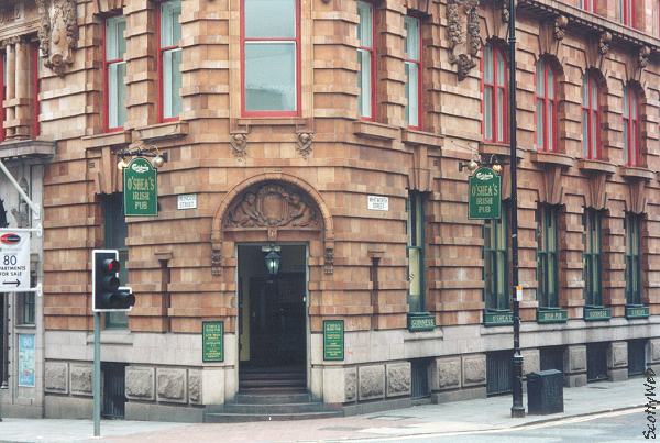
131. O'Shea's, Whitworth Street

O'Shea's, Whitworth Street. (c) scottyweb.

Typically Irish pub and just like Mulligans, is at least filled with some Irish people and staff.  Now then, the theme here is of course unmistakeably that of the Emerald Isle, so it is, and it's fine if that's what you're into.  If it's not, then there are far better options in town for a few pints.  The pub iself is a large single-roomed affar with a stage area at one end for live music.  A bar traverses the entire length of one side of the premises, and there are usually no shortage of staff waiting to take your order.  In saying that for all the "Irish charm", it's just a little bit too much if you're not of that persuasion.

I would point however that I've never felt uneasy or threatened in anyway in here and it's OK for a quick one or two (and real ale is on offer in the form of Black Sheep), rather than maybe a whole night here, it's just better if you're Irish (or a united fan) methinks.  Give me the nearby Lass, Thirsty Scholar or Salisbury any day!

130. Revolution, Oxford Road

Revolution, Oxford Road (c) prideofmanchester.

The second of our Revolution bars - there are three in total (and we don't intend to cover the Deansgate Locks branch!).  Whilst an improvement on the first one off Deansgate (wouldn't be difficult), it's still a strangely sterile world of expensive drinks and little atmosphere.  Once again, no sign of real ale, so it was Guinness or a bottle of foreign lager to numb the palate, and whilst sitting in the window was nice to do a bit of people watching, it doesn't match the feel of a good pub.  As is the way with this and other dull chain bars, they have their niche and their regular customers, it's just not for us!

129. Base Rock Bar, Charles Street

Base, Charles Street (c) sugarvine.

Base is "an independent basement HD sports bar with a rock 'n' roll soundtrack, doing our own thing in the face of the multi-national corporates".  With an Indian café site above in the old Po-Na-Na venue (bring your food down, I believe) and offering reasonably priced drinks, Base is clearly after a bit of the local student market as well as football fans.  The bar isn't entirely noticeable from outside on Charles Street down the side of the BBC, and but for our many trips to the next door Lass O'Gowrie, we may never have known of its existence.  The proximity to the FAC 251 club must help in this regard and it's something of a pre-club venue for those who prefer a bar to the traditional of the Lass.


Base, Charles Street (c) sugarvine.

The barman was a welcoming chap and the place has a good feel to it, albeit pretty empty for a Saturday early evening (and united on the telly), so we stayed for a couple.  Inside was spotlessly clean as were the toilets and the fittings and fixtures are comfortable.  Lack of real beer was a disappointment and the serving of Guinness in cans was initially puzzling, though this was somewhat tempered by the Guinness ultrasonic livening machine which was a good trick.  Though probably not enough to entice us back again but definitely one for the youngsters and students of Manchester!

Follow Base on Twitter @base_rock_bar and on Facebook.

128. Salutation, Higher Chatham Street


Salutation, Higher Chatham Street. (c) salutationpub.

A quick wander across Oxford Road, past the Royal Northern College of Music (their canteen wasn't for us, even if it does allegedly serve real ale) and round the corner sits the Salutation.  A fine old Victorian pub sat behind the 1960s monoliths of Oxford Road, and a friendly little place as well.  Beer selection was a bit limited with only Timothy Taylors Landlord on, but there was another pump which was "off today."

The pub itself is really one big room, linked around a central bar with a small beer garden at the back. With its location, it might put you off searching out, but don't because its a fine little place.  Just needs more choice!  General clientele was a bit mixed with a few beardies in when we arrived, a few of the local "characters" out the back, and the odd student popping his head in.  Presumably it's a busier student haunt at night time, judging by the various events planned with cheap or free shots one of the main attractions.

Monday, 1 November 2010

Flying Horse / Angel Hotel, Market Lane (Street)

Manchester Streets and Manchester Men, Thomas Swindells (2008).

In the early to mid 1700s Market Stead Lane or Market Lane (Market Street these days) had ten inns - the Fountain, Anchor, Cock, Upper Swan, Bear's Paw, Royal Oak, Flying Horse, Pack Horse, Bellman and the Lower Swan [1].  Most were lost during widening of the street by the end of the century, but one which survived well into the 1800s was the Flying Horse.  Described in Manchester Streets and Manchester Men  in 1822 as four doors past High Street (on the left going towards Piccadilly), the Flying Horse was an occasional starting point for stage coaches travelling south [1].  The same passage reveals that in the early 1800s Tib Street was known as Stable Street, maybe on account of said coaches.  The 1849 map shows that the Flying Horse later became the Angel Hotel, just opposite the Talbot Hotel and its adjoining Talbot Hotel Tap [2].

1. Manchester Streets and Manchester Men, Thomas Swindells (2008).
2. Manchester City Centre 1849, Alan Godfrey Maps (2008).

127. Deaf Institute, Grosvenor Street

Deaf Institute, Grosvenor Street. (c) largemanchester.

Leaving The Pub, it was quick stroll across to the music venue that is the Deaf Institute, and into the downstairs bar and eating area.  This is a sister bar to Trof in the Northern Quarter, and as such persists with an equally outrageous pricing system. But in saying this, it doesn't seem to put the local students off spending their hard earned student loans in here.  It's no wonder some of them rack up such debts if they drink in places like this.

The bar itself however is friendly and welcoming but does feel a little bit too café-ish if I'm honest.  The staff were attentive, and discussed the available drinks with us and warned us when we had selected the £5.50 a pint Blue Moon.  The overall beer selection is plentiful, with draught lagers and American ales available and a good bottled selection, albeit a pricey one.  There is a glaring lack of real ale though, either on pump or in bottled format which is something of a shame.  We tried a pint of keg Brooklyn ale, which was very nice, though at £4 a pint is a bit steep when you're on a session. 

As with The Pub, I wouldn't put anyone off as it's a nice little bar with decent low-key tunes, but make sure you've got deep pockets.  When this place first opened a few years ago it was known as the Deaf & Dumb Institute, as the old building itself has always been, but decided to change to the more politically correct shortened name.

Website:  www.thedeafinstitute.co.uk.

126. The Pub, Grosvenor Street

The Pub, Grosvenor Street. (c) beerintheevening.

Our planned starting point of the Sandbar on Grosvenor Street, was unfortunately closed at 12.20 on a Saturday lunch time (poor show) so we had to make do with next door at The Pub.  This is a strange venue, quite cavernous in looks, and reminded me very much of a Wetherspoons but without the vagrants (and did used to be an Irish themed pub in the past, Scruffy Murphy's).  Despite this, the bar staff were friendly and there were three real ales available, London Pride, Black Sheep and Marstons Pedigree.  With some degree of trepdation we plumped for the London Pride, however we should not have worried as it turned out to be an excellent drop and all the better for being sparkled in the Northern manner.  Whilst possibly not our choice of ideal pub, it wasn't bad for starting off point and I'm sure its popular with the local student population.  Certainly wouldn't want to put anyone off, worth a try, if only for a couple.

Sunday, 31 October 2010

Stone Masons Arms, Cambridge Street

Former location of Stone Masons Arms, Cambridge Street. (c) googlemaps.

Across the road from the JW Lees house, the Church Inn, on Cambridge Street just off the Mancunian Way, used to stand the Stone Masons Arms [1].  It stood roughly in the gap between the trees and building in the above picture where the lost Whittaker Street used to run.

1. Hulme 1844, Alan Godfrey Maps (2007).

MMU Student Union, Lower Ormond Street


Former MMU Student Union, Lower Ormond Street. (c) googlemaps.

The Grade II Righton Building on Lower Ormond Street was originally the drapery shop of William Righton, built in 1905.  Till & Kennedy iron mongers took it over from 1955 to 1969, when it became the Manchester Metropolitan University Student Union compete with subsidised bar [1].  


Righton Building, Lower Ormond Street. (c) googlemaps.

The ornate terracotta tiling is suggestive of a fine old boozer, but that it was not built as one, is simply testament to the quality of building work back in the day.  Indeed, across the road, the ugly 1960s towers are being pulled down to make way for the huge student accommodation tower.  These days the Righton Building is home to the University Events office and the History of Art & Design department [2].


Former MMU Student Union, Lower Ormond Street. (c) googlemaps.

1. Manchester: an architectural history, John J. Parkinson-Bailey (2000).
2. http://en.wikipedia.org/wiki/MMUnion. 

Scubar, York Street

Scubar, York Street (from Oxford Road). (c) Pubs of Manchester.

Just off Oxford Road on York Street in the shadow of the Manchester Aquatics Centre sits the recently closed Scubar.  It was previously known the Old Steam Brewery and Green McNally's Sports Bar, when it was a very occasional post-match port of call.  In its later years it was a studenty cocktails bar, but did occasionally have real ales on.  Unlike its sibling, the lost Scu 2 Bar which lives on as the Courtyard, there appears no chance that life will be breathed back into this venue - a sign on the door says it's being turned into a place of worship.


Scubar, York Street (from Grosvenor Street). (c) Pubs of Manchester.

Friday, 29 October 2010

CAMRA's Pub Staggers of Manchester

As it's the SIBA Great Northern Beer Festival here in Manchester this weekend, here's to Manchester's CAMRA branches who, in conjunction with Visit Manchester, have pulled together a handful of Manchester Pub Staggers.  Each one takes in half a dozen of our finest pubs, and of course, every one serves decent real ale.


1. Download (start Victoria Station) Crown & Cushion - Hare & Hounds - Smithfield Hotel - Bar Fringe - Angel - Marble Arch

2. Download (start Piccadilly Station) Bulls Head - Jolly Angler - Waldorf - Seven Oaks - Grey Horse - Circus Tavern - Old Monkey

3. Download (start Deansgate Station) Deansgate - Sir Ralph Abercromby - Rising Sun - Ape & Apple - Town Hall Tavern - Vine Inn

4. Download (start Oxford Road Station) Salisbury - Lass O'Gowrie - Peveril of the Peak - Briton's Protection - City Arms - Shakespeare

5. Download (start Piccadilly Station) Jolly Angler [again!] - Crown & Anchor - Castle - City - Wheatsheaf - Crown & Kettle

(c) SIBA.

Thursday, 28 October 2010

Coach & Horses, Todd Street

Former location of Coach & Horses, Todd Street (Corporation Street). (c) googlemaps.

Across Clock Alley from the White Lion on Todd Street was the Coach & Horses [1].  It was a narrow pub which had a curved frontage down the alley and its old spot was just about where the Co-Op entrance is on Corporation Street.  Tucked away down the dead-end of Clock Alley were some of the dreaded back-to-back and court dwellings in the mid-1880s [1].

1. Manchester Victoria 1849, Alan Godfrey Maps (2009).

White Lion, Todd Street

Former location of White Lion, Todd Street (Corporation Street). (c) googlemaps.

To the left of the Corporation Street side of the Printworks is a new Co-Op building, and the right part of this covers where the White Lion pub used to sit.  Clock Alley was to the left and to the right of the pub was the Coronation Steam Corn Mill [1].  Across Clock Alley was the smaller Coach & Horses pub.

1. Manchester Victoria 1849, Alan Godfrey Maps (2009).

Commercial Inn, Sugar Lane

At No.17 Sugar Lane, a lost street known best for the Sugar Loaf, was the Commercial Inn, as detailed in this 1911 census from the licensee, Benjamin Barker. The 1849 map confirms its location at the bottom of Sugar Lane just before it turned into Duke Street (which later became the top, Shudehill end of New Brown Street) [1]. 

1. Manchester Victoria 1849, Alan Godfrey Maps (2009).

White Hart Inn, Sugar Lane

On the short Sugar Lane that used to run off Withy Grove stood the White Hart Inn as seen on the 1849 map [1], also listed in the 1825 directory.  Sugar Lane, seen in 1977, and its last pub, the Sugar Loaf, were lost when the Arndale monstrosity was built in the 1970s.

1. Manchester Victoria 1849, Alan Godfrey Maps (2009).  

Higher Ship Inn, Shudehill

Former location of the Higher Ship Inn, Shudehill. (c) googlemaps.

Just five doors up from the Lower Ship on Withy Grove, and a few doors down from the famous Rovers Return and the Mosley Arms was the Higher Ship Inn in the mid 1800s [1].  Sadly for the Higher Ship, its old site is now taken by a Gregg's. 

1. Manchester Victoria 1849, Alan Godfrey Maps (2009).

Wednesday, 27 October 2010

Clarence Hotel, Clarence Court

Former location of Clarence Hotel, Clarence Court (4). (c) Alan Godfrey Maps [1].

Before the Arndale and the redevelopment of both sides of Market Street, the Manchester Borough Court Houses straddled Spring Gardens and Brown Street on the left as you go down Market Street.  Around the Courts were four pubs.  Off Brown Street, parallel to Market Street was Clarence Court down which was accessed the Clarence Hotel [1].  The Clarence faced onto Spring Gardens but had no entrance off it.

1. Manchester City Centre 1849, Alan Godfrey Maps (2008).

Post Office Hotel, Barnes Street


Former location of Post Office Hotel, Barnes Street (3). (c) Alan Godfrey Maps [1].

Before the Arndale and the redevelopment of both sides of Market Street, the Manchester Borough Court Houses straddled Spring Gardens and Brown Street on the left as you go down Market Street.  Around the Courts were four pubs.  Off Spring Gardens and running parallel to it was a tiny alley called Barnes Street  on which stood the Post Office Hotel, part of the Ratcliffe's Buildings [1].

1. Manchester City Centre 1849, Alan Godfrey Maps (2008).

Rainbow Hotel, Spring Gardens

Former location of Rainbow Hotel, Spring Gardens (2). (c) Alan Godfrey Maps [1].

Before the Arndale and the redevelopment of both sides of Market Street, the Manchester Borough Court Houses straddled Spring Gardens and Brown Street on the left as you go down Market Street.  Around the Courts were four pubs.  On the corner of Spring Gardens and Market Street was the Rainbow Hotel [1].

1. Manchester City Centre 1849, Alan Godfrey Maps (2008).

Commercial Inn, Brown Street

Former location of Commercial Inn, Brown Street (1). (c) Alan Godfrey Maps [1].

Before the Arndale and the redevelopment of both sides of Market Street, the Manchester Borough Court Houses straddled Spring Gardens and Brown Street on the left as you go down Market Street.  Around the Courts were four pubs.  On the corner of Brown Street and Market Street was the Commercial Inn [1].

1. Manchester City Centre 1849, Alan Godfrey Maps (2008).

Talbot Hotel Tap, Back Mosley Street

Former location of Talbot Hotel Tap, Back Mosley Street (2). (c) googlemaps.

On the corner of Market Street and what was then Back Mosley Street (today a narrow ginnel between a coffee shop and Primark) was the Talbot Hotel, Market Street.  Adjacent, linked internally but with a separate public entrance on Back Mosley Street was the Talbot Hotel Tap [1].

1. Manchester City Centre 1849, Alan Godfrey Maps (2008).

Fountain Inn, Rook Street


Former location of Fountain Inn, Rook Street (1). (c) googlemaps.

Like the Swan Inn on Fountain Street, the Fountain Inn was lost when Lewis's department store (now Primark) was built in the 1870s.  A little warren of streets was lost then, including Bark Street, Rook Street and Meal Street [1].  On the corner of Meal Street (parallel to Market Street) and Rook Street was the Fountain Inn in the mid-1800s.

1. Manchester City Centre 1849, Alan Godfrey Maps (2008).

Swan Inn, Fountain Street

Former location of Swan Inn, Fountain Street (see arrow). (c) googlemaps.

On the other side of Fountain Street from the Shakespeare, about four doors down, was the Swan Inn in the mid 18th century [1].  The site of the old pub has the ignominy of being the back of Primark these days, previously Lewis's department store from the 1870s until its closure in 1991 (the IRA bomb of 1996 meant Marks & Spencer were temporarily housed here while their Market Street store was being rebuilt).

1. Manchester City Centre 1849, Alan Godfrey Maps (2008). 

Monday, 25 October 2010

10 oldest pubs of Manchester

1741 - Crown & Cushion, Corporation Street
1760s - English Lounge (Hogshead), High Street
1760s - Sawyers Arms, Deansgate
1777 - Old Nags Head, Jackson's Row
1777 - Rising Sun, Queen Street
1778 - Castle, Oldham Street
1778 - Hare & Hounds, Shudehill
1786 - Shakespeare, Fountain Street
1786 - Bulls Head, London Road
1789 - Churchills, Chorlton Street

www.northmanchester.net/content/view/69/2/.
http://pubs-of-manchester.blogspot.com/2010/01/4-castle-oldham-st.html.

Friday, 22 October 2010

Coach Makers Arms, Jackson's Row


Former site of Coach Makers Arms, Jackson's Row. (c) googlemaps.

The Coach Makers Arms was a dozen doors along from the Old Nags Head on Jackson's Row in the 1850s, approximately where shown above [1].

1. Manchester City Centre 1849, Alan Godfrey Maps (2008).

Engravers Arms, Gee Street


Former location of Engravers Arms, Gee Street (Albert Square). (c) googlemaps.

Before the Town Hall and Albert Square were built the triangular plot bounded by Cross Street, Princess Street and Lloyd Street contained Clarence Street, Back Princess Street and Back Lloyd Street.  Gee Street ran off Clarence Street (would have ran right in front of the Town Hall building front) to meet Pool Street (today's length of Cross Street that runs across Albert Square).  On the corner of Gee Street and Pool Street was the Engravers Arms, and according to the 1849 map, its precise location is marked by the Albert Memorial statue of Prince Albert himself [1]. The old streets and buildings here were cleared over 1863-1869 so the pub was lost between these years.


Former location of Engravers Arms, Gee Street (Albert Square). (c) googlemaps.

1. Manchester City Centre 1849, Alan Godfrey Maps (2008).

Grapes Inn, Tib Lane

Former location of Grapes Inn, Tib Lane. (c) googlemaps.

A few doors down from the Town Hall Tavern, and between the Lounge 10 restaurant and Café Nero on Tib Lane was the Grapes Inn.   Judging from the below shot, the pub - being second premises up Tib Lane from Cross Street  [1] - was probably sited at the left hand part of Café Nero. This building, Bow Chambers, was built in the late nineteenth century so the original pub building is long gone. 


Former location of Grapes Inn, Tib Lane. (c) googlemaps.

1. Manchester City Centre 1849, Alan Godfrey Maps (2008).

Buck Inn, Booth Street

 Former location of Buck Inn, Booth Street. (c) googlemaps.

Next door to where the (still closed... I think) Lime Bar is the Grade II listed Massey Chambers, built in 1879 by Edward Saloman. A few decades before this was built the Buck Inn used to stand here [1].


Massey Chambers, Booth Street. (c) googlemaps.

1. www.manchester2002-uk.coml.
2, Manchester City Centre 1849, Alan Godfrey Maps (2008).

Tuesday, 19 October 2010

Old Royal Oak, Hanover Street


Former location of Old Royal Oak, Dantzic Street. (c) googlemaps.

Up Hanover Street from Long Millgate / Corporation Street, on the right was the Old Royal Oak, which used to stand opposite an Independent Methodist Church, no bigger than the pub itself [1].

1. Manchester Victoria 1849, Alan Godfrey Maps (2009).

Mountain Dew, Miller Street

Former location of Mountain Dew, Miller Street. (c) googlemaps.

The Mountain Dew was on this corner of Miller Street and Dantzic Street as seen on the 1849 map [1].

1. Manchester Victoria 1849, Alan Godfrey Maps (2009).

Crown & Shuttle, Long Millgate


Former site of Crown & Shuttle, Corporation Street. (c) googlemaps.

On this corner which gives stunning views of the Co-Op development these days, used to stand the Old Crown & Shuttle, run by Alice Barlow in the mid 1800s [1].  The at risk Ducie Bridge stands opposite on the other side of Miller Street, and back then this stretch of Corporation Street was Long Millgate.

1. Manchester Victoria 1849, Alan Godfrey Maps (2009).

Thursday, 14 October 2010

Cock Inn, Cock Gates

Former location of the Cock Inn, Cock Gates (2). (c) googlemaps.

The Cock Inn stood where the two arms of Cock Gate met to form the Cock Gate courtyard (see 2 above).  Confusingly it backed onto Three Crowns Yard, named after the Three Crowns pub which was at the far end of the courtyard [1].

1. Manchester Victoria 1849, Alan Godfrey Maps (2009). 

Three Crowns, Cock Gates


Former location of Three Crowns, Cock Gates (1). (c) googlemaps.

Cock Gates ran off both Withy Grove and Todd Street (was Toad Street, now Corporation Street), meeting to form a courtyard at the Cock Inn.  At the end of this courtyard, and almost backing on Garden Street (see 1 above), was the Three Crowns.

1. Manchester Victoria 1849, Alan Godfrey Maps (2009).

Front O'th Tree & Nelson Inn, Thornley Brow

Thornley Brow (Front O'th Tree & Nelson Inn down to the right). (c) googlemaps.

This oddly named pub was down the narrow Thornley Brow off Shudehill.  Further down past the Front O'th Tree & Nelson Inn on the right, there was a hidden little church, the Scotch Baptist Chapel, accessible only by going to the bottom of Thornley Brow and doubling back down Thornley Court [1].

1. Manchester Victoria 1849, Alan Godfrey Maps (2009).