Pubs of Manchester

All pubs within the city centre and beyond.
A history of Manchester's hundreds of lost pubs.

Monday, 30 January 2012

Drop Forge, Greenside Street

Drop Forge, Greenside Street, Openshaw. (c) D.N. at ManMates Facebook [1].

"When we first moved up to Openshaw village there was some nice shops.  Where they have built the family housing now there used to be a pub called Drop Forge, there was a newsagents, there was a chippy, there was a vegetable shop and there was a paper shop [2]."  The Drop Forge stood on Greenside Street, towards the top end near Clayton Lane where the new houses are.  The 1984 snippet from the London Gazette, below, names Michael and Jennifer McGuigan as publicans at the Drop Forge.   In its last days in the late '80s, early '90s, it was listed as selling Websters Bitter [3].

Drop Forge, Greenside Street, Openshaw. (c) London Gazette.

1. www.facebook.com/ManMates.co.uk.
3. Ale of Two Cities, Real Ale and Real Pubs in Manchester and Salford, CAMRA (1989).

Alexandra, Mill Street

Alexandra, Mill Street, Bradford. (c) DN at Manmates Facebook [1].

The Alexandra sat on the corner of Stuart Street and Mill Street in Bradford, just off where Alan Turing Way passes these days.  The pub is shown twice at the archives in 1963, firstly as a Wilsons house, then advertising the much-maligned Watney's.


Alexandra, Mill Street. (c) Alan Gall [2].

The Alexandra was still open in 1989, listed as selling Tetley's bitter and mild [3], but almost a hundred years earlier, it was in the news for being the meeting place where the Bradford and Clayton Athletic Ground Company was wound up, as shown above.


Alexandra, Mill Street, Bradford. (c) London Gazette

1. www.facebook.com.
2. Manchester  Breweries of times gone by, Alan Gall (year unknown).
3. Ale of Two Cities, Real Ale and Real Pubs in Manchester and Salford, CAMRA (1989).

Sunday, 29 January 2012

Cotton Tree, Cotton Hill

Cotton Tree, Cotton Hill, Withington. (c) Aidan O'Rourke.

Shown as still trading on googlemaps, the Cotton Tree on Cotton Hill in Withington was demolished on 5th December 2010, having closed two months earlier to make way for new housing.  Manchester photographer Aidan O'Rourke photographed the pub on 11th September 2002, noting the historic lamppost that the council removed a few years later [1].  I make no apologies for quoting Aidan below - he says it far more eloquently than I could:

Cotton Tree, Cotton Hill, Withington. (c) Cotton Tree Appreciation Society.

"It is frankly traumatic to see these 'gems' of the urban landscape ripped out of existence like rotten teeth.  Pubs have so many pleasant associations for so many people and often provide clues as to the history and character of other eras.  Here of course, the Cotton Tree commemorates Manchester's associations with the cotton trade, something most young people today are totally unaware of. [1]"

Cotton Tree, Cotton Hill, Withington. (c) Cotton Tree Appreciation Society.

"I was also disappointed that the beautiful and characterful old lamp standards were thrown on the scrapheap and replaced by unsightly modern ones with irritating fluorescent lights.  Luckily many local authorities near Manchester and around the UK have not got rid of perfectly functional older lamp posts. Shame pubs or at least pub buildings can't be saved in the same way [1]."


Cotton Hill, Cotton Hill, Withington. (c) Google 2011. Googlemaps.

The Cotton Treet was previously a Greenalls pub and offered Black Sheep bitter towards the end [2].  A small Cotton Tree Appreciation Society Facebook group was set up to remember the Cotton Tree, and the photos above show happier times for the pub and its locals [3]. The Cotton Tree was in a strangely-underpubbed area between Withington and Didsbury, but even at the end of its life the tenants were struggling to pay the bills [4].

Cotton Tree, Cotton Hill, Withington, 2010. (c) Darren Storey at picasaweb.

1. www.aidan.co.uk/photo9919.htm.
2. www.whatpub.org/guide/004000/Pub004152.htm.
3. www.facebook.com/groups/2262714508.
4. http://menmedia.co.uk/1085225_cold_comfort_at_local_.

Leamington Inn, Taylorson Street

Leamington Inn, Taylorson Street, Ordsall, 1951. (c) Neil Richardson [1].

The Leamington Inn was a Walker & Homfray and Wilsons house on Taylorson Street, Ordsall, one of the areas surviving roads which passes in front of Ordsall Hall.  It was opposite the entrance to Ordsall Park on the corner of Thorpe Street and opened in the early 1870s as a beerhouse.  Many applications for a full license were rejected and in the 1890s, Walker & Homfray tried to transfer their full license from the Blue Lion on Cook Street when it was demolished.  During further attempts by the landlord, Robert Walker, he insisted that "there was not so much rowing and fighting as there used to be" in the Leamington and that the fully-licensed Queens Hotel on Ordsall Lane had a "virtual monopoly" in Ordsall.  It looks like the Leamington was never granted that licence and it closed in October 1969 as a Wilsons beerhouse [1].  In 1978, Holt's opened the Sabre as the new estate pub but this only lasted until 1994.

1. Salford Pubs - Part Two: Including Islington, Ordsall Lane and Ordsall, Oldfield Road, Regent Road and Broughton, Neil Richardson (2003).

Saturday, 28 January 2012

Oldham Road 1894

Oldham Road sign. (c) blogbeans.

This passage is from Angus Bethune Reach's book, Manchester and the Textile Districts in 1894.  The book was made up of a series of articles which had originally been published in the Morning Chronicle:

In returning, last Sunday night, by the Oldham Road, from one of my tours, I was somewhat surprised to hear loud sounds of music and jollity which floated out of public house windows.  The street was swarming with drunken men and women and with young mill girls shouting, hallooing and romping with each other.  Now I am not one of those who look upon the slightest degree of social indulgence as a downright evil, but I confess, that last Sunday night in the Oldham Road astonished and grieved me.  In no city have I ever witnessed scene of more open, brutal and general intemperance.  The public houses and gin shops were roaring full.  Rows and fights and scuffles were every moment taking place within doors and in the streets.  The whole street rung with shouting and swearing, mingled with the jarring music of half a dozen bands.

Oldham Road, 2004. (c) ManMates.

There were literally hundreds of pubs along Oldham Road back in the day, evidenced by the 18 pubs that once stood on the very lower part of Oldham Road that passes alongside old Ancoats at New Cross.

The extract is from the introduction to Factory: The Story of the Record Label, Mick Middles (2009) (link).

Bridge Inn, Blackfriars Road


Former Bridge Inn, Blackfriars Road, Salford. (c) Neil Richardson [1].

The Bridge Inn was a short-lived beerhouse at the bottom end of Blackfriars Road on the corner of Sandon Street.  It was listed in the 1840s, kept by James Duckworth, but it doesn't appear to have lasted too long, and by the early twentieth century, it was a branch of the Union Bank of Manchester [1].  

Outside the former Bridge Inn, Blackfriars Road, Salford. (c) Neil Richardson [1].

The bank and former Bridge Inn is shown above with three characters stood outside, including one who distinctly resembles a Scuttler, those feared and infamous Gangs of Manchester (and Salford) who wore caps, clogs, scarves and flares.  Today, this location equates to the corner of Blackfriars Road and St Simon Street.


Former location of the Bridge Inn, Blackfriars Road. (c) Google 2011. View Larger Map.

1. Salford Pubs - Part One: The Old Town, including Chapel Street, Greengate and the Adelphi, Neil Richardson (2003).

Grove Inn / Buffalo Arms, York Street

Grove Inn, York Street, Hulme. (c) Bob Potts [1].

The Grove Inn closed as a Walker's of Warrington pub on York Street off Stretford Road in Hulme in 1920 [1].  The beerhouse was originally known as the Buffalo Arms having been licensed since 1859 under Groves & Whitnall [2].  Old York Street is still there in Hulme today, and the site of the old Grove Inn, which was at No.150, was probably near its intersection with Stretford Road.

1. The Old Pubs of Hulme Manchester (1) 1770-1930, Bob Potts (1983).
2. The Old Pubs of Hulme & Chorlton-cum-Hardy, Bob Potts (1997).

Friday, 27 January 2012

171. Oast House, Crown Square


Oast House, Crown Square. (c) Oast House.

Manchester's newest addition to the real ale scene, the Oast House looks rather out of place in the clinical surroundings of Spinningfields with its rustic Kentish oast house (a hop-drying kiln) design.  However, inside the place is reassuringly busy, with the ancient-looking wooden tables and their quirky chairs filled with a decent mix of young and old drinkers and eaters.  The drinks menu is made up of rather pricey bottles although the occasional relative bargain is to be found (£4.50 for a bottle of Marble Chocolate Stout), and for once, the grub was sampled with the burger from the outdoor kitchen and the mezze both superb.  

Oast House, Crown Square. (c) 93ft.com.

Quite surprisingly, a fantastic little selection of real ales are on offer from four faux barrels at the back of the bar which initially gave impression they were on gravity.  Thankfully the hand-pulled Thornbridge Jaipur in a dimpled pint pot (£4) was in excellent nick.  The Living Ventures team (Australasia, Alchemist), has got the Oast House spot on including genuinely pleasant staff and good beer (they could have easily played it safe with Abbot, Deuchars, Hobgoblin, etc.).  Its roaring success thus far should attract more equally excellent pubs and bars to Spinningfields (BrewDog should think about here rather than Peter Street!).

Oast House, Crown Square. (c) Oast House.

Website:  http://theoasthouse.uk.com.

Thursday, 26 January 2012

Pineapple, West Worsley Street

Pineapple, West Worsley Street, Salford. (c) Salford Pubs of the 70s at flickr [1].

The Pineapple used to stand on West Worseley Street, just one house off Regent Road, a street which today is marked by the entrance to Goodiers Drive.  It was first recorded in 1869, by 1892, Groves & Whitnall were advertising their "celebrated ales" although just two years later, Cardwell's Brewery took over the beerhouse.  Wilsons bought the pub before Walker & Homfray had it, as shown below, but then these two breweries merged and the Pineapple became a Wilsons house once again [2].  The Pineapple was  a fine-looking little pub but was sadly demolished in 1975 to make way for the new Goodiers Drive estate.  There is a fine colour photo of the Pineapple in 1974 from NAH1952 at flickr.

Pineapple, West Worsley Street, Salford, 1951. (c) Neil Richardson [2].

2. Salford Pubs - Part Two: Including Islington, Ordsall Lane and Ordsall, Oldfield Road, Regent Road and Broughton, Neil Richardson (2003).

170. Bar Exchange, St Anns Square

Bar Exchange, St Anns Square. (c) Royal Exchange.

Advertised as a place for relaxing post-work or pre-show drinks, a visit to Bar Exchange was paid for the latter and intervals drinks in what is one of Manchester's most impressive interiors, the Royal Exchange. As to be expected, a dreadful selection of beer was on offer - bottles of Becks and Peroni only - so a first ever J W Lees Smooth had to be taken along with a glass of claret (which was kindly replaced FOC when an eager young theatre-goer knocked it over).  This bar could be so much more, and attract shoppers from the pub-less St Anns Square, but as it is, there's not much to be said for it apart from it's handy at half-time.

Royal Exchange, St Anns Square. (c) manchestergayvillageblogspot.

Website:  www.royalexchange.co.uk/page.aspx?page=645.

Monday, 23 January 2012

Polytechnic Tavern, Greengate

The Polytechnic Tavern was the first pub on Greengate on the right as you travelled up from the bottom end of Chapel Street.  Although it was demolished in around 1881 for the building of Manchester's Exchange Station, it can be traced back to 1792 when the Angel alehouse stood on the site.  It was later known as the Plumbers Arms by 1816, then from 1822 it was the Jolly Potters or Potters Inn [1].  


Polytechnic Tavern, Greengate, Salford. (c) Alan Godfrey Maps [2].

A brief spell as the Travellers Inn preceded the Polytechnic Tavern, and although no pictures exist of the pub, it was described as a white stone building, and for 3d, punters could spend an evening in the 'elegant music saloon' with stage, scenery and orchestra.  1850s adverts described its concert room 'capable of holding 1,500 people'. The tavern closed in 1880 as the license was transferred to the Duke of Edinburgh on Tatton Street [1].

1. Salford Pubs - Part One: The Old Town, including Chapel Street, Greengate and the Adelphi, Neil Richardson (2003).
2. Manchester Victoria 1849, Alan Godfrey Maps (2009).

Saturday, 21 January 2012

Exchange Tavern / Parker's Rest, St Mary's Gate

Exchange Tavern, St Mary's Gate. (c) Digital Archives (www.digitalarchives.co.uk) [1].

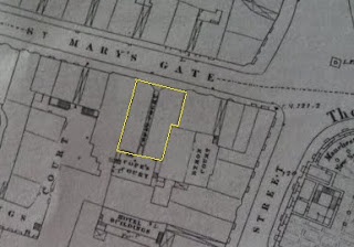
This pub isn't marked on the 1849 map but 'Ye Old Exchange Taverne' can be seen on the Goad's 1880 Fire Insurance map of Manchester, as shown here, courtesy of  Digital Archives [1]) and Andrew Simpson at the Chorlton History blog [2].  The pub was at 16-18 St Mary's Gate and was named after the nearby Royal Exchange, the upgraded version of which now houses the Royal Exchange Theatre.

Location of Exchange Tavern / Parker's Rest, St Mary's Gate. (c) Alan Godfrey Maps [3].

In 1839 the building was owned by Frederick Cope who was a wine and spirit merchant in partnership with his brother Richard.  They had various outlets, including the still surviving Sawyers Arms, and eventually they opened the Exchange Tavern, perhaps initially as a beerhouse.  When the Copes sold the pub to the Parker family in the 1890s, they renamed it Parker's Rest and it was then described it as a restaurant.  The 1849 map above shows Cope's Court to the rear of the pub, named after the family [3].


Exchange Tavern, St Mary's Gate. (c) Digital Archives (www.digitalarchives.co.uk) [1].

St Mary's Gate and Exchange Street were badly bomb-damaged in WWII, possibly in the Christmas blitz of 1940, but this illustration of St Mary's Gate shows the block that housed the Exchange Tavern - the pub was on the right, the Royal Exchange in the distance.  More recent bomb damage in the area, by the IRA in 1996, also saw the buildings on St Mary's Gate receive further face-lifts.  Thanks to Andrew Simpson for the history of this almost-forgotten pub [2].

1. Digital Archives - www.digitalarchives.co.uk.
2. Andrew Simpson - http://chorltonhistory.blogspot.com.
3. Manchester City Centre 1849, Alan Godfrey Maps (2008).

Cross Keys, Broad Street


Cross Keys, Broad Street, Pendleton, Salford, 1968. (c) Arthur Brougham with family's permission.

Two doors down from the Bay Horse was this little pub, the Cross Keys, on the corner of Cross Street and Broad Street.  Before the Allerton Building of the University of Salford was built, the Cross Keys faced the small Leaf Square.

Cross Keys, Broad Street, Salford. (c) Ur pictures of weaste by john quinn.

The Cross Keys opened in 1856 in Pendleton, Salford, and when Walker & Homfray took ownership in the early 20th century, they planned to rebuild the beerhouse.  


Cross Keys, Broad Street. (c) Salford Pubs of the 70s at flickr [2].

The rebuilding plans were withdrawn in 1905 so that the brewery rebuilt the Original on Lower Broughton Road instead.  Some minor improvements took place including a tiles on the small Broad Street frontage, and the Cross Keys passed to Wilsons brewery before it closed in 1971 [1].  


Cross Keys, Broad Street. (c) Neil Richardson [1].

1. Salford Pubs - Part Three: Including Cross Lane, Broad Street, Hanky Park, the Height, Brindleheath, Charlestown and Weaste, Neil Richardson (2003).

Stag Inn, Hodge Lane

Stag Inn, Hodge Lane. (c) Ur pictures of Weaste by john quinn.

The Stag Inn sat on Hodge Lane, roughly on the corner with where Athole Street is today, from the 1850s until 1968 [1].  Groves & Whitnall owned the pub and the house next door and they clearly rebuilt it at some point, complete with their distinctive white tiling.

Stag Inn, Hodge Lane. (c) Neil Richardson [1].

1. Salford Pubs - Part Three: Including Cross Lane, Broad Street, Hanky Park, the Height, Brindleheath, Charlestown and Weaste, Neil Richardson (2003).

Wednesday, 18 January 2012

Bay Horse, Broad Street

Bay Horse, Broad Street, Salford. (c) Ur pictures of weaste by john quinn's Photos.

The Bay Horse on Broad Street was first recorded in 1863 and a few years later in the Salford Reporter advertising "good ale and porter."  Next door to the Bay Horse in the 1880s was a fried fish shop  (a chippy?) which drew complaints to the authorities ("disagreeable to the neighbourhood") and in 1886 the problem was solved by incorporating the shop into the pub [1].  

Bay Horse, Broad Street, Salford, 1970. (c) Neil Richardson [1].

The frontage was extended into the front garden later, before Groves & Whitnall took ownership and they rebuilt it into the three-storey pub shown here.  The Bay Horse became known as 'The Monkey' as the landlord from the 1920s to 1940s, John McKinna, kept a pet monkey in the pub.  From the 1950s, Greenall Whitley assumed ownership before it closed in January 1971 [1].  The former location of the Bay Horse was roughly where Almond Close is today.

Bay Horse, Broad Street, Salford. (c) Salford Pubs of the 70s at flickr [2].

1. Salford Pubs - Part Three: Including Cross Lane, Broad Street, Hanky Park, the Height, Brindleheath, Charlestown and Weaste, Neil Richardson (2003).

Duke of Cumberland, Cumberland Street

At the end of Brazennose Street across Deansgate today sits the front of the Spinningfields development.  From the 1849 map shown below, it's clear that the name Spinningfields was taken from the old street that used to pass just north of here - Spinningfield.  The next street south was Cumberland Street which ran directly along the path of Brazennose Street, on to meet up with Dolefield (which itself ran all the way down to Hardman's Street).  One-third of the way along Cumberland Street on the left side was the Duke of Cumberland.  To its rear was the tiny St Mary's Chapel School R.C. (Day and Sunday) down Austin Street - the school was no bigger than the pub [1].  Also to the rear of the pub were nine court dwellings - nine tiny houses all facing inwards to Taylor's Court, each of which will have housed large families while the court will may have housed their animals and will have acted as dumping ground for rubbish and worse. 

Duke of Cumberland, Cumberland Street, 1849. (c) Alan Godfrey Maps [1].

The Duke of Cumberland was at No.9 Cumberland Street and in the 1821-1822 directory was listed as being run by Hector Tinling [2]. It hadn't always been a pub, and was in fact a Poor House originally. Number 9 Cumberland Street was advertised in The Mercury in May 1803 as "two extensive and commodious dwelling houses, with gardens, outbuildings and other conveniences thereto belonging... situated in Deansgate... in the present possession of Mr Barrow and Mrs C. Marriott."  The advert explained the property was to let "either with or without the warehouses and cottages adjoining", which was probably the old workhouse.  The property had been established in 1792 as the Manchester Poor House but by 1819 it had been converted into the Duke of Cumberland, and remained so for over 80 years, changing its name to the Cumberland Arms in 1876.  In 1901 it had ceased being a public house [3].

1. Manchester City Centre 1849, Alan Godfrey Maps (2008).
2. http://tinlingenealogy.org/trees/manchester.htm.
3. Provision for the relief of the poor in Manchester 1754-1826, Gordon Bradley Hindle (1975).

Sunday, 15 January 2012

Tanners Arms, Oxford Street

Tanners Arms, Oxford Street, Salford. (c) Salford Pubs of the 70s at flickr [1].

Oxford Street in Salford used to be a main thoroughfare that passed south from Regent Road, past the iconic Salford Lads Club on the corner of Coronation Street and what was Oxford Street (and previously Henrietta Street).  A few yards down the street and on the other side of the road was the Tanners Arms on the corner of Martha Street.  It was first owned by Broadbent's Steam Brewery of Chorlton-on-Medlock and in 1892 the landlord was advertising Broadbent's Bitter, Mild, 'C' ales and fine cigars.  The Manchester Brewery took over and refurbished it when Broadbent's closed, as they surrendered their license at the Staff of Life [2].  The Tanners Arms passed to Threlfalls, it lasted until 1971 and it was demolished later in the '70s [1].  

Tanners Arms, Oxford Street, Salford, 1920s. (c) Neil Richardson [2].

2. Salford Pubs - Part Two: Including Islington, Ordsall Lane and Ordsall, Oldfield Road, Regent Road and Broughton, Neil Richardson (2003).

Saturday, 14 January 2012

Paul Pry / I Hope I Don't Intrude Inn, Broughton Road

Paul Pry / I Hope I Don't Intrude Inn (1), Broughton Road. (c) Neil Richardson [1].

At the Greengate end of Broughton Road (now Blackfriars Road), the Paul Pry beerhouse was next door-but-one to the corner of Springfield Lane, opposite the Salford Union Workhouse.  It was first recorded in 1840, but by 1864 it had a new, more unusual name, the I Hope I Don't Intrude Inn, which was one of Paul Pry's lines in the John Poole play of the same name. The beerhouse was owned by the Adamthwaite family, whose firm Lupton & Adamthwaite part-owned the Cook Street Brewery before Threlfalls. Watson & Woodhead brewery leased the Paul Pry before Walker & Homfrays had it for the last two years until its closure in 1916 [1].

1. Salford Pubs - Part One: The Old Town, including Chapel Street, Greengate and the Adelphi, Neil Richardson (2003).

Lloyds Arms, Booth Street West

 
Lloyds Arms, Booth Street West. (c) Jonnyboy Smith at Facebook.

The Lloyds Arms was a "spit & sawdust" style boozer on Booth Street West off Oxford Road, shown as a plain-looking Bass house in this 1973 photo from the archives.  It was adjacent to the Royal Northern College of Music and today, the extension to the school covers the site of the pub.  Students and performers from the universities and music schools drunk in here and when much of the population of Chorlton-on-Medlock were moved out in the clearances of the 1960s and '70s, many ex-locals would return to their old pub.  So, especially at weekends, the Lloyds Arms was full of displaced families meeting up.  The last landlord, John and Vera Byre, firmly resisted demolition and the Lloyds Arms remained the only building on  the street for several years.


Former location of Lloyds Arms, Booth Street West. (c) Google 2011. View Larger Map.

169. Red Lion, Wilmslow Road

Red Lion, Wilmslow Road, Withington. (c) Gene Hunt at flickr under Creative Commons.

After the good (Friendship, VictoriaTurnpike), the bad (Sir Joseph WhitworthGreat Central) and the ugly (endearingly so - the Albert and the Orion), we finished our Fallowfield and Withington wander in the Red Lion.  This big old Marston's inn has always been popular with locals and students who mix well, and with its extensive outdoor seating and bowling green to the rear, is ideally situated, especially since it's the only remaining Lion around (the White Lion is now a Tesco and the Golden Lion's been demolished).  

Red Lion, Wilmslow Road, Withington. (c) Wikipedia under Wikipedia Commons.

However - and this is probably due its owners - it disappointed slightly due to the dull ale selection and the unappealing mish-mash of old fashioned and modern decor.  Give me the Victoria and Albert any day. Where the Red Lion does appeal is in its fantastic history.  The coaching inn can be traced back to the 17th century and is probably the oldest original building in Withington village, although many additions have been made over the years.  The Red Lion remains one of the most distinctive buildings in the area as you drive up Wilmslow Road into town and is nice slice of the countryside in the inner-city.

Huntsman, Wilmslow Road

Huntsman, Wilmslow Road, Rusholme. (c) Adam B. at flickr.

I would love this this theory about the Huntsman on Wilmslow Road to be true - that the pub is a front for an ancient Rusholme community of withered, malnourished, subterranean dwellers who are guarded by the smoking sentries that huddle around the front door [1].  Whilst the description of many of the Huntsman's old regulars may be unerringly accurate (here's one in 1959), I can confirm it was simply a very rough old Hardy's Crown boozer, situated in student central at the end of the curry mile.  

Huntsman, Wilmslow Road, Rusholme. (c) Gene Hunt at flickr under Creative Commons.

During our recent crawl around the old pubs of Maine Road, it was firmly shut as we passed between two great survivors, the Albert and Hardy's Well, and it appears to have "unexpectedly closed" in July 2011 [2].  I made the grand total of two visits to the Huntsman - the second of which was memorable for watching Ryan Giggs getting his chest rug out after his wonder goal against Arsenal in the Treble-winning season at Villa Park in front of just 30,000 (City had just defeated Luton 2-0 at Maine Road in the 3rd division).  Here's the Huntsman in 1971 and after a facelift in 1973.

1. http://drownedinsound.com/community/boards/social/4135614.
2. www.whatpub.org/guide/004000/Pub004274.htm.

Friday, 13 January 2012

Albert Park Inn, Great Clowes Street

Albert Park Inn, Great Clowes Street, Lower Broughton. (c) deltrems at flickr [1].

One of Salford's most recently built estate pubs, the Albert Park Inn only opened in 1983 under John Kain [2].  It was a pleasant and popular new pub at the time, offering a better place to drink for locals than the nearby House That Jack Built [1].  Even so, the pub was demolished in 2004, barely two decades after opening, after suffering from the all-too-familiar intimidation and occasional robberies that blighted Broughton's pubs at the time.  Sadly, a worker involved in the demolition of the Albert Park Inn was killed when he was hit by an excavation bucket on 22nd November 2004 [3,4].  The 2008 Google view of the area shows new flats being built on this corner of Great Clowes Street and Bandy Fields Place; the wall and gatepost of the pub can still be seen.

Albert Park Inn, Great Clowes Street, Broughton, 2004. (c) www.hse.gov.uk [4].

2. Salford Pubs - Part Two: Including Islington, Ordsall Lane and Ordsall, Oldfield Road, Regent Road and Broughton, Neil Richardson (2003).

Old Pack Horse, Oldham Road

Old Pack Horse, Oldham Road, Collyhurst. (c) Mick Burke & Frank Heaton [1].

This handsome little boozer was crammed in amongst the factories (and what looks like a church on the left) that once lined part of Oldham Road leading into town from Collyhurst through Miles Platting.  The Old Pack Horse was a Wilsons house and in the early 20th century was run by a Tim Carlisle.  He was a musical sort, and as well as running the pub, he sold sheet music in Blackpool, performed in plays and sung in pub concerts, while his sister Elsie was a locally famous singer in the 1920s and '30s [1].  By the 1970s, the factories around it were being pulled down and by the early 1980s, the Old Pack Horse was closed.

Remarkably, 1985 saw a restoration project on the Old Pack Horse, and this set of pictures show Wilsons  'restoring Manchester's oldest licensed premises'.  A year later and the Old Pack Horse is shown here in glorious colour, fully restored even if it is standing alone, with a car park to the right and flats visible to the rear.  Despite this noble restoration which must have cost a packet, it seems that the pub was demolished anyway as there is no trace of it on Oldham Road today in Miles Platting or Collyhurst.  Oddly, there is no mention of "Manchester's oldest licensed premises" on-line or in any more books.

1. Ancoats Lad, Mick Burke / Frank Heaton (1996).

Lowry, Langley Road South

Lowry, Langley Road South, Salford, 1990. (c) deltrems at flickr.

This wonderfully-grim '70s estate pub is still in use today as a church - apparently the Good News Assembly Pentecostal Church, although when the pub first closed, it became St George's Church [2].  The Lowry was built by Whitbread in 1977 as the estate pub for the new houses on Langley Road South when Whit Lane was replaced.  In 1986, Whitbread's Delamere Inns division kitted the Lowry out with prints of the aforementioned Salford artist, but by 1991 - a year after the above photo was taken - it had closed for good.


The former Lowry, Langley Road South, Salford. (c) Google 2011. View Larger Map.

1. www.flickr.com/photos/deltrems/2891977948.
2. Salford Pubs - Part Three: Including Cross Lane, Broad Street, Hanky Park, the Height, Brindleheath, Charlestown and Weaste, Neil Richardson (2003).

Thursday, 12 January 2012

Tamworth, Tamworth Street

Tamworth, Tamworth Street, Hulme. (c) Bob Potts [1].

The Tamworth was a Manchester Brewery then Wilsons house that stood on a lost street of the same name that ran off Stretford Road along what today is Nash Street [1].  The Tamworth Inn, to give it its full name and to differentiate it from the Tamworth House just up the street, was the penultimate Tamworth Street pub to close in 1965, in preparation for the disasterous Hulme regeneration of the late '60s and early '70s.

1. The Old Pubs of Hulme and Chorlton-on-Medlock, Bob Potts (1987).