Pubs of Manchester

All pubs within the city centre and beyond.
A history of Manchester's hundreds of lost pubs.

Friday, 30 November 2012

Greenwood Tree, Greenwood Road


Greenwood Tree, Greenwood Road, Benchill, 1994. (c) Alan Winfield with permission. 

The Greenwood Tree was a basic-looking, flat-roofed Tetley's estate pub in Benchill, on the corner of Gladeside Road, further down Greenwood Road from the Anvil.  Back in the 1970s, it looked like more of a family-oriented pub, but when it closed in the mid-2000s as a Burtonwood house, it had gone downhill and was forced to shut by the police due to guns and drugs being found on the premises following a gang-related murder.  The Greenwood Tree also suffered from the protection rackets of local gangsters like many pubs in the Wythenshawe area.

  
Former location of Greenwood Tree, Greenwood Road, Benchill. (c) Google 2012. View Larger Map.

Anvil, Greenwood Road


Anvil, Greenwood Road, Benchill, 1994. (c) Alan Winfield with permission.

The Anvil was another classic Wythenshawe estate pub on the corner of Haveley Road and Greenwood Road in Benchill.  This spot is just to the east of the M56 where it forks left and Princess Parkway starts.  


Former location of Anvil, Greenwood Road. (c) Google 2012. View Larger Map.

The Anvil was a Hydes pub, of course, named after the old Hydes Anvil brand.  It was your standard estate pub layout with a lounge and bar area and despite a rough reputation (like most Benchill pubs to be honest; like most Wythenshawe pubs, in fact), it lasted until 2004.

Hydes Anvil. (c) Barclay Perkins blogebay.

Sunday, 25 November 2012

Lantern, Hall Lane


Lantern, Hall Lane, Baguley. (c) With permission: Alan Winfield.

The Lantern was a classic Wythenshawe estate pub built by Greenall Whitley's in the 1960s on Hall Lane in Baguley.  

Lantern, Hall Lane, Baguley. (c) Sharstonbaths at YouTube.

The Lantern was probably demolished in the late '90s, but in the absence of much history, here are some great internal photos.


Lantern, Hall Lane, Baguley. (c) Sharstonbaths at YouTube.

 
Lantern, Hall Lane, Baguley. (c) Sharstonbaths at YouTube.

 
Lantern, Hall Lane, Baguley. (c) Sharstonbaths at YouTube.


Lantern, Hall Lane, Baguley. (c) Sharstonbaths at YouTube.

Lantern, Hall Lane, Baguley. (c) Sharstonbaths at YouTube.

On the site of the old Lantern is this block of grim new-builds called Lantern Court opposite Baguley Hall.

Former location of Lantern, Hall Lane. (c) Google 2012. View Larger Map.

Saturday, 24 November 2012

Royal Thorn, Altrincham Road

Royal Thorn, Altrincham Road. (c) With permission: Northenden Old & New [1].

One of the last of the original Wythenshawe inter-war estate pubs (only the Yew Tree building stands today), the Royal Thorn survived until 2001 before being demolished to make way for an ugly office block.  It stood on the south side of Altrincham Road opposite the bottom of Netherwood Road at the Princess Parkway roundabout at Sharston.

Royal Thorn, Altrincham Road, Sharston, 2001. (c) Trafford Lifetimes.

The Royal Thorn is pictured twice in 1959, close up in 1971 and in the distance with the Wythenshawe Adult Training Centre (now upgraded to an Open University site) in the foreground.  The pub was named after the Ryle Thorn inn which once stood here; itself named after the area which was known as Ruyul or Ryle Thorn in the 16th century.  In its final years, the Royal Thorn was renamed the Royals Hotel but is shown here being pulled apart in 2001.


Royal Thorn, Altrincham Road, Sharston, 2001. (c) Trafford Lifetimes.

Who says Manchester City Council don't respect the city's history? They at least paid lip service to the history of the old pub by naming the office block The Royals.  In the years I've been passing this building twice a day, it's never been fully occupied.  The same cannot be said of the Royal Thorn over the decades, once a busy boozer serving this corner of Manchester's "garden estate" of Wythenshawe.

Former Royal Thorn, Altrincham Road. (c) Google 2012. View Larger Map.

1. www.northendenpast.co.uk/new/?attachment_id=302.
2. www.trafford.gov.uk/content/tca.

Royal Oak, Altrincham Road

The Royal Oak was the first pub on the new Royal Oak estate in Bagluey, built by Wilsons in 1936.  Pictured in 1971 and shown here in the 1950s from the bowling green at the back, this huge boozer replaced an original 'Oke' seen in 1933.   It had stood here since the 16th century and became the Royal Oak after the restoration of Charles II.  The 1876-77 map below shows the original pub before the Wythenshawe estate encroached into Baguley.

Royal Oak, Altrincham Road, Baguley. (c) www.old-maps.co.uk/index.html.

The new Royal Oak was a classic inter-war estate pub with numerous rooms - saloon bar, refreshment room, ladies room, public bar and assembly room.  Healthier pursuits alongside drinking were encouraged with the bowling green and tennis courts to the rear, as seen on the 1938 map after the estate was built to the south of Altrincham Road.

Royal Oak, Altrincham Road, Baguley. (c) www.old-maps.co.uk/index.html.

There is a still a building offering refreshments of sorts to the Baguley community on the site of the Royal Oak, although sadly it's the cardboard, grease and fizzy pop of McDonald's.  It's debatable whether this ugly low rise building and its junk food fayre offers more to the locals than the lost Royal Oak.

Former location of Royal Oak, Altrincham Road. (c) Google 2012. View Larger Map.

Friday, 23 November 2012

Sharston, Altrincham Road

Sharston, Altrincham Road, Sharston. (c) With permission: Northenden Old & New [1].

The Sharston was another of the huge Wythenshawe inter-war estate pubs built for Manchester's new "garden estate" in the 1920s.  The above photo of the Wilsons house is by Mr B. G. Boyle, hosted at the excellent Northenden Old & New site with kind permission, and it's also seen here in 1955.  This substation on Altrincham Road at the Sharston roundabout is still labelled the Sharston Hotel, as seen on a close-up.  The Sharston has been swallowed up by the M56 Sharston bypass, which was built in 1970 and now scythes through what used to be Sharston's shopping precinct, in the distance in the below view, around the Altrincham Road-Mullacre Road junction.


Former location of Sharston, Altrincham Road. (c) Google 2012. View Larger Map.

Tuesday, 20 November 2012

Benchill, Hollyhedge Road

Although "Europe's largest council estate" (still a claim to fame?) is at least 8 miles south of the city centre, Wythenshawe's inhabitants are largely generations of inner-city families who were moved on during slum and inner city clearances.  Manchester's sprawling "garden city" started being built in the 1920s and soon there were pubs built to serve the incoming populations.  Some of the first boozers were grand public houses built at strategic locations around the nine districts of Wythenshawe - the Yew Tree (Northern Moor), the Royal Thorn, the Royal Oak (Baguley).  Sometimes they were sometimes simply named after their district - The Newall Green, The Sharston, The Benchill.

Benchill, Hollyhedge Road, Benchill. (c) Google 2012. View Larger Map.

The Benchill sat on the Hollyhedge roundabout in the centre of Benchill, and in its day was a heaving Threlfalls then Whitbread pub which developed a slightly unsavoury reputation over the years:
  • Was walking past it one summers day in the mid-eighties around 11.30 in the morning and decided to see what it was like.  As I walked in, the only people in the place were two guys in their fifties who were having a full-on fist fight.  The landlord was polishing glasses as if it was an everyday occurrence (which it probably was) [1].


Benchill, Hollyhedge Road, Benchill. (c) Google 2012. View Larger Map. 

When the Benchill closed - at some point in the last decade or two - it became a housing office, although it was finally demolished just a few months ago in Autumn 2012.  The Benchill Hotel opened in 1936, and a Manchester Evening News article of the day, transcribed at the Manchester Family History Research site, contains some evocative descriptions of the newly erected pub:
  • It seems only a very short time the site of the hotel was almost inaccessible, brooks and hollows separating the shopping area in Hollyhedge Road from the fields beyond.
  • Development is rapidly going ahead, housing schemes are being carried out at the front and rear of the new hotel, roads are pegged out, school buildings have been started, and in a comparatively short time what is now green pasture land will become one of the largest section of the Wythenshawe satellite town.
  • Messrs. Threlfall's of Salford, having regard to the importance of the site, have spared no efforts or expense in providing what they claim to be on of the finest modern hotels since the war in this part of the country. 
  • With broad draw-up and a large parking ground for over 100 cars the hotel stands well back from the main road, and the quiet dignity of the building can be more fully appreciated.
  • The Benchill Hotel has been planned to give facilities under good conditions to all classes of customers. The large Central Lounge is entered from the forecourt through glazed revolving doors. The lounge is lighted and ventilated by a large ceiling lantern, and one end is entirely glazed and has French windows opening out on to an arched loggia near to the flagged terraces which during the summer months will be provided with teak tables and chairs.
  • Externally the hotel is reminiscent of many of the larger country houses of England. The brickwork is of narrow gauge sand-faced bricks set in cream tinted cement. The façade is picked out in the centre upper portion with solid oak half-timbered and cement panels, and the principal entrances are emphasised with flat lead-covered hoods carried on oak brackets. 
  • Simplicity of design characterises the whole of the building, and a well designed and beautiful hand made tile roof with swept valleys and bonneted hips lends charm to the building.
  • Messrs. Gaskell & Chambers (Lancs) Ltd. Have supplied their patent hygienic “Dalex” beer engines and patent “Hygex-Sillerite” rigid piping and fittings through which beers will be drawn by the most direct route from the cask to the counter [1].

Monday, 19 November 2012

Wythenshawe


“How do you actually get to Wythenshawe?” was the question I asked myself when it was decided we’d be ticking the delights of Manchester Airport’s neighbouring town.  A friend had been to Wythenshawe a few weeks previous to us so we decided to follow his lead and train it over to Heald Green and walk from there.  We didn’t see any pubs in Heald Green that were worth bothering with, the only one near the station is a giant Beefeater monstrosity – the type that reminds me of modern identikit football grounds – utterly soulless and frequented by people I really don’t want to mix with.

After asking a couple of people for directions to the nearest pub, we walked for about 20 minutes and eventually found The Tudor.

Tudor, Peel Hall Road, Wythenshawe. (c) onedayinwatford.

It’s a good sized pub in the middle of an estate, reasonably priced and a warm welcome to be had from the landlady.  It had the selection of lagers, ciders and ales that you'd expect to find in your average estate pub.  As I was still suffering from the previous night’s shenanigans (Sinclairs, Football Museum and Knott Bar) I opted for a bottle of cider, poured over ice.  Try not to judge me.

The Silver Birch was next and about a 15 minute stroll into the town centre (of which there isn’t much of).

Silver Birch, Poundswick Lane, Wythenshawe. (c) onedayinwatford.

The first I heard about this pub was back in February when some nugget decided to fire a couple of shots at the windows, I think that was what planted the seed to see what these parts had to offer.  It’s a pretty big Holt's house that was built in the late 1940’s and was packed when we got in.  After a decent wait at the bar we were served and retreated to the only spare table available (we’d done a lot of walking, not a chance of me standing at the bar).

Happy Man, Portway, Wythenshawe. (c) onedayinwatford.

A short walk from the Silver Birch is the Happy Man, a fantastic looking pub and another that was nicely busy when we arrived, although on opening the first door we were met head on by a kids party that was in full swing.  Thankfully we were able to swerve that and went in the main bar area.  A sign above the bar told us that ‘POLICE SURVEILLANCE CAMERAS ARE OPERATING IN THIS PUB’.  Nice.

Mountain Ash,  Wythenshawe. (c) onedayinwatford.

Just up the road is the Mountain Ash, which was surprisingly quiet when we arrived.  It’s another big pub with the bar in the centre of the pub, plenty of nooks and crannies, and (again) CCTV in abundance. Part of the pub was in near darkness until the landlady turned the lights on for us.  I’ve read a few bad reviews of this place recently but I have to say that, even though it wasn’t busy, I thought it was a decent pub.

Portway, Portway, Wythenshawe. (c) onedayinwatford.

Another 15 minute walk takes us to The Portway, yet another huge pub that was fairly busy when we arrived.  We entered through the side door into a room with a small bar and pool table in but because of the clientele in there (lads sprawled out over the seats, dying) we went in the lounge next door.

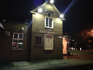
Cornishman, Cornishway, Wythenshawe. (c) onedayinwatford.

Next up, The Cornishman (after a standard circa 10 minute walk). They had the United game on so the place was packed.  My fellow pub ticker hit the jackpot in here when he ordered two beers and was told “that’s three pounds please”, “I asked for two pints” he replied, “that is for two pints love”.  They run a live football promotion where it’s £1.50 a pint until the first goal is scored, you can’t grumble at that.

Red Beret, Cornishway, Wythenshawe. (c) onedayinwatford.

Just down the road is the Red Beret (another big Wythenshawe pub, shock horror!).  I tried opening one door but it was locked, thankfully the lounge was open.  I ordered the beers and asked the landlady why the other room wasn’t open, she replied simply “MEETING”.  I didn’t pursue the conversation.  As darkness had long since fallen our thoughts had turned to getting back to Bury, we asked the landlady the distance to the nearest station and she told us Manchester Airport was easily walkable.  I double checked the route on the map on my phone and we eventually decided to get gone, in doing so we stumbled upon another boozer - The Woodpecker.

Woodpecker, Selstead Road, Wythenshawe. (c) onedayinwatford.

A smaller than your standard Wythenshawe pub, but still a fair size.  We had a quick one and then asked a local for a taxi number, only to be told that taxis no longer pick up from this pub.  PARDON?!  We’d already walked a good 5 miles so an extra mile wouldn’t kill us (and thankfully neither did the locals).

Wythenshawe is well worth an afternoon out, as you’ll have noticed you will walk miles but you’ll visit some of Manchester’s finest estate pubs [there are many more than the eight visited here].

As a side note, I reviewed the Spanking Roger for this fine blog earlier in the year.  It sadly burnt down a few weeks ago, thankfully no one was hurt.  That pub will forever be in my heart, RIP.

Spanking Roger, Sawley Street, Miles Platting, November 2012.

(c) Alan Horrocks, @onedayinwatford

Thursday, 15 November 2012

Summervilles, Bank Lane


Former Summervilles, Bank Lane, Irlam O'Th Height, Salford. (c) Google 2012. View Larger Map.

This building used to belong to Langworthy Rugby Club when it was based here, and in 1989 it became a short-lived private members' club operated by Bass called Summervilles [1].  Maybe it was the club house as No.2 Bank Lane looks very pub-shaped, and when Summervilles closed in 1993 it ended up as a tanning salon, Tropical Sun, also now closed.

Former Summervilles, Bank Lane, Irlam O'Th Height, Salford. (c) Google 2012. View Larger Map.

1. Salford Pubs Part Three: Including Cross Lane, Broad Street, Hanky Park, the Height, Brindleheath, Charlestown and Weaste, Neil Richardson (2003).

Britannia, Bank Lane


Britannia, Bank Lane, Irlam O'Th Height, Salford. (c) Salford Pubs of the 70s flickr [1].

The original Britannia stood at the junction of Manchester Road and Bolton Road beneath the modern-day Irlam O'Th Height roundabout.  It was pulled down in 1975 and a replacement Britannia was built by Wilsons Brewery round the corner on Bank Street.  It was a unique-looking, hexagonal-shaped estate pub with the lounge and games room on the upper floor and accomodation below, due to the dip in which the pub was built, and drinkers entered the pub by a short footbridge.  The Britannia opened in 1977 and closed just 17 years later in 1994 [2] and was pulled down sometime after 2001 as an Inntrapeneur Pub Company (Chef & Brewer) house, according to council records.  The postcode of the old boozer was M6 7LP which pulls up this location, so I suspect the pub was here where the new housing is.

Britannia, Bank Lane, Irlam O'Th Height, Salford. (c) Google 2012. View Larger Map.

1. www.flickr.com/photos/61756486@N05.
2. Salford Pubs Part Three: Including Cross Lane, Broad Street, Hanky Park, the Height, Brindleheath, Charlestown and Weaste, Neil Richardson (2003).

Wednesday, 14 November 2012

Billy Greens, Talgarth Road


Billy Greens, Talgarth Road, Collyhurst. (c) John Consterdine / @MCRTaxiTours.

This North Manchester estate boozer gained notoriety after it was featured on Sky's Britain's Roughest Pubs in 2004.  To be fair, Billy Greens - one of the last of the Collyhurst pubs - was then portrayed as a meeting place for local and exiled gangsters, and Man United top lads and grafters.


Billy Greens, Talgarth Road, Collyhurst. (c) 192.com / Local Data Company.

From memory, the programme also confirmed that the beer offering was limited to the standard estate pub keg and smoothflow offerings.  Billy Greens only closed in 2012 having been up for sale for a good few years, but it's already showing signs of terminal decay with its roof having been half-stripped of slate by local entrepreneurs.


Billy Greens, Talgarth Road, Collyhurst. (c) All rights reserved jhezza at flickr (downloadable here).

Billy Greens was named after the man who use to run the Vauxhall Inn on nearby Sophia Street.  Green moved from the Vauxhall Inn to the new estate pub, the Vauxhall Hotel, which was soon renamed after the landlord [1].

1. The Old Pubs of Rochdale Road and neighbourhood Manchester, Bob Potts (1985).

Friday, 9 November 2012

Prince of Wales, Moss Lane West

Former location of Prince of Wales, Moss Lane West, Moss Side. (c) Google 2012. View Larger Map.

The Prince of Wales was a huge Wilsons house on the corner of Upper Moss Lane and Moss Lane West, as shown here in 1970.  While Moss Lane West survived the Moss Side regeneration of the 1970s, Upper Moss Lane only has a short span remaining to the north in Hulme; the lower section seen here in 1972 is long-gone.  The Prince of Wales stood next to the Williams & Glyn's bank, as seen in 1972, and used to also mark the last stop on the Manchester Corporation Tram route from town, until the 1920s when they were carried on until Whalley Range.

Empress, Sloane Street

Sloane Street (Sedgeborough Road), Moss Side. (c) Mancky.

The Empress is shown at No.4 Sloane Street, Moss Side as a Wilsons house in 1971 and 1972.  In both these archive photographs, the building next door to the pub is sadly derelict, and it wasn't long after that the building and the Empress, along with the rest of Sloane Street, was pulled down.  The street was renamed Sedgeborough Road after redevelopments, as confirmed on the wonderful Mancky website, who discovered that Emmelline Pankhurst's was born here on Sloane Street.

Black Horse, Greek Street

Black Horse, Greek Street, Chorlton-on-Medlock, 1952. (c) Bob Potts (1997).

The Black Horse was one of the first alehouses in Chorlton-on-Medlock, opening in 1821 on Greek Street off Grosvenor Street.  It became a Walker & Homfray and then Wilsons three-storey house before it closed in 1964 [1].  Greek Street still exists today, a short dead-end, and the Black Horse stood a few doors down on the left, just where it ends.


Former location of Black Horse, Greek Street, Chorlton-on-Medlock. (c) Google 2012. View Larger Map.

1. The Old Pubs of Hulme and Chorlton-on-Medlock, Bob Potts (1997).

Town Hall, Broad Street


Town Hall, Broad Street, Salford. (c) Salford Pubs of the 70s at flickr [1].

Pendleton Town Hall used to stand on Broad Street before they moved to Broughton Road in the 1860s, so when the offices became vacant, the New Town Hall Hotel was established by James Higham in 1867. The beerhouse was shorted in name about five years later and by the end of the century the Town Hall had passed to Wilsons via Cardwell & Co of Hulme.  Wilsons rebuilt the old house into a three-storey boozer which lasted until January 1971 and it was pulled down shortly after [2].  The Town Hall stood roughly opposite Broughton Road where the roundabout is today.


Town Hall, Broad Street, Salford. (c) Neil Richardson [2].

1. www.flickr.com/photos/61756486@N05.
2. Salford Pubs Part Three: Including Cross Lane, Broad Street, Hanky Park, the Height, Brindleheath, Charlestown and Weaste, Neil Richardson (2003).

Greyhound, Broad Street


Greyhound, Broad Street, Salford, 1970. (c) Salford Pubs of the 70s at flickr [1].

This beerhouse was originally the Richmond Brewery Inn, named after this section of Broad Street which was known as New Richmond.  It opened in the 1830s on the corner of Pimlot Street and the brewery attached was capable of brewing fifty different sizes of beer barrels. Brewing probably stopped in the 1880s and the beerhouse as renamed the Greyhound.  By 1920 it had been taken by Hardy's Crown Brewery  who rebuilt it the following decade wide a wider, cream cladded front.  As pictured here, by 1970 the Greyhound had passed to Bass Charrington but by January 1971 it was closed and knocked down later that year [1], eventually replaced by a health centre opposite Frederick Road.

Greyhound, Broad Street, Salford, 1970. (c) Salford Pubs of the 70s at flickr [1].

1. www.flickr.com/photos/61756486@N05.
2. Salford Pubs Part Three: Including Cross Lane, Broad Street, Hanky Park, the Height, Brindleheath, Charlestown and Weaste, Neil Richardson (2003).