Thursday, 30 June 2011

Bull's Head, Greengate

Bull's Head, Greengate, Salford. (c) Sarah Welsh.

The Bull's Head on Greengate is one of Salford's better known old, lost pubs.  Situated on Greengate, a few doors down from the old original Three Legs of Man (see left of second photo at link) and next door to the Old Shears at Salford Cross, the Bull's Head was a timber and plaster pub with four gables to the street.  There's an 1887 photo of the Bull's Head and old Salford Cross at the Trafford council archives, and one here which claims to be from 1950 but clearly isn't.

Bull's Head, Greengate, Salford. (c) grabstarter at ebid.

"It has suffered a good deal from restoration and alterations, however, and the roofs are now covered with modern slates. The south gable is built on crucks, an interesting survival in a wilderness of brick and mortar. The house, once the abode of the Allens, has lost the projecting porch and gable, which formerly gave it an air of distinction, and has fallen on evil days [1]."  

Bull's Head, Greengate, Salford. (c) ernieatqrstuv at ebay.

The Bull's Head appears on the front cover of Neil Richardson's first book on Salford Pubs [2].  Here the pub is pictured in 1878 and the licensee's name, Henry Nelson ("licensed dealer of foreign and British wines, spirits, ales and porters"), appears larger than the Bull's Head one.  The building is thought to date from 1590 and lasted as a pub until 1930 as Groves & Whitnall house and was demolished in about 1938 [2].

Bull's Head, Greengate, Salford, 1878. (c) Neil Richardson [2].

Bull's Head, Greengate. (c) crown_collectables_uk at ebay.

2. Salford Pubs - Part One: the Old Town including Chapel Street, Greengate and the Adelphi, Neil Richardson (2003).

Monday, 27 June 2011

Old Trafford Inn, Stretford Road

Former location of Old Trafford Inn, Stretford Road. (c) googlemaps.

Despite the name this old Hardy's Brewery pub was in Hulme rather than Old Trafford.  It was on the corner of Stretford Road and Erskine Road and is shown at the Manchester Archive flickr site in 1962, with a rather addled looking bearded gent outside pointing.  He was probably pointing at a fellow drinker from the Platford, as this stood over Erskine Road from the Old Trafford Inn.  Indeed, the Talbot and still open Three Legs of Man are right nearby so this must have been a convenient little four-pub-hop when all were still trading.  The Old Trafford Arms was the first to close in 1968 [1] (suppose a betting shop and off licence is a reasonable replacement for a pub).


Three Legs of Man, former Old Trafford Inn, Platford, Talbot, Stretford Road. (c) googlemaps.

1. The Old Pubs of Hulme and Chorlton-on-Medlock, Bob Potts (1997).  

Sunday, 26 June 2011

Wigan Arms, Sidney Street


Queens Arms, Sidney Street, Salford, 1922.  13: Queens Arms, 14: Wigan Arms, 15: St Johns Tavern. (c) Neil Richardson [1].

The Wigan Arms stood next door to the Queens Arms on Sidney Street, near to Ye Old Nelson.  Although it opened in 1860 under John Halliwell, 20 years after its neighbour, its better trade (and the Scuttlers) eventually saw off the Queens Arms.  An 1878 licensee, Edward Read, had come to the Wigan Arms in Salford from a Hilton Street beerhouse, an area of Manchester notorious for its illegal betting shops.  The police soon caught him at it when his in-pub bookies was raided [1].  

Former location of Wigan Arms, Sidney Street, Salford. (c) googlemaps.

The Sun Brewery of Ford Lane, Salford was listed as the owners of the Wigan Arms in 1876 before Groves & Whitnall had the pub, 20 years later.  The Wigan Arms lasted until about 1960 when it was included in the compulsary purchase orders for the Islington area of Salford.  The last licensee was Betsy Lyons [1].  Now this area is nowt but a car park; the exact site of the Wigan Arms being two houses down from the car park entrance (formerly Mason Street) on the right down Sidney Street, where North Star Drive has chopped the street in half.

Queens Arms. Sidney Street, Salford. (c) googlemaps.

1. Salford Pubs - Part Two: Including Islington, Ordsall Lane and Ordsall, Oldfield Road, Regent Road and Broughton, Neil Richardson (2003).

Queens Arms, Sidney Street

Queens Arms, Sidney Street, Salford, 1922.  13: Queens Arms, 14: Wigan Arms, 15: St Johns Tavern. (c) Neil Richardson [1].

The pub shown on the corner of Chapel Street and Sidney Street on the above 1922 map extract is the still standing and recently closed Ye Olde Nelson.  On the other side of Sidney Street past the closed (spot the theme) solicitors is a car park and this used to be Mason Street. Just past Mason Street were two neighbouring pubs, the Queens Arms and Wigan Arms (there was another, unnamed beershop further down Sidney Street, past where the newer North Star Drive cuts across [1]).  The Queens Arms was run by Adam Scott from 1840 and by 1890 the beerhouse was owned by the Cardwell & Company brewers of Hulme.  Wilsons Brewery took over the Queens in 1899 but in 1906 the police reported that it was frequented by "youths of the Scuttler class" at the brewster sessions.  Next door was also doing better trade - down to a barrel and a half of beer a week - so the Queens closed and Wilsons were compensated £698 [1].


Queens Arms. Sidney Street, Salford. (c) googlemaps.

1. Salford Pubs - Part Two: Including Islington, Ordsall Lane and Ordsall, Oldfield Road, Regent Road and Broughton, Neil Richardson (2003).

Goodwill Tavern, Adelphi Street

Goodwill Tavern, Adelphi Street, Salford - 70: Dock & Pulpit / Borough, 71: Goodwill Tavern, 72: Brewery Tavern. (c) Neil Richardson [1].

Just up Adelphi Street past the still open Old Pint Pot (former Adelphi Riverside, and still to do) and lost Brewery Tavern, on the same side as the former, was the Goodwill Tavern.  In the 1830s a log wood mill stood here on the banks of the meandering River Irwell, being run by John Arrowsmith who is also recorded as beer seller at the tavern.  In 1875 the authorities tried to close the Goodwill Tavern, as the premises didn't have the required rateable value, but improvements were made and it lasted into the next century.  The last licensee was Norah Glennon in 1903, although soon after engineering works were built over the site, and these themselves have recently been knocked down:


Former location of Goodwill Tavern, Adelphi Street, Salford. (c) googlemaps.

1. Salford Pubs - Part One: The Old Town, including Chapel Street, Greengate and the Adelphi, Neil Richardson (2003).

Saturday, 25 June 2011

Royal Exchange, Exchange Street

The Exchange, Exchange Street, 1849. (c) Alan Godfrey Maps [1].

Manchester has had four Royal Exchanges and some of them contained pubs within.  The first Exchange was built in 1792 in Market Place, the other side of Market Street to where its larger replacement was built between 1806 and 1809.  In 1804 "the inhabitants of Manchester and Salford" had decided that:

"The erection of a handsome building in the Market Place for the general purposes of a commercial coffee room and tavern is highly desirable, and would afford great accommodation to the merchants and manufacturers in this town and neighbourhood [2]."

Royal Exchange, 1877. (c) Revealing Histories.

The new Royal Exchange on the south side of Market Street with its traders tavern was a huge success with 5,520 members by the 1860s.  These two images from the 1800s show the enlarged Exchange which presumably also had bars for thirsty traders to sup in after work.  Although this replacement was larger, it only lasted until 1914 when it was further extended to the Royal Exchange we know today and which was then the largest trading room in the country.  

Royal Exchange, Exchange Street, 1885. (c) Francis Firth.

The 1849 map above and today's, below, show that a couple of old streets - Ducie Place and Crow Street - and Newall's Buildings have been lost due to the Exchange's expansion [1].  The Grade II listed building is no longer used for trading - it ceased in 1968 - but houses the Royal Exchange Theatre within who've occupied it since the 1970s.  The 1996 IRA bomb did its worst, exploding 50 yards away, but the vast stone building was largely unharmed apart from its dome moving, and the Royal Exchange is even credited for protecting St Ann's Church from damage.

The Exchange, Exchange Street. (c) Alan Godfrey Maps [1].

1. Manchester City Centre 1849, Alan Godfrey Maps (2008).
2. A History of Manchester, Stuart Hylton (2003).

Wednesday, 22 June 2011

City Arms, Oldham Road

City Arms, Oldham Road, 1981. (c) Neil Richardson [1].

The City Arms is seen here in 1961 on Oldham Road, next door to Granelli's "Noted Ices".  In fact, the pub had ceased to exist since 1938 when it was taken over by Granelli's.  The shop is looking sorry in 1981, above, but the old pub continued to act as the ice cream parlour. The City Arms opened in a former pawnbroker's shop in 1864, and was one of three licensed houses in this row - the Spread Eagle was two doors down and the short-lived Friendship two doors up [1].


Former location of City Arms, Oldham Road. (c) googlemaps.

The Wheatsheaf further up the road  (white first floor building at the end of the block, above)  is still, somehow, the one survivor of the this stretch of Oldham Road.  Unfortunately, the ornate tiled City Arms / Granelli's wasn't enough to save it from demolition a couple of decades ago.  The exact spot of the City Arms is opposite the public entrance to the Post Office depot.

1. The Old Pubs of Ancoats, Neil Richardson (1987).

Tuesday, 21 June 2011

Lima Arms / Squealing Pig, Peru Street

Lima Arms, Peru Street, Salford. (c) rednumber9 at youtube.

The Lima Arms was a South American themed estate style pub built by Whitbread in 1970.  Presumably the rather odd theme was down to the Peru Street and Mayan Avenue nearby.  In 1975 it was described as a community centre with the "Inca Room" (lounge) including a mural of the Andes to go with the obligatory bright lights and plastic seating. The vault, or should I say "Andes Room", had colour TV, electric tennis, one-armed bandits and two dartboards - a Manchester dart board (smaller, with no trebles) and a Rest of the World standard one [1].


Possible former location of Lima Arms, Peru Street. (c) googlemaps.

Beer on offer was push button Trophy and Chesters mild, Stella Artois, Heineken, Guinness and Tankard.  Pub grub ranged from rump steak to hotdogs and fish and chips for the delectation of the Adelphi estate regulars [1].  One of the infamous regulars in here was "Vinegar Vera" (look it up yourself!).  In 1993 the Lima Arms was renamed the Squealing Pig and then back to the Lima Arms in 1997.  By 1999 it had closed down and was demolished a year later in the new century [2].  Not sure precisely whereabouts the Lima Arms was on Peru Street - could have been somewhere on the wasteland pictured...

Possible former location of Lima Arms, Peru Street. (c) googlemaps.

1. The Manchester Pub Guide, Manchester and Salford City Centres (1975).
2. http://services.salford.gov.uk/forum/forumposts.asp?forum=20&id=94889&p=2.

Druids' Home, Silk Street

Former Druids' Home, Silk Street, Salford. (c) Eddie_Manchester at flickr.

The Druids' Home was a popular late 1960s Salford estate pub, built by Wilsons Brewery to replace an original Druids Home, on Silk Street just off Blackfriars Road - at least it was in the mid '70s when the Manchester Pub Guide covered it [1].  Cabaret turns, loud music, a young clientele, garish wallpaper and plastic seating in the large front lounge bar complemented electric pumped Wilsons bitter and mild, Carlsberg, Watney Red and Guinness.  A haven to the rear was the vault with darts and dominos, the Druids Home was described as "the pinnacle of the modern housing development style" of pub [1].

In the early 1980s, the Druids' Home turned into a Samuel Webster house and a few years later Banks's Brewery owned it.  Closing in 1987, Banks's soon announced that they had given up the licence for the Stowell Spire on Howard Street / Eccles New Road.  Although no longer a pub, the Druids Home still lives on today as a youth centre.

Former Druids' Home, Silk Street. (c) Google 2011. View Larger Map.

1. The Manchester Pub Guide, Manchester and Salford City Centres (1975).

Monday, 20 June 2011

Tilted Falcon, Kincardine Road

Another of Manchester's inner city estate pubs that have been lost to the communities they once served with distinction.  Tilted Falcon was a two-roomed Banks's house that served Banks's Bitter and Mild.  The Tilted Falcon stood at the corner of Kincardine Road and Dryden Street, just off Upper Brook Street / Plymouth Grove, and was not far from the better known Plymouth Grove pub, which is somehow still standing just a hundred yards or so away.


Former location of Tilted Falcon, Kincardine Road, Ardwick. (c) Adam B. at flickr.

A few years ago, probably around 2008, the Tilted Falcon was demolished to make way for housing.  It's sad that as more housing is built, it seems that the more pubs close in inner city Manchester.  The aforementioned Plymouth Grove, and the likes of the Bowling Green, SherwoodKings Arms, and more, have all gone the some way as the Tilted Falcon in recent times.  It's pictured by Alan Winfield at Pubs Galore.

Sunday, 19 June 2011

Gamecock, Boundary Lane

Gamecock, Boundary Lane, Hulme. (c) Adam B. at flickr.

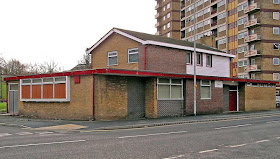
A distinctive and oddly-shaped 1970s estate pub that has been shut for a number of years now, the Gamecock stands in the shadow of some of Hulme's surviving flats on the corner of Boundary Lane and Booth Street West.

Gamecock, Boundary Lane, Hulme, 1975. (c) Neil Richardson [1].

There are rumours that yet more student accommodation will be built on the site of the Gamecock, a pub which has only stood here since 1974 when it opened as a Wilson's house, and seen in better nick in 1975 with its Watneys sign, above [1].


Gamecock, Boundary Lane, Hulme. (c) Gene Hunt at flickr.

1. The Old Pubs of Hulme and Chorlton-on-Medlock, Bob Potts (1997).

Bowling Green, Grafton Street

Bowling Green, Grafton Street. (c) Adam B. at flickr.

Never paid the Bowling Green a visit, but by all accounts it was a quiet and largely empty boozer in recent years which led to its closure in April this year.  Real ale was apparently on offer [1] and in this one-roomed boozer which had a beer garden out the back, presumably the old bowling green itself [2].  

Bowling Green, Grafton Street (c) Alan Perryman at flickr / East London Drinker.

Under competition from the nearby Grafton Arms, a Holt's house, and the various other cheap, student-friendly pubs along Oxford Road, it's no real surprise to see the likes of the Bowling Green struggle and eventually shut.  The East London Drinker blog about the Bowling Green is worth a read [1].

Bowling Green, Grafton Street. (c) ManchesterHistory.

Wednesday, 15 June 2011

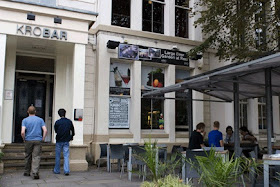
150. Kro Bar, Oxford Road

Kro Bar, Oxford Road. (c) frakture.

This is the original Kro Bar, part of the chain that boasts Kro2 further down Oxford Road towards the city centre, the popular Kro Piccadilly, the newer Kro Heaton Moor and Kro Trafford Centre, and the lesser known Kro Abbey Inn at the Science Park.  Housed in a Grade II listed row of old townhouses, there's large outdoor seating areas to the front and rear, and the bar offers a decent selection of beers and couple of real ales to the student and Academy gig-going crowds.

Kro Bar, Oxford Road. (c) wikipedia.

Website:  www.kro.co.uk.

Wallness Tavern, Wallness Lane

Wallness Tavern, Wallness Lane, Salford. (c) googlemaps.

The Wallness Tavern on the edge of Peel Park, Frederick Park and on the Salford University campus, has closed.  Although advertising itself as a student pub, it sounded like the classic off-the-beaten-track locals pub - erratic and short opening times, fierce locals and apparent hostility to outsiders.


Wallness Tavern, Wallness Street, Salford, 1989. (c) http://usir.salford.ac.uk/10482.

The Tetley house has undergone a few face lifts, with green, red and black signs over recent years, and the latest - a smokers tent - suggested a downwards spiral in recent years.  In the unlikely event that the Wallness Tavern reopens, we'll pay it a visit as the net spreads slowly outwards from the city centre...


Wallness Tavern, Wallness Lane, Salford. (c) googlemaps.

149. Jabez Clegg, Portsmouth Street

Jabez Clegg, Portsmouth Street. (c) ManchesterHistory.net.

A student haunt but handy for pre-Academy gig pints, this big boozer is tucked away down Portsmouth Street off Oxford Road.  It's named after the character from Mrs Linnaeus Banks' 'Manchester Man' and is contained within the old Holy Name Church Hall which was built in 1892 [1].  Inside it's an open hall-type space with pool and football tables.

Jabez Clegg, Portsmouth Street. (c) ManchesterHistory.net.

There's a good selection of real ale on offer and as you'd expect from a place that attracts those on a budget, beer is reasonably priced. Jabez Clegg's still turns into a student disco club night at the weekends which does attract a more mixed crowd as locals mix it with the student totty.


Jabez Clegg, Portsmouth Street. (c) ManchesterHistory.net.

Jabez has a couple of the better pub signs in town - 'Waiting Room' at the side entrance and the 'Beer Hall - Made Good in Manchester' sign out front.  The popularity of this place will never fade so long as Manchester remains the No.1 student destination.


Jabez Clegg, Portsmouth Street. (c) ManchesterHistory.net.

Website:  www.jabezclegg.co.uk.

1. http://manchesterhistory.net/manchester/tours/tour8/area8Bpage31.html.

Monday, 13 June 2011

Ace of Diamonds, Oldham Road

Ace of Diamonds, Oldham Road, Miles Platting. (c) google.com.

This pub was previously known as the Bird In Hand, but as the Ace of Diamonds it was brought to the national attention when it was heralded the Manchester HQ of the British National Party as the landlord ran for election for the BNP.  Subsequently, their odious leader, Nick Griffin, held press conferences here and the Ace of Diamonds, which was a well-used Miles Platting local, gained unwanted notoriety in the local and national press.  As a result of the BNP link, the pub was suddenly included in the Compulsory Purchase Orders in the area in 2009.  

Ace of Diamonds fire, Oldham Road, 2010. (c) IlluminatiManchester at youtube.

Even more mysteriously, on the 2nd April 2010 the Ace of Diamonds burnt down in what some claim was politically-motived arson.  A few yards up Oldham Road is the old Obsorne Theatre, also known as the New Osborne and Thunderdome, now sadly derelict but with a fine history of hosting Joy Division, New Order et al back in the day.

Nottingham Castle, Oldham Road

Former Notts Castle, Oldham Road, Miles Platting. (c) Google 2011. View Larger Map.

In the shadow of the Ancoats high-rises in Miles Platting, this furniture shop and 'Tropical Mini Market' is actually a big old estate pub, the Nottingham Castle.  As with many pubs around this part of inner city North Manchester, the Notts Castle - as it was known to locals - had a rough reputation.


Former Notts Castle, Oldham Road. (c) Google 2011. View Larger Map.

It's likely that an original Nottingham Castle pub was on this site and was replaced by the (then) modern and ugly estate pub that still stands today on this corner of Oldham Road and Naylor Street, unsurprisingly at number 342.  Here is a picture of the Nottingham Castle in its 1970s heyday.

Notts Castle, Oldham Road. (c) Miles Platting, Ancoats and Collyhurst Facebook [1].

1. www.facebook.com/groups/272836182813205/photos.

Talbot, Stretford Road

Talbot& Platford, Stretford Road, Hulme, 1965. (c) Bob Potts [1].

Adjacent to the recently closed Platford on the border of Hulme and Old Trafford, the old Wilsons house [1], the Talbot has been converted to a mini-mart and takeaway for some years, maybe over a decade.  


Former Talbot and Platford, Stretford Road, Hulme. (c) googlemaps.

1. The Old Pubs of Hulme and Chorlton-on-Medlock, Bob Potts (1997).

Platford, Stretford Road

Platford, Stretford Road, Hulme. (c) Adam B. at flickr.

This former Threllfalls and Whitbread house has closed only in the last year or so.  Formerly the White House, the Platford sits on the Hulme, Old Trafford border (see the sign on the far right, below).  The Platford is today adjacent to a building house a Afro-Caribbean mini-mart and takeaway, and this was formerly the Talbot [1].

Platford Hotel and former Talbot Inn, Stretford Road, Hulme. (c) googlemaps.

1. The Old Pubs of Hulme and Chorlton-on-Medlock, Bob Potts (1997).