Tuesday, 31 December 2013

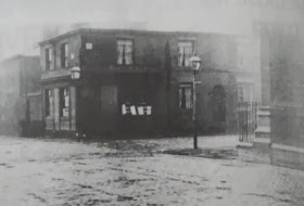
Bold Dragoon, Rochdale Road

Bold Dragoon, Rochdale Road, Collyhurst. (c) Manchester Local Image Collection. Click here to view full image [1].

A couple of doors up Rochdale Road from the Spread Eagle was the oddly named Bold Dragoon.  This beerhouse was licensed from 1847 to 1959, when the owners, Groves & Whitnall, surrendered its beer licence in exchange for a full one at the Great Western in Moss Side.  The name comes from a popular songs in Victorian times, The Bold Dragoon, although for a time in the nineteenth century the beerhouse was known as the Joiners Arms.

Bold Dragoon, Rochdale Road. (c) Bob Potts [1].

In the photo above, Livesey Street is out of shot to the left and the Bold Dragoon is the house in the centre that the lady crossing the road appears to be heading for.  Also partially shown are the Kings Arms (extreme right) and Spread Eagle (in the distance with the white side). There is little left along this stretch of Rochdale Road these days.

2. The Old Pubs of Rochdale Road and neighbourhood Manchester, Bob Potts (1985).

Three Pigeons, Bolton Road

Three Pigeons, Bolton Road, Irlams o'the'Height, Salford. (c) Neil Richardson [1].

The Three Pigeons was a beerhouse on the corner of Irlam Square, a few yards up Bolton Road from the still-serving Holt's house, the Red Lion, on the Height.  It can be traced back to the 1860s and by 1903 it had been taken over by Wilsons brewery.  This was an odd acquisition, especially as they then took out a new 10-year lease on the beerhouse despite it being on the closure list.  Licensee, James Greenwood, admitted he wasn't selling much beer and that the previous landlord had only pulled in the customers by pulling them free ale.  The Three Pigeons was duly closed in 1908 and Wilsons received £1,500 compensation, which wasn't bad when rent was only £65 a year [1].

1. Salford Pubs Part Three: Including Cross Lane, Broad Street, Hanky Park, the Height, Brindleheath, Charlestown and Weaste, Neil Richardson (2003).

Church Inn / St Georges Tavern, Rochdale Road

Former location of Church Inn, Rochdale Road, Collyhurst. (c) Google 2013. View Larger Map.

The Church was an impressive looking pub on the corner of Pilling Street and Rochdale Road, just north of the city centre in Collyhurst.  It was sadly closed in 1968 under a compulsory purchase order, having been fully licensed - latterly as as a Cornbrook Brewery house - since about 1808.  In the early days the pub was called the St Georges Tavern and it had a brewhouse attached.  The Church Inn was locally nicknamed the Clock Face or just the Clock due to the clock tower which faced onto Rochdale Road [1], as seen here in 1958.  Pilling Street has been renamed Pearing Street which still runs off Rochdale Street today near Collyhurst police station.

1. The Old Pubs of Rochdale Road and neighbourhood Manchester, Bob Potts (1985).

Brighton Inn, Charles Street

Brighton Inn, Charles Street. (c) Manchester Local Image Collection. Click here to view full image [1].

At No.17 Charles Street, the Brighton Inn was an imposing pub on the corner of Brook Street (now the end of Princess Street) and Charles Street.  It's pictured at the archives in 1907, and closed just 4 later in 1911 [2].  The Brighton Inn was on the north side of the River Medlock, which placed it just in historical Manchester rather than Chorlton-on-Medlock.  The site of the Brighton Inn is now taken by the Ibis Hotel which contains one of Manchester's best curry houses, East Z East, opposite the old Factory Records HQ (Paradise Factory) and diagonally across from Joshua Brooks and its neighbour, the Lass O'Gowrie.

2. The Old Pubs of Hulme and Chorlton-on-Medlock, Bob Potts (1997).

Brighton Hotel, Warde Street

Brighton Hotel, Warde Street, Hulme. (c) Hulme, C.on.M., All Saints, Ardwick at Facebook.

The Brighton Hotel stood on the south corner of Upper Duke Street and Warde Street, just south of Stretford Road in Hulme.  Shown here in 1963, the Brighton Hotel had a small Wilsons chequerboard sign on the door and it closed just a year later [2] - a victim of the Princess Road development.  The Brighton Hotel can be traced back to 1843 at No.49 Warde Street [3], a street which is long lost beneath the A5103, just north of the Hulme footbridge.

Former location of Brighton Hotel, Warde Street. (c) Google 2013. View Larger Map.

2. The Old Pubs of Hulme and Chorlton-on-Medlock, Bob Potts (1997).
3. The Old Pubs of Hulme Manchester (1) 1770-1930, Bob Potts (1983).

Tuesday, 24 December 2013

Angel Hotel, Chester Road


Angel Hotel, Chester Road, Stretford. (c) Trafford Council. Click here to view full image [1].

The landmark Stretford estate pub, the Drum, has recently closed and is sadly set for demolition.  Before the Bass Drum (to give it its original full name) and its sister pub, the lost Kettledrum over in Salford, were built, the Angel Hotel used to stand on this site.  Even before this, an original Angel pub stood here which can be traced back to 1780 - it was a whitewashed coaching inn with its own brewery [2].

Former location of Angel Hotel, Chester Road. (c) Google 2013. View Larger Map.

Linwood, Warwick Street

Linwood, Warwick Street, Hulme. (c) Hulme, C.on.M., All Saints, Ardwick Facebook.

Seen here in 1963 on the corner of Linwood Street and Warwick Street, the Linwood Hotel was a Tetley's house when it closed in 1967 [1] for the first redevelopment of Hulme. It had opened 95 years earlier in 1872 and was a Chesters boozer before it passed to the Leeds brewery [2].  The former location of the Linwood was roughly where Aquarius Street is in today's modern Hulme.

Linwood, Warwick Street. (c) Hulme, C.on.M., All Saints, Ardwick Facebook.

1. The Old Pubs of Hulme and Chorlton-on-Medlock, Bob Potts (1997).
2. The Old Pubs of Hulme Manchester (1) 1770-1930, Bob Potts (1983).

Sunday, 22 December 2013

Wellington Inn, Moston Lane

Wellington Inn, Moston Lane, Moston. (c) Manchester Local Image Collection. Click here to view full image.

On the corner of the wonderfully-named Capstan Street and Moston Lane, the Wellington Inn was a tiny but fully-licensed house, despite its beerhouse-size seen in 1959.  Capstan Street was formerly Charles Street, and I've no idea why it was renamed after a (i) famous cigarette brand or (ii) a nautical rotating machine.  

Former location of Wellington Inn, Moston Lane. (c) Google 2013. View Larger Map.

Talbot Hotel, Chester Road

Talbot Hotel, Chester Road, Stretford. (c) emartenet at ebay.

The Talbot Hotel was next to Stretford Town Hall at what is now the corner of Kingsway and Chester Road in Stretford.  It was built on the site of an old pub called the Bishop Blaize (which of course is now the name of the Wetherspoons further up Chester Road).  Pictured above in 1898, the Talbot Hotel is seen here in 1903, as an Openshaw's house here in 1951, and it was still standing by 1961 with a Wimpy next door.


Talbot, Chester Road. (c) Trafford Council. Click here to view full image [1].

Since the Talbot's demolition in the 1970s, this corner has not been replaced by anything.  The southern end of Stretford is slim-pickings these days, with only the Robin Hood and the O'Briens precinct pub since the Drum and Old Cock closed in recent years.  

Former location of Talbot Hotel, Chester Road. (c) Google 2013. View Larger Map.

Shrewsbury Hotel, Clifton Street

Shrewsbury Hotel, Clifton Street, Old Trafford. (c) Trafford Council [1].

The Shrewsbury Hotel was a Bass house on Clifton Street off Shrewbury Street in Old Trafford.  As seen above, it was still open in 2001 but by 2005 it was derelict.  Here it is in 1986.

Shrewbury Hotel, Clifton Street. (c) Friends Reunited.

The old Shrewsbury Hotel still stands behind Old Trafford Library at No.86, but it is now the Afifah High School for Girls.

Former Shrewsbury Hotel, Clifton Street. (c) Google 2013. View Larger Map.

Former Shrewsbury Hotel, Clifton Street. (c) Google 2013. View Larger Map.

Wednesday, 18 December 2013

Oaks Hotel, Barlow Moor Road

Oaks Hotel, Barlow Moor Road, Chorlton-cum-Hardy. (c) Manchester Local Image Collection. Click here to view full image [1].

Pictured in 1959, the Oaks Hotel on Barlow Moor Road, near to Princess Road, was built sometime after 1911.  Its heyday sounded like the 1950s, '60s and '70s when it was a popular drinking den and later disco venue with the likes of Peter Stringfellow DJing there.  The later '70s saw the pub used as post-punk venue with local bands like Slaughter & The Dogs and Ed Banger & the Nosebleeds (with the legendary Vini Reilly; The Durutti Column) playing there.  

Oaks, Barlow Moor Road. (c) Robin at Manchester District Music Archive [2].

Andrew Simpson at the Chorlton History site remembers the Oaks as a huge, rambling, multi-roomed building which sadly was usually empty apart from funeral parties from the nearby Southern Cemetery.  The Oaks closed in the early 1990s after a brief time as the Sports Bar and was demolished soon after [3].  These days a Premier Inn and its dull new-build pub, the Christie Fields, has replaced it.

Former location of Oaks Hotel, Barlow Moor Road. (c) Google 2013. View Larger Map.

Tuesday, 17 December 2013

Southern Hotel, Mauldeth Road West

Southern Hotel, Mauldeth Road West, Chorlton-cum-Hardy. (c) Phil Champion at Geograph under Creative Commons.

The Southern Hotel on Mauldeth Road West closed in 2011 after over 90 years of serving this corner of Chorlton-cum-Hardy.  Towards the end it was heavily Irish-themed with the Celtic Tiger nightclub and Mammy's Irish Kitchen part of this huge inter-war boozer.  This points towards the historically large Irish population of Chorlton, which is still apparent today in some of the trendy suburb's more traditional pubs.

Southern Hotel, Mauldeth Road West. (c) raver_mikey at flickr.

The Southern was built in the 1920s by Swales Brewery - rather unfortunately remembered around these parts for "Swales's Swill" - who ended up being taken over by Boddingtons in 1971 [1].  On my one visit to the Southern in the early 2000s it was Boddingtons Smoothflow that I had the misfortune to be served then.  It seemed to be struggling then and sporadic closures preceded the final one in April 2011.

Southern Hotel, Mauldeth Road West. (c) Jenics.

On a prominent junction on the corner of Nell Lane and Mauldeth Road West, the Southern had two large bars and seating area, plus a function room and two more bars on the first floor.  The old pub was recently for sale for £495,000, with its licence retained, although the estate agents were keen to stress the potential for alternative use [2].

Southern Hotel, Mauldeth Road West. (c) Phil Champion at Geograph under Creative Commons.

However, the news locally was that the Southern Hotel had been taken over this year by a curry house, and it's recently reopened as Sai Spice.  This end of Chorlton has sparse pickings pub-wise - just the cafe-bar place and the soulless new-build, Christie Fields (where the old Oaks Hotel used to be), on Barlow Moor Road.

Wednesday, 11 December 2013

Grove, Church Street

Grove, Church Street, Hanky Park, Salford. (c) Neil Richardson [1].

The Grove can be traced back to 1871 as the Grove Inn, and a few years later it was under the ownership of the Britannia Brewery, which later became the Manchester Brewery Company.  It once advertised 'Celebrated Ardwick Ales' on the corner of Ellor Street and Church Street, but by 1912 the Church had passed to Walker & Homfray.  The Grove closed in 1966 as a Wilsons house (as above in 1961 [1]) and its licence (plus a few others: the Grapes on Cross Lane and the Prince of Wales Feathers) passed to the Woodman, a new estate pub on Belvedere Road [1].  The old location of the Grove was roughly half way along Pendleton Way.

Woodman, Belvedere Road. (c) James Herring at Facebook.

1. Salford Pubs Part Three: Including Cross Lane, Broad Street, Hanky Park, the Height, Brindleheath, Charlestown and Weaste, Neil Richardson (2003).

Warwick Hotel, Warwick Street

Warwick Hotel, Warwick Street, Hulme. From Hulme, All Saints, Chorlton-on-Medlock, Ardwick Facebook.

The Warwick Hotel was a Groves & Whitnall house on the corner Halston Street and Warwick Street. It's seen here at the archives in 1963 on the corner of Halston Street looking towards Chapman Street (formerly Cossack Street), and above it is shown looking down Warwick Street towards Emben Street. The Warwick Hotel opened in 1855 at No.61 Warwick Street [1], and it closed 100 years later in 1965 [2] for the first re-development of Hulme. The old location of the Warwick Hotel is roughly where marked on the modern day map, along Arnott Crescent.

1. The Old Pubs of Hulme Manchester (1) 1770-1930, Bob Potts (1983).
2. The Old Pubs of Hulme and Chorlton-on-Medlock, Bob Potts (1997).

Thursday, 5 December 2013

Star Inn, Lissadel Street

Star, Lissadel Street, Charlestown, Salford. (c) Neil Richardson [1].

Pictured above in the 1960s, the Star Inn was on the corner of Rockley Street and Lissadel Street in Charlestown.  It opened at some point before 1855 and by 1903 it was owned by Chesters Brewery.  The Star was a fully-licensed public house and lasted well over a century until 1965 [1].  Lissadel Street still runs through this corner of Salford today; the spot where the Star Inn once stood is now a council house.

Former location of Star Inn, Lissadel Street. (c) Google 2013. View Larger Map.

1. Salford Pubs Part Three: Including Cross Lane, Broad Street, Hanky Park, the Height, Brindleheath, Charlestown and Weaste, Neil Richardson (2003).

Forresters Arms, Booth Street

Forresters Arms, Booth Street, Hanky Park, Salford. (c) Neil Richardson [1].

In what used to be a row of houses known as Richmond Place, on the corner of Richmond Street and Booth Street, the Forresters Arms opened in the 1860s.  Boddingtons Brewery had the Forresters by the start of the twentieth century and among the landlords over the years were William Connell, John Bond and Hilda Salt.  The latter was still pulling pints in here when it was forced to close on the afternoon of Black Sunday, 28th April 1963, for redevelopment of Hanky Park [1].  The above-mentioned Richmond Street later became Peel Street, so the site of the former Forresters is roughly where Spurce Court tower block stands on Broadwalk.

Former location of Forresters Arms, Spruce Court, Broadwalk. (c) Google 2013. View Larger Map.

1. Salford Pubs Part Three: Including Cross Lane, Broad Street, Hanky Park, the Height, Brindleheath, Charlestown and Weaste, Neil Richardson (2003).

Monday, 2 December 2013

York Hotel, Renshaw Street

York Hotel, Renshaw Street, Hulme. (c) Bob Potts [1].

The York Hotel stood on the corner of Booth Street and Renshaw Street and is pictured above in 1961 in Bob Potts' highly-recommended book [1].  This spot is now the corner of Freeman Square and Epping Street (as Renshaw Street was renamed in the 1960s Hulme redevelopments), as Booth Street (West) doesn't quite reach this far west any more.  The York Hotel opened in 1849 as a Watson, Woodhead & Wagstaffe brewery house [2], passing to Walker & Homfray [1].  The photo suggests it was rebuilt in 1909 and it passed to Wilsons before closing in 1963 [1] for the aforementioned redevelopments.  

Former location of York Hotel, Epping (Renshaw) Street. (c) Google 2013. View Larger Map.

1. The Old Pubs of Hulme and Chorlton-on-Medlock, Bob Potts (1997).
2. The Old Pubs of Hulme Manchester (1) 1770-1930, Bob Potts (1983).

Star Inn, Duke Street

Star Inn, Duke Street, Hulme, 1912. (c) Bob Potts [1].

On the corner of Devonshire Street and Duke Street, the Star Inn opened in 1841 and passed to Cronshaws and the Peter Walker & Son brewery of Warrington before closure in 1914 [1,2].  The Star was at No.101 Duke Street, which was off Stretford Road and later renamed Downside Street.  Princess Road has since replaced this street with the Hulme Arch marking the spot where it once ran north of Stretford Road.

Former location of Duke Street (Downside Street), Hulme. (c) Google 2013. View Larger Map.

1. The Old Pubs of Hulme and Chorlton-on-Medlock, Bob Potts (1997).
2. The Old Pubs of Hulme Manchester (1) 1770-1930, Bob Potts (1983).

Thursday, 28 November 2013

Priory Hotel, High Street

Priory, High Street, Hanky Park, Salford. (c) Neil Richardson [1].

Most of Hanky Park was wiped off the map in the mid-1960s, but there are some remnants, such as West Hight Street, which used to be simple the High Street, where the Priory Hotel once stood.  It was named after an old beerhouse that was lost when Pendleton New Station was built.  

The Priory Hotel was built on the corner of Ruthin Street and High Street in 1886 by Threlfalls, and for decades fought to get a full licence, a request which was repeatedly rejected until it was finally granted in 1937.  This only occurred when the Raven Hotel's licence on Chapel Street was transferred, as it was getting pulled for Victoria Bus Station.

In 1915, the Priory had its windows smashed during the Lusitania Riots as the landlord had a German-sounding name - he went to the trouble of putting up posters offering a tenner to anyone who could prove he wasn't English!  The Priory came to a familiar end - it was closed and demolished in 1965 under a compulsory purchase order [1].

1. Salford Pubs Part Three: Including Cross Lane, Broad Street, Hanky Park, the Height, Brindleheath, Charlestown and Weaste, Neil Richardson (2003).

Druids Rest, Pimlot Street

Druids Rest, Pimlot Street, Hanky Park, Salford. (c) Neil Richardson [1].

The Druids Rest stood on the corner of Peel Street and Pimlot Street in Hanky Park, and can be traced back to 1858.  When the landlord was fined for selling the "long pull" in 1907, the Druids Rest was a Threlfalls house, and Alfred Rimmer told magistrates that neighbouring boozers were doing it, so what could he do?  In 1913 Threlfalls rebuilt the frontage of the beerhouse and the Druids Rest lasted until 'Black Sunday', that fateful day, 28th April 1963, when most of Hanky Park's pubs and beerhouses were killed off [1].  Pimlot Street used to run from Broad Street (opposite Frederick Street) to Ellor Street, so the Druids Rest was just south of where Belvedere Road is marked.

1. Salford Pubs Part Three: Including Cross Lane, Broad Street, Hanky Park, the Height, Brindleheath, Charlestown and Weaste, Neil Richardson (2003).

Saturday, 23 November 2013

Welcome Inn, Lloyd Street

Welcome Inn, Lloyd Street, Hulme. (c) Bob Potts [1].

The Welcome Inn was originally known as the Flintshire House, as reported in the 1861 census.  Then-landlady, Elizabeth Williams and her husband were from Wales which explains the the Flintshire connection.  The Welcome Inn stood at No.20 Lloyd Street on the corner with Queen Street (now Quenby Street), and was a Hardy's then Peter Walker & Son house, closing in 1935 [1,2].  Lloyd Street was renamed Linby Street and still runs through Hulme, though no longer meets up with Chester Road.  One of the refurbished blocks of flats marks the spot where the Welcome once stood.

Former location of Welcome Inn, Linby Street (formerly Lloyd Street). (c) Google 2013. View Larger Map.

1. The Old Pubs of Hulme Manchester (1) 1770-1930, Bob Potts (1983).
2. The Old Pubs of Hulme and Chorlton-on-Medlock, Bob Potts (1997).

Church Inn, Chester Street

Church Inn, Chester Street, Hulme. (c) Bob Potts [1].

The Church Inn was at No.24 Chester Street and is pictured above in an old 1907 photo [1].  It opened in 1840 and lasted until 1923 as a Groves & Whitnall house [1,2].  The Church was towards the Great Jackson Street end of Chester Street; this part of the street was lost when the lovely Hulme 'redbricks' (Bentley House) estate was built.

Former location of Church Inn, Chester Street. (c) Google 2013. View Larger Map.

1. The Old Pubs of Hulme Manchester (1) 1770-1930, Bob Potts (1983).
2. The Old Pubs of Hulme and Chorlton-on-Medlock, Bob Potts (1997).

Dog & Partidge, Owen Street

Dog & Partridge, Owen Street, Hulme. (c) Bob Potts [1].

The Dog & Partridge is pictured in Bob Potts' book a century ago in the year it closed, on the corner of Ferneley Street and Own Street.  This location was just off Great Jackson Street at Knott Mill, Hulme.  The Dog & Partridge opened in 1851 and was a Groves & Whitnall house before passing to Walkers of Warrington until its closure [1,2].

1. The Old Pubs of Hulme Manchester (1) 1770-1930, Bob Potts (1983).
2. The Old Pubs of Hulme and Chorlton-on-Medlock, Bob Potts (1997).

Wednesday, 20 November 2013

Grove Inn, Grove Place

Grove Inn, Grove Place, Islington, Salford. (c) Neil Richardson [1].

The Grove Inn was on the corner of Islington Grove and George Street on the end of a row of houses known as Grove Place.  The beerhouse opened in 1860 and by the 1880s it was owned by Taylor & Horrobin, a brewery of which there appears to be no record.  The lease of the Grove passed to the Salford Brewery Company and then Chesters Brewery by 1892.  Chesters had plans to expand the Grove - see above - and in 1908 the beerhouse was allowed to be rebuilt.  It lasted until 1957 when it was lost to an Islington redevelopment compulsory purchase order [1].  The old location of the Grove is a little south of the wonderfully-named Firefly Close off Chapel Street.

1. Salford Pubs Part Two: Including Islington, Ordsall and Ordsall Lane, Oldfield Road, Regent Road and Broughton, Neil Richardson (2003).

Star Hotel, Regent Road

Star Hotel, Regent Road, Salford. (c) Neil Richardson [1].

The Star Hotel stood on the corner of West Brownbill Street and Regent Road and was first known as the Druids Call.  Dating back to the late 1860s, it was a Groves and Whitnall house by the 1920s and the brewery gave it a new brick and tile frontage.  The Star lasted until 1978 when it was adjudged to be unsafe after its neighbouring shops had been pulled down.  The fate of the Greenall Whitley house was the same and the site of the old Star is today under the Regent Road-Albion Way roundabout [1].

1. Salford Pubs Part Two: Including Islington, Ordsall and Ordsall Lane, Oldfield Road, Regent Road and Broughton, Neil Richardson (2003).

Sunday, 17 November 2013

Lord Roberts, Queens Road

Lord Roberts, Queens Road, Collyhurst. (c) Bob Potts [1].

The Lord Roberts closed in 1964, like much of Collyhurst, under a compulsory purchase order for redevelopments.  Originally the Waggon Makers Arms, the Wilsons house was renamed Lord Roberts and was known as 'Lord Bobs' by locals.  The Lord Roberts was at No.237 Queens Road and opened in 1836 as a beerhouse [1].

1. The Old Pubs of Rochdale Road and neighbourhood Manchester, Bob Potts (1985).

Prince of Wales, Collyhurst Street

Prince of Wales, Collyhurst Street, Collyhurst. (c) Bob Potts [1].

The Prince of Wales, a Threlfalls house, is shown above in the 1950s before a pub outing for the regulars.  At No.2 Collyhurst Street just off Rochdale Road, the Prince of Wales opened in 1852 and had over a century of serving before being closed and demolished in 1961 under a compulsory purchase order [1].

Former location of Prince of Wales, Collyhurst Street. (c) Google 2013. View Larger Map.

1. The Old Pubs of Rochdale Road and neighbourhood Manchester, Bob Potts (1985).